×

|
Rate it:
Tags:
Level: Intermediate
Length: 10 mi (16.1 km)
Surface: Singletrack
Configuration: Network
Elevation: +1,627/ -1,563 ft
Total: 71 riders
Mountain Biking Big South Fork
#24 of 205 mountain bike trails in Tennessee
In Big South Fork National Recreation Area, some steep deep woods trails, some moderate, lots of woods, creeks, logs, rocks, mud. Some technical, some not. Single track to dirt/gravel roads to short paved stretches. Great scenery.
First added by WBrown729 on Mar 27, 2005. Last updated May 2, 2020. → add an update
Before you go
- Drinking water: unknown
- Lift service: unknown
- Night riding: unknown
- Pump track: unknown
- Restrooms: unknown
- Fat bike grooming: unknown
- E-bikes allowed: unknown
- Fee required: unknown
This trail information is user-generated. Help improve this information by suggesting a correction.
From I-75 near Tn/Ky line take exit 141 to Tn Hwy 63 West, US 27 north to Oneida, 297 west to Big South Fork park, follow signs to Bandy Creek visitors center for instructions/maps.
System trails (4)


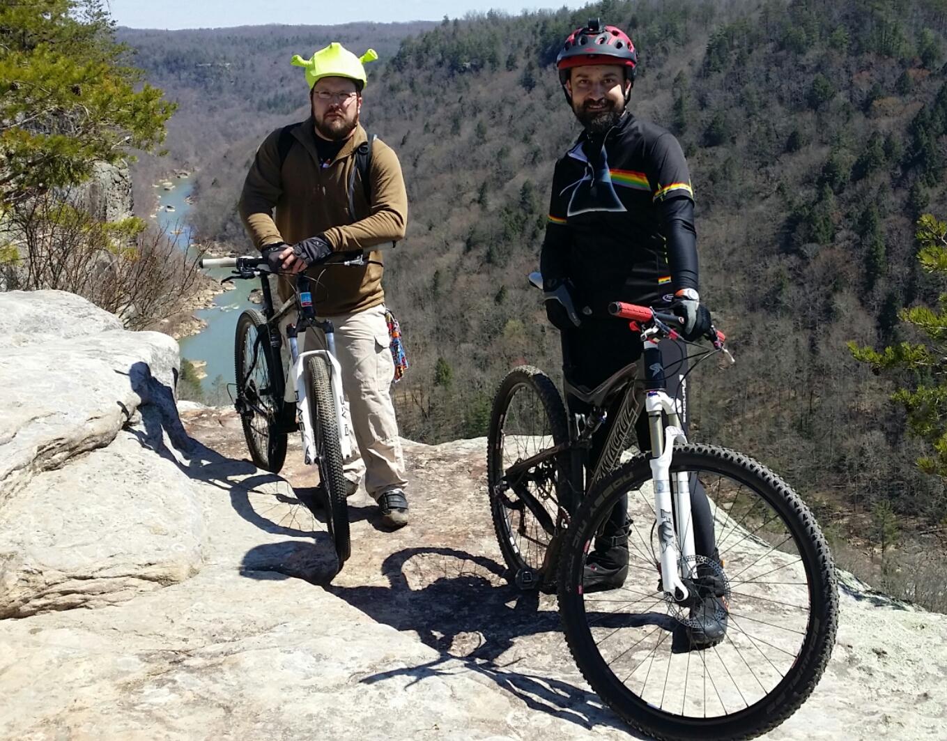

| ThankThis is a must ride. Excellent views and very well maintained. It is worth the 50 mile detour off of I-75
| ThankBest scenery I have seen in the south. Nice trail. Well maintained. The trail is well marked. Please adhere to the signs, when they say walk your bike. If you try to ride and fall it will be a while before you hit the ground. If you want to ride this trail by itself you will have to drive/ride on a dirt road for 4.2 miles to get to the trail head.
| ThankBest scenery I have seen in the south. Nice trail. Well maintained. Got tired of the spider webs though. I will try to return before the riding season is over.
| ThankI rode the Imba Epic 34 mile course that covers these trails and much more. Great trail! Nothing overly difficult other than the miles. The trail is very well marked and well maintained. The overlooks on grand Gap and John Muir are great places to take a breather and enjoy the scenery. Well worth the 1hr detour off of I-75
| ThankA fun trail that was well maintained. There were enough hills on it to have a good workout, but nothing too strenuous. There were a few rocky sections but not very technical. Next time I'm going to ride the gravel road to the TH.
| ThankFun little loop, part of the Big 5 IMBA Trails in the Big South Fork. Nothing too technical, but the elevation changes will keep you breathing.
| ThankThe Grand Gap is open to mtn biking 7 days a week now. The sand stone soaks up any moisture from rain, so trail conditions are always good. Three good overlooks along the gorge for photos. A couple of sections are marked with signs asking you to walk your bike.
| ThankThere is a reason BSFNRA obtained epic status. Trails include awesome overlooks, rock houses, old homesteads, fast flowing single track above and below bluffs. There are a couple of beginner friendly trails for the lesser experienced riders.
| ThankI have ridden all over the southeast and this is the most beautiful and fun trail there is. Better yet there are a lot of ways to ride it. For a longer ride go from Bandy Creek (this involves a lot of gravel roads). You can park at the parking area off Duncan Hollow Road (better but a big climb out). Or park right at the trail head for a pretty easy, scenic 6 mile loop.
The John Muir trailhead is right here as well and it's a great out and back or loop trail to complete a fantastic day.
| ThankBe sure to thank the rangers for giving us access to this awesome terrain.
Check out the Big South Fork Bike Club as well as they have been instrumental in opening up these trails for us.
One of the most beautiful trails I have ridden in the Southeast. Not only is the trail fun to ride, the overlooks are fantastic. You can ride from Bandy Creek or drive down and park at the trail head for a much easier ride. I like to add the John Muir trail as well as an out and back to make a 20 mile ride.
Be sure to stop in at the ranger station to thank them for the access.
| ThankWe rode this section after riding the john muir overlook trail. The trailhead is directly across the gravel road (Divide Rd) from the John Muir Overlook trail. It is fast and flowy at first then quickly decends down roughly 1500ft to the river. We like to call this area Middle Earth. The decent follows an old rail line and you can feel the cross ties under your tires as you bump your way down. This area is very technical and presents many difficult sections....FUN FUN FUN!. Once you get to the river bed there are many options to jump in the creek. There are numerous other trails that can be found down there where one can explore all day. We followed the John Muir then climbed back up to the Rock Creek trailhead then back to the gravel road. It was a tough climb out, lots of hike/bike sections but overall rideable.
| ThankRode Grand Gap with some new friends. This trail has a lot to offer, fast flowy, tech, rocky/rooty and some sweet lookouts. We saw several snakes along the way...a rattlesnake, a copperhead, a corn snake and a garder snake. The trail tread is very similar to other parts of the Sheltowee...sandy/rocky stuff that is uneffected by rain. Lots of trail here, plan to spend the night because there is just way too much cool trail to see in one day.
| ThankThis trail is a must if your in the area, it's fast, flowy and has some killer views of the Big South Fork. The trail rides right past some 250 ft overlooks...so please be careful. All easy to moderate difficulty with a few walk-a-bike sections and a few rooty/rocky spots. You can really get some speed on the fast flowing downhill parts. I rode it counter-clockwise but it can be ridden both. The trail is now open all the time for bikers and not just on the weekdays. Enjoy!
| ThankAwesome views with great trails. I rode Grand Gap counter clockwise and then rode John Muir north. This is what I would consider a destination trial. One of the best. Go ride it!!
| ThankGood well marked trail. You can park near the Bandy Creek Visitor Center for an easy ride out to the Duncan Hollow Bike Loop trailhead. The loop is short but has some serious climbs. If you were unable to make the climbs, it maintained enough that is is easy to push your bike up the trail.
| ThankGreat out and back trail that can be combined with other trails and roads to be a loop or figure 8. Open sunny at parts but then damp in low creek areas. Trail is well maintained and well marked. Leads out to the John Muir Overlook along Chestnut Ridge but my boys did not make it that far out. There are other sections of the John Muir that you can mountain bike in the BSF.
| ThankNice open trail at the beginning then descends into a creek valley and joins up with the John Muir Trail. We combined the two and utilized Divide Road for a 9 mile route.
| ThankGreat place to ride!!! 5 of the big south fork mountain bike trails just received "epic"status by imba fall of 2012. Great trails for all skills levels. West bandy loop, collier ridge trail, Duncan hollow loop, grand gap, and John muir. Just this month @ least 16 more miles of trail opened on the foe tress county side of the park. I believe it's called chestnut ridge. Trail description can be found on the Bigsouthfork mountain bike cubs website.
| ThankThe Grand Gap was an easy trail with spectacular views. It generally follows a ridgeline dodging into the forest then out along the ridges. Some sand along the trail as well as some wet spots. I took my two kids (8 and 11 years old) and they loved it. We were the only bikers or hikers on the entire trail. An outstanding way to enjoy the BSF on an afternoon. Well marked and well maintained. Provides some of the classic vistas of the Big South Fork.
| Thank