A: The part generally as far East as it goes, out by Christa Mcauliffe Park does seem to have biggest hills. If you go S just east of 43 on Moon Vly and cross the bridge, there're a trail on R. Follow that and cross RR and you can ride for a few miles, with some nice size hills and features, but its not reel down hill. Also to E, N of tracks should be some jumps and drops and stuff.


I suppose it has potential if ever properly marked and maintained. But as is no flow to it, washed away in parts, multiple branch offs so as first timer no clue. Also parts near creek are likely always muddy.
| ThankBest trail within an hour of the valley.
| ThankA lot of options for what kind of ride you want. West side starts easy, but ends with some great climbs and descents. East side is a lot of punchy climbs and fast descents. A few options for exciting descents, and there is a little jump area. Takes a few times to find your way around everywhere.
Nice trails. Very narrow in spots. Very poorly marked!
| ThankThis turned out to be a fun find. I parked off the parkway and headed west. It was very beginner friendly and I was beginning to think I made a mistake in coming here because I was hoping for more advanced trails. I also found it fairly easy to navigate. I had originally forgone riding here several times because I find it very frustrating to ride unmarked trails that have many spurs and that seemed to be the case in the comments. However, there are little orange squares on the trees and as long as you keep seeing those, you're on the trail that will eventually make a full loop. Once I got east of I-43, the fun began. The landscape was immediately changed and there were punchy climbs and sweeping turns. I then found myself in a field with several BMX style jumps and features. Once I had ridden through there, it was onward with my loop. I thought this section of the trail was great! It was easy enough for someone not familiar (with intermediate to advanced skills) to ride through at a decent clip. So fun navigating all the ups and downs! Once I crossed I-43 again, I was able to locate the trail north of the parkway and there was a similarly fun loop to ride in there as well. Switchbacks with a steeper climb and descent made this fun. The next time I stop here I will likely just do the east end twice and skip the beginner side. It was about 8 miles in total which is long enough to avoid boredom in short laps.
| ThankReally fun trail and getting better all the time. West end is the easiest. East of I-43 more fun and flowy. N of Baird Crk Rd has very steep climbs.
| ThankIf you go here without someone who knows the trail system like I did I guarantee you will get lost, but there is some amazing stuff here. There is a lot of verticality in a valley by the stream on the east side of the underpass. Some segments ride like a roller coaster and there are some amazing steep descents. Some sections are overgrown and have downed trees and I missed out on some awesome looking descents because of this. The overgrowth/downed trees and almost complete lack of signage are the only thing I think that keeps me from giving this place a 5 star rating.
| ThankGreat trails!! Hard climbs and awesome decents. Can't ask for any more in WI. Needs signage. You will get lost, but it's not big enough to worry you when you're lost.
| ThankGreat trail, lots of technical stuff, descents, and climbs. it is easy to get turned around though. I definitely got lost.
| ThankNice trails on both East and west side of hwy East side is much more intense, still need improvements on trail signs
| ThankFun trail, especially compared to other trails in WI. Very flowy for the most part. I had a blast. Not well marked but pretty easy to find your way around.
| ThankWorth the visit
| ThankThis was fun trail. It had a lot of unmarked trails but pretty easy to find your way around it. Some nice hills to get a good work out.
I have to recant my previous review because a lot of volunteers have done a great deal of work & maintenance on these trails. Now it's a lot safer and is well marked. I come across Baird's Creek Mtb group on Facebook and learned they have a no drop ride every Tuesday nights @ 6pm. I highly recommend riding with this group if its your 1st time or not familiar with the trail like I was. The single track is not for mountain bikers only and is a multi use trail. Meaning there will be hikers, trail runners, parents with their kids so watch out & sound off at blind corners, have a cowbell or a bicycle bell on your bike
| ThankOn the south side of Baird Creek road there's a lot for the car and two options for the bike. A single track trail and a paved trail. The single track is easier not many hills and kind of runs along the paved section. You have to ride on the paved parts at times but always comes to another dirt trail eventually . I put on about10 miles total between the 3 trails highly recommend checking it out
| ThankRode this trail for the 1st time today. Had a real good time. I'm 52 and not really in tip top shape so some of the hills were hard for me. The trail east of hi way 43 is a super nice loop with lots of flowing single track through the woods and a field. Runs about 4 miles or so I'd guess. Like I said the hills were tough for me but nonetheless a great ride! On the north side of Baird Creek Road the trail starts in a field and runs through the woods. These hills were impossible for my out of shape ass to get up but would be a blast to ride down.
| ThankTook my time and made sure I took the full loop and did not miss anything. There are a ton of cross trails and side loops, typical of an urban trail.
| ThankA real nice trail. Some easier stuff near the creek, but a lot of hard to difficult sections.
Lots of work being done here to make a mountain bike loop out of a bunch of urban multi use trails. Single purpose sections added. Eroded areas rerouted. The full loop is marked now. A bit tricky to follow but take your time and it will all make sense.
Lots of stuff out here. more then I could get to before dark. The Far South East is just beautiful, with a great hill that one can secession. In general the trails are a bit gnarly, and braided up, with multiple paths everywhere and scetchy bridges(at least one is brand new). I'll have to go back just to see what else is out there. .
| ThankIf you're an experienced or professional free rider,downhiller or dirt jumper this is your trail. But if not, stay on the easy parts of the trail because as u go further out its very dangerous & very technical. Also I wouldn't recommend riding alone. Ride with a buddy. If u get injured & can't get up, nobody will hear u. If you're a trail biker like me that likes to ride technical single tracks but doesn't do a lot of high jumps, I highly recommend the brown county reforestation camp bike trail.
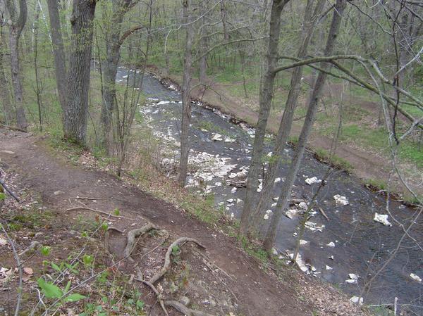
| ThankI went here without doing much research...as I started riding I had my doubts. But after warming up and finding some of the trails close to creek, I started having a lot of fun. It was a good combo of trails, some wide, some narrow, a couple of creek crossings, and many that were pushing you to the edge of the creek, (be careful not to fall in). As I rode next to the creek I saw a couple other riders across on the other side but didn't know how to get over there. So i found a railroad crossing that went over the creek. There was a great mix of groomed and un-groomed trails, a true mountain biking experience.
After reviewing the map when I returned home, I realized that I didn't even get to one half of the trail. So I have a good reason to come back.
| ThankGreat trail but poorly marked. If you have time to explore and figure it all out, it's a very fun trail.
| ThankRode here on 6-26-13 found some easy trails near a disc golf course. Came to find more trails 6-28-13 and found a whole different level of difficulty. Poorly marked, because of offshoots others have made you may make wrong turns. The more difficult section would be awesome if you could keep the flow because you knew the route. Crude jump area, crazy inclines through trees and drops down gnarly roots. Good time. Couldn't check in because the map decided to make the coordinates 00.0000000, 00.0000000
| Thank