
Most avid forest wanderers have a favorite mapping method for unknown trails, whether it’s an app like the Singletracks trail database or a trusty folded paper and compass. Nearly all trail mapping software uses open source data from Open Street Map in one form or another to help folks plot their course, while some sites offer far more than a list of trails and their related descriptions. With all of the data and user-generated trail descriptions online, it can be difficult to decide where and how to build a route. The developers at Komoot have simplified much of the process with the features included in their new premium offering.
With Komoot Premium, users can plan multi-day rides from point to point, looped, round trip, or flower-petaled around a central location. The software will chop a long multi-day route into manageable chunks based on your stated fitness level, elevation profile, desired scenic or tourist interests, choice of hotels or campsites, restaurants, and the level of difficulty or technicality you are up for. You can create a route that remains on asphalt entirely, or follows the most technical trails possible. There is even an “off-grid” option that allows you to find the way through areas where there are no known trails or roads.
Once your route is chopped into manageable daily rides you can drag it around the map to reroute through towns that you want to stop in or to take specific trails. You will also be able to see where hotels and campgrounds are located, where to find restaurants, and where to go for fresh drinking water. While you can certainly get lost in the backcountry with all of this tech, it makes the initial planning sessions a pleasureful experience.
Premium users can download maps and routes for offline use, and Wahoo and Garmin both play nicely with Komoot software to provide turn by turn directions on their devices. You can also follow directions on your phone, and even add a voice command if you don’t mind noise in the forest.

Elevation profile from Cervinia to Zermatt. Types of terrain along the way. Fortunately it will be warmer in August.


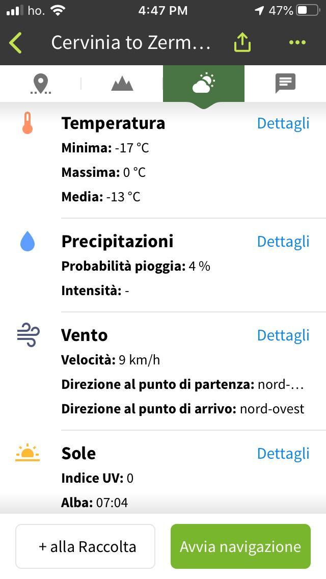
This summer I plan to ride form the Italian side of the Matterhorn in Cervinia to Zermatt, Switzerland, to photograph the final round of the 2020 Enduro World Series. I have ridden a bit around Cervinia, and it looks like I’ll have to hike across a glacier to reach the descent into Switzerland. This ride will save me roughly five hours of driving, so I’m happy to carry my bike for as long as it takes.
I used Komoot on my laptop to plan the route, and based on my stated fitness level and desired level of technical riding, the software says it will take me 4 hours and 3 minutes to travel the 24.1 kilometers, with 1,300 meters of ascent and 1,700 meters of shred. That’s with an average speed of 5.9km/h which seems accurate considering the slippery hiking. The software further describes the ride by showing how much of the route is singletrack, what amount is designated “trail,” and how much asphalt will be involved. Fortunately, only 327m of my ride is on pavement, so I’m stoked.
The ride is now saved in my phone where I can download the maps to help find the track as the cellular signal fades, and I can share it with any friends who decide to come along. I will also load the track into my GPS device and bring a paper map of the area. Stay tuned for a full writeup on Matterhorn riding, and a photo essay from the race in late August.
Users can download the offline maps alone from €3.99 to €29.99 depending on the map, or opt for the premium version for €59.99 annually. So, while the snow continues its piling and melting cycle and fruit trees pop their full blooms, get out and plan some adventures!


0 Comments