

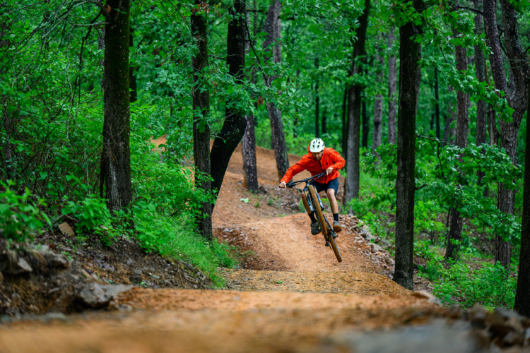
By now, most core mountain bikers have ridden in Northwest Arkansas. The name “Bentonville” is on the lips of riders across the country, and the trail building hot spot has cemented itself as a mountain bike mecca.
Even though you may have ridden in Bentonville already, the state of Arkansas has so much more to offer mountain bikers than merely its northwest corner. Following Bentonville’s lead, towns across the state have begun building incredible mountain bike trails of their own. Today, Arkansas is blanketed by fantastic singletrack, and the scene just continues to get better year after year.
My latest visit to Arkansas marked my fourth time riding in the state, so I decided to go on a quest to uncover the best new trails built in the last five (or so) years. I drafted my own list of possibilities, but as I talked to locals and consulted experts, the list of new trails to explore kept getting longer and longer and longer.
Eventually, I had to cull down the list to just the cream of the crop. With so many to choose from, I identified not merely a slew of new trails, but a collection of five fantastic mountain bike trail systems built in recent years that are well worth returning to Arkansas to ride!

Horseshoe Canyon Ranch, Jasper
“If you come in there and look at it, it’s boulders everywhere.” – Gary Vernon
- Total mileage: 20 miles
- Difficulty: Intermediate to advanced
- Completed in 2025
- Highlights include technical downhill trails, especially Mangled Mullet and Safety Meeting, and on-site camping and e-bike rentals
Horseshoe Canyon Ranch (HCR) is one of the newest trail systems built from the ground up in the state of Arkansas. As of press time, phase one of trail development, totaling about 20 miles of singletrack, is nearing completion.
HCR began life as a dude ranch, and then became a rock climbing hotspot thanks to its soaring cliffs. When the original owner was looking to retire and sell the property, several private parties were interested in acquiring the land, which would have eliminated public access. The Waltons, via the Runway Group, stepped in to acquire the property so that the public could retain access to this incredible parcel of land.
The 650-acre ranch is tucked away deep in the Ozark Mountains. The ranch lies at the bottom of a dramatic canyon surrounded by towering rock walls. The property boasts 850 feet of elevation change from top to bottom, with the best downhill MTB runs covering at least 650 feet of that vertical.


The all-new mountain bike trail system was designed and built from the ground up by Rock Solid Trail Contracting, and while there are one or two short beginner-friendly green trails, the singletrack here is raw and rugged.
“When we were looking at building a trail, I made sure that [everyone] understood that this is not going to be a Bentonville, All American beginner experience,” said Gary Vernon, Director of Outdoor Recreation and Trail Innovation for the Runway Group. “If you come in there and look at it, it’s boulders everywhere. There’s no flat part of this property. It’s either going uphill or downhill.”
Rock Solid capitalized on the endless boulder field to build a series of gnarly, rock-strewn downhill runs featuring massive rock gardens, ledge drops, rock rollers, and even a massive slab roll that’s roughly 20 feet high. Of course, you can find one purpose-built jump trail as well… but the token jump run stands in stark contrast to the endless chunder.
The steep grades on the ranch led Runway and Rock Solid to design the trail system around e-bikes. At the Bike Barn, visitors can rent an e-bike from a massive fleet of Specialized Turbo Levos.


While HCR might be remote, once you arrive in the valley, there’s no need to leave. Park your van or pitch your tent in one of the two campgrounds, or rent a cabin. The general store sells essentials, and a restaurant on-site will keep you well-fed.

Pinnacle Mountain State Park, Little Rock
The best all-around trail system in the Little Rock region
- Total mileage: 19
- Difficulty: Beginner to advanced
- Completed in 2021, with updates in 2025
- Highlights include the Chaotic Zone jump trail, rock gardens on Turkey Tracks, and views of the Arkansas River
Pinnacle Mountain State Park is one of four “Monument Trails” built in Arkansas State Parks. “It’s a collaboration between Arkansas State Parks, the Parks Recreation Foundation, and the Walton Family Foundation,” said Matthew Friant, Park Interpreter for Pinnacle Mountain. “They’re implementing multi-use trails at a couple of different parks that have the best terrain […] with new parks to come in the future for bike trails that incorporate really good, world-class mountain biking opportunities, everything from green- to black-level trails.”

Pinnacle Mountain is one of the newest Monument Trails, with the bulk of the trail build completed in late 2021. However, two of the trails in the park — Chaotic Zone and Middle Mountain Run — were entirely rebuilt in January 2025 by the trail crew from the renowned Highland Mountain Bike Park in New Hampshire. The original trail system buildout was completed by Jagged Axe, Rogue Trails, Natural State Trails, and Affordable Trail Solutions, according to Friant.


Following the rebuild, Chaotic Zone is now widely regarded as one of the best trails in the park. This manicured jump line features perfect flow, with fantastic tabletop jumps, shark fins, sweeping berms, and a few big doubles. While Chaotic receives a black-diamond rating compared to other trails in the park, it’s more accurately ranked as an advanced intermediate jump line than a true black-diamond line. Regardless of the rating, Chaotic is a crowd-pleaser and is unequivocally the best jump line in Little Rock.

Local riders all agree that Pinnacle Mountain is also the best all-around trail system in the Little Rock region. This expansive network truly covers the range of difficulty, with trails from beginner to advanced.


In addition, Pinnacle offers plenty of raw, rocky lines on trails such as Turkey Tracks, Twistflower, Glade Runner, and Carnasaw. While a few of the trails are downhill-oriented, there’s enough mileage to stretch the legs and get in an honest pedal ride. Couple the fantastic singletrack with stunning views of the Arkansas River and well-equipped facilities, like a bike wash and repair station, and Pinnacle is often the first and last stop for local mountain bikers.

River Mountain Park Trails, Little Rock
City park with 10 miles of singletrack by the Arkansas River
- Total mileage: 10
- Difficulty: Intermediate to advanced
- Completed in 2021
- Highlights include Gravity Falls downhill trail and The Narrows XC trail
You’ll notice one name crop up repeatedly on this list: “Little Rock.” The state’s capital has been playing catch-up in recent years, and after six-plus years of concerted trail building, the largest metro in Arkansas has become another great weekend MTB destination in the Natural State.
River Mountain Park is located closer to downtown Little Rock than Pinnacle, and it, too, offers a great combination of both cross-country and downhill-oriented trails.


The Gravity Falls and Whirlpool downhill runs may be short, but they’re feature-packed. A few of the steep roll-ins and optional features on Gravity Falls earn it a black-diamond rating, although B-lines have developed around the hardest features. If you know where to look for it, you’ll also find a massive step-down drop on Gravity Falls, which is not for the faint of heart.
Whirlpool offers a more intermediate-friendly descent, with big, sweeping berms and mellow tabletops. While some riders will have a hard time carrying enough speed to clear the tables, with the assistance of an e-bike, it’s possible to kick up the right amount of speed to clear the hits.


For those who like to pedal, several parallel trails extend north along River Mountain, allowing you to crank out a series of long, narrow loops. One of the stand-out XC trails is The Narrows, and while it gets a black-diamond rating on most maps, the few rocks are simply entertainment — this is more of an intermediate trail. The narrow, winding singletrack on this gem is well-worth a pedal.
River Mountain was also built by Rock Solid and was completed in 2021.

WOKA Whitewater Center, Siloam Springs
Hand-built singletrack at a world-class multi-sport destination
- Total mileage: 12
- Difficulty: Beginner to intermediate
- Completed in 2024
- Highlights include riding through a barn on Barnstormer and narrow, hand-built singletrack
Arkansas is leaning into multi-sport trail destinations. In addition to HCR’s fame as a rock climbing destination, the Waters of Oklahoma and Arkansas (WOKA) Whitewater Center near Siloam Springs is a world-class $30 million whitewater center that now offers just over 12 miles of mountain bike trails, too.
Not all mountain bikers are fans of the downhill-oriented flow trails being built across Arkansas. Some prefer a more pedal-forward experience that harkens back to the good ol’ days of the sport. WOKA provides that trail flavor, with miles of serpentine, hand-built XC singletrack traversing steep hillsides above the Illinois River. Instead of running straight up and down the grades, the singletrack hugs the sides of the hill, with some narrow pinch points and moderate exposure in places.


The choice to build old-school singletrack by hand was made very intentionally, according to Uriah Nazario, Director of Soft-Surface Trails for the Trailblazers. One “con of having this trail system outside of an urban area is that it requires long-term maintenance to fall more on the shoulders of volunteers, as our team would have a tough time logistically keeping a bunch of flow trails in tip-top form, and therefore we had to make sustainability a top priority. Although a mass of our tourism comes to ride flowy, jumpy goodness and various machine-built trails here in OZ, these trails require professional maintenance for proper long-term upkeep.”

While the WOKA Whitewater Center is technically located just over the state line in Oklahoma, the mountain bike trails straddle the border, with one trailhead on either side. On the paved bike path connecting to the mountain bike trails, you’ll pedal past signs welcoming you to either Arkansas or Oklahoma, depending on which direction you’re traveling. This trail construction was an incredible collaboration between multiple landowners, including the Cherokee Nation.
WOKA was also built by Rock Solid and finished in 2024.

Blue Mountain and Rattlesnake Ridge, Little Rock
Two connected networks, including advanced intermediate singletrack, plus a beginner downhill trail for kids
- Total mileage: 11
- Difficulty: Beginner to advanced
- Completed in 2023
- Highlights include the Dhu Drop beginner downhill trail and the “Farkleberry” feature
The construction of Rattlesnake Ridge, finished in 2019, launched a trail building boom in Little Rock. Rattlesnake was designed and spearheaded by Mitchell Allen and built by Affordable Trail Solutions. At the time, Allen worked for the Nature Conservancy, but he is now the Executive Director for the Arkansas Parks and Recreation Foundation.
Rattlesnake was Allen’s first trail design project, “and I like really technical trails, and so I built this trail system that was extremely technical, and then later realized, ‘Oh man, I’ve done the one thing you don’t do as a trail builder,’ like just build something for yourself.”


While Rattlesnake is undoubtedly rocky, the vast majority of the trails are, again, most accurately labeled as an advanced intermediate singletrack. The short network offers punchy climbs and descents, with plenty of rock features and extended wooden bridges. There are several optional features sprinkled along the trail which push the difficulty into the black-diamond range, with the “Farkleberry” standing out as the most prominent.
After subsequently building trails at Pinnacle and River Mountain, Allen and other Little Rock locals realized they needed to build a true beginner-friendly trail, as the region didn’t offer one. That’s where the Blue Mountain expansion came in.


Blue Mountain is tied directly to Rattlesnake Ridge, and by combining the two networks, you can easily create a loop of 12 miles or more. But for beginner riders — and especially kids — Blue Mountain can be its own ride.

The Dhu Drop trail is a beginner-level, downhill-only MTB trail that bisects the Luna Moth trail at Blue Mountain. This mellow descent features sweeping turns, low wooden bridges, and plenty of rollers for kids to play on. While Allen acknowledges that fully-grown riders may find the trail “slow,” you have to remember that it was designed for the kids. If you’re looking for gnarlier trails, pedal a mile or so over to Rattlesnake proper, and you’ll find what you’re looking for.
Affordable Trail Solutions was contracted to build Blue Mountain, and it was completed in 2023.

Even more new Arkansas trails
But wait, there’s more! Here are a few more new trail systems in Arkansas you’ll want to explore on your next visit.
Red Lick Trails, Clarksville
The new Red Lick Trails were opened in 2023 and offer a combination of downhill trails and cross-country pedaling. The downhill runs range in difficulty from green to black, but the black diamond trail — Raven — is home to some of the biggest and most intimidating features on a mountain bike trail in Arkansas. Rogue Trails made use of massive boulders and cliff bands strewn across the hillside to craft big rock slab rides and drops, all stitched together with wooden bridges.
Ward Lake Trails, Mena
The ambitious Trails at Mena project calls for the construction of up to 100 miles of new trail near the City of Mena, with chairlift infrastructure providing lift-accessed riding with 1,300 vertical feet of descending. While the chairlifts and downhill trails are slowly working their way through the USFS process, Progressive Trail Design has already completed the very first singletrack in the Trails at Mena project, located in the Ward Lake Zone. Situated close to the City of Mena on the southeast end of the proposed development, these first few miles of singletrack provide easily accessible mountain biking for local residents and will serve as a critical access point to the future trail system.
Craighead Forest Park, Jonesboro
Towns in the eastern plains region of Arkansas are also jumping on the trail-building bandwagon. The most substantial trail system development in the region is in Jonesboro’s Craighead Forest Park. While Craighead has long been home to a network of historic singletrack, the City of Jonesboro decided to revamp and expand the trail system with professionally-built singletrack. The city hired Rock Solid to build 13 miles of top-tier singletrack, which opened in 2024.


Parting thoughts
Over the past 5+ years, mountain bike trail development in Arkansas has expanded from the northwest corner to the rest of the state. We’ve seen the largest metro in Arkansas play catch-up, and now Little Rock is home to a slew of top-tier trails. Trail networks are popping up near towns from the Oklahoma border to the depths of the Ozarks, and even communities in the eastern reaches of the state are investing big dollars in pro-built trails.
One thing is certain: if you think you’ve ridden every trail in Arkansas, you’re dead wrong. By the time you think you’ve pedaled them all, a new slice of singletrack will have opened in the next town over.
What a beautiful problem to have!


2 Comments
Jun 20, 2025
Jun 16, 2025