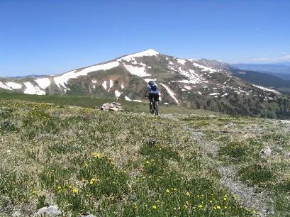
This epic journey takes you over the Ten Mile Range between Peak 8 and Peak 9 on the Wheeler Trail The ride has many technical sections, lots of climbing and a steep downhill that takes you for what seems forever down to Copper Village. From Peaks Trailhead in Frisco follow Peaks Trail [trail takes off on east side of parking lot] to Breckenridge trailhead .There is a trail that takes off on th other side of the road follow this trai a short distance until it ends at Peak 8 Base Area. From here follow Ski Hill Road down to Breckenridge turn right on ParkAv. to Village Road climb up a short distance. Turn left into the paved parking lot below Beaver Run Resort ride through the lot turn right on the dirt ski area axcess road that goes up peak 9. Prepare yourself for a 51/2 mile climb. Stay right riding under the quad chair there are spur roads on the right stay on the main road heading up.It gets a bit confusing with all the spur roads that connect with lift towers but the general direction is up and main road goes through the ski area. Twards the top of the ski area stay right and pass Peak 9 Restaraunt at the top of Beaver Run Super Chair just below timberline. As you leave the ski area boundry you can faintly see the switchbacks of the Wheeler Trail going up to the saddle Between Peaks 8 and 9 on your right. Climb some more switchbacks above timberline until you reach Wheeler Trail marked with a sign and rock carrin. Turn right and follow Wheeler Trail across the tundra taking time to enjoy the incrediable vistas. The switchbacks loom in front of you. Continue on climbing the switchbacks above the scree field. Hope you're not afraid or heights like I am. Just keep your eyes on the trail and take small sure steps to keep from slidding on the small rocks.[my shoes had no tread!!!] Once on top 12400 ft. you can see all the way down to I-70 and Copper Village.There are great views of the Gore Range and Ten Mile Creek all the way up to the Climax Mine. From here you have a seriously technical and steep downhill that has washed out alot in the last year. After a few nice rock drops that are like stairs the trail smooths out a bit and you can relax and fly the rest of the way down to Ten Mile Creek. Just before the creek turn right and follow double track about 1 mile to the bikepath turn right and follow bikepath back to your car


 1
1
Rode this from Breck, up the ski resort on dirt access roads, took a right on Wheeler trail and up the switchbacks to the saddle, then turned back around and rode Wheeler into the Crystal Basin, onto Burro Trail, and right back to where we started. The climb up the resort/road is a beast, no doubt about that. Taking Wheeler up to the saddle was really cool, with a hike-a-bike up the switchbacks. Riding down that hike-a-bike was awesome/terrifying. Then riding Wheeler singletrack into Crystal Basin was unreal singletrack! Above treeline, sidecut, silly-fast trail that ultimately gets more technical the farther down you get. Insane views up top, before the descent. Then riding Burro is a fast, kinda technical way to finish the ride (look out for hikers on weekends). Great adventure ride all around, and a big day.
| ThankI rode the portion of this trail between Mccullough gulch and a popular hiking trail just over the ridge, and that section was remote, very little traveled, and had a lot of hike-a-bike to gain the top. That said, it was a beautiful trail, and the remoteness and ruggedness provided a solitary trail experience that was just sublime.
| ThankIts mountain biking,there should be alot of climbing and the down hill is worth every grunt.Great high alpine singletrack,but a fairly long fire road climb to get there.The ride reviewed is for the wheeler trail north side.There is also a south spur to the wheeler trail that is a great high alpine singletrack decent that can be linked to the spuce creek and burro trails to make a great loop.Both sections of trail do drop very quickly and somewhat technical.However any fairly skilled rider should have no problem and have alot of fun.I do recomend starting somewhat early as you are above treeline for a good bit of either ride.
| ThankTo me, this ride turned out to just not have enough fun to justify the amount of climbing that you do. You spend a lot of effort to get to the top of the pass only to go straight down to the treeline, burning off lots of hard-earned altitude while sitting in the seat and squeezing the brakes. Once below tree line the trail follows the terrain more, but while it is a pretty fun downhill, it isn't anything special. Before you know it you are at Copper Mountain wondering why you spent all that time grinding your way to the top. If you like high-alpine adventures, or are into climbing, then this might be fun for you, but for me it just wasn't worth the effort. To get your downhill fix in Breck, head out Tiger Road and hit the Colorado Trail or the Red Trail, or ride down the Peaks Trail. Those are way more fun for the effort. Btw, the Peaks Trail now essentially dead ends at the trail head on American Way (the road up to Peak 8). There is development being done where the trail used to go on the south side of the road. You will need to take a right (uphill) and just go to the Peak 8 base area, or do some bushwacking to find your way thru on the Nordic Center trails.
| Thank