×

|
Rate it:
Tags:
Level:
Length: 12 mi (19.3 km)
Surface: Doubletrack
Configuration: Lariat
Elevation: +164/ -148 ft
Total: 5 riders
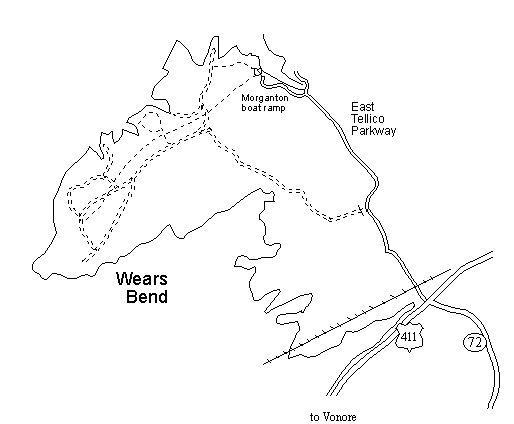
Mountain Biking Wears Bend
#156 of 205 mountain bike trails in Tennessee
A number of interconnected, gently rolling dirt (red clay) roads that cross fields and woodlands. From the boat ramp area, a dirt road follows the gas pipeline for 2.1 miles to a junction with the main dirt road that leads 3 miles to a gate on the main highway. Single track spur trails lead out to the edge of the lake.
First added by Rockinr on Nov 4, 2007. Last updated Apr 28, 2020. → add an update
Before you go
- Drinking water: unknown
- Lift service: unknown
- Night riding: unknown
- Pump track: unknown
- Restrooms: unknown
- Fat bike grooming: unknown
- E-bikes allowed: unknown
- Fee required: unknown
This trail information is user-generated. Help improve this information by suggesting a correction.
The Wears Bend Wildlife Management Area is located just east of Vonore off of US 411 on the eastern shore of Tellico Lake (Little Tennnessee River mile 18). Turn north on East Tellico Parkway across from the TN 72 intersection. There is a paved road to the west that leads to a boat ramp and the Morganton cemetery.