×

|
Rate it:
Tags:
Level:
Length: 7 mi (11.3 km)
Surface: Singletrack
Configuration: Out & Back
Elevation: -
Total: 3 riders
Mountain Biking Louise Lake
#159 of 272 mountain bike trails in Montana
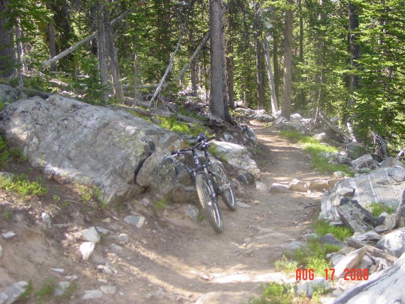
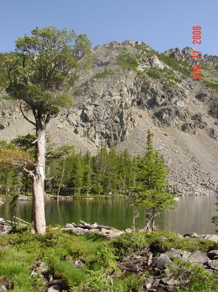
This is a designated National Recreation Trail for its scenery and recreational opportunities. I was told that this one is best left to the hikers but, having ridden it, I must seriously disagree; there’s some great singletrack here, fantastic views, not much in the way of crowds, and no user conflicts. I might not make the trip way out here just for this trail, but it makes a great add-on after riding the Lost Cabin Lake Trail with which it shares a trailhead. It’s just a little bit shorter with a little bit less elevation change. The climb is mostly non-technical, and remarkably consistent in its grade. Steep enough to get your heart rate up, but still rideable—a supreme aerobic workout. Unlike Lost Cabin Lake next door, which remains in the dense forest most of the way to the top, this one quickly ascends onto an exposed hillside with amazing, panoramic views of the Tobacco Root Mountains. The gawking will take your mind off the climb. If you want to practice switchbacks, this is the place to do it as there are many. The biggest technical challenge is the many water diversion projects—slabs of rock placed vertically across the trail—they’ll break your momentum going up and check your speed coming down. In spite of this, both the climb and descent are great, making this ride worthwhile, especially if you’re already in the area. The lake itself sits in a typical alpine basin. However, this lake is unusually deep and, if you’re prone to carrying a fishing rod, I hear this is a good place to bring it as there’s supposed to be some bigguns in there (second hand info).
First added by John Fisch on Aug 20, 2008. Last updated May 1, 2020. → add an update
Before you go
- Drinking water: unknown
- Lift service: unknown
- Night riding: unknown
- Pump track: unknown
- Restrooms: unknown
- Fat bike grooming: unknown
- E-bikes allowed: unknown
- Fee required: unknown
This trail information is user-generated. Help improve this information by suggesting a correction.
From I-94 about halfway between Butte and Bozeman, take exit 256 to Cardwell. Follow the road generally south and east—the road wanders a bit—just stay on the most obvious course. After about 6(?) miles, go right (south) on South Boulder Road. This will take you all the way to the trailhead. The first few miles are paved, but the road is narrow with sharp turns obscured by trees. Then, the road turns to gravel—some of it is kind of rough—continue to watch out for blind corners. Allow some time for this part of the journey as it can be time consuming, especially if you get caught behind a horse trailer. After about 14.5 miles on South Boulder road, it splits. If you don’t have a 4x4, this is a good place to stop. There is a large meadow where you can park and there is also a bathroom. Drive/ride up the right fork another 2 miles and look for the sign for the Lost Cabin Lake and/or Louise Lake trailhead(s). If you don’t have the 4x4, this will add 4 miles roundtrip to your ride, but it’s a good warm up to start, the scenery rocks, and the final descent back down the dirt road is just more fun to finish your day.


Directions are wrong in that its on I-90 between Butte and Bozeman, not on I-94.
| Thank