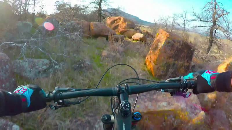
6 different loops of single track consisting of rock gardens, short steep climbs, fast rolling meadows, with several dry creek crossings. Restrooms are located at Lake Lawtonka School House Slough at the eastern trailhead, in the middle of Medicine Park, and at the Lake Elmer Thomas boat ramp as you enter the wildlife refuge on HY-49. Green and red loops have the most flow but are closed for hunting Oct. 1 thru Jan. 15. Blue loop is the easiest, but still would be considered intermediate level. Orange, yellow, and black loops are rocky, technical, and challenging with grueling climbs and boulders. There has been an additional 2 miles of trail added to the Blue Trails in 2021 and they are being currently being improved. There are now 4 Enduro type Down Hills with some decent drops & jumps (bring your full face helmets). The orange, yellow, and black loops are rocky, technical, and challenging with grueling climbs and boulders. out the trail map at www.medicinepark.com.


 13
13
One of the best trails in Oklahoma. You must go here but make sure you're in good shape first
| Thanklikey the cta-3 track
| Thankmore trail added and the area is beautiful place to ride ( if you like tech you will be happy) and has that west USA vibe - one of my fav"s
| Thankgo fish for the win - great addition- this zone is must ride
| Thanknew fish trail!
| ThankAlways like riding in the Park
it rocks!!!
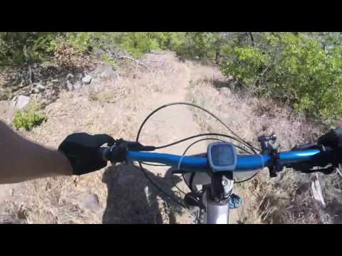
Rode the east side from the trailhead. Lots of fun tackling the field rock and rocky sections in the woods. Trail is rutting in some locations and a little clearing is needed. Trail layout provided smooth sections, short steep climbs, twists and turns, and plenty of rock to negotiate.
| Thanktrailhead on topo map is incorrect. trails are in medicine park on Lake Lawtonka. I am working to update this topo map.
| Thanknice place to have a cold one and hike and can't wait to bring my bike!!!
| ThankMedicine Park is a great little 'must-see' community. The locals at Base Camp are a friendly & active bunch. Beautiful views of cacti, rock formations & lake. Respect the rocks, be safe, & have a great ride.
| ThankFirst time visitor here 4/15-16. Beautiful setting and cool little place (Medicine Park). Very welcoming local riders (Mark and buds at Base Camp)! Tried east trails and found they were a bit much for intermediate riders. West trails were a little damp but we were able to ride Blue, upper hillside trail of Green and Red loop. Highly recommend central south riders to go to these trails.
| ThankAlways liked hiking in the area but know I really like riding here- love the dirt and rocks:)
| ThankReal deal MTB here - great scenery and vibe down in the park
| ThankGreat trail - beautiful area and the trail has hard pack flow and if ya want to rock rodeo - its all thereðŸ'
| ThankMy first time to Lawtonka trails and I'm an experienced biker but new to mountain biking. Loving everything about it so far. Unfortunately, I do not have any trails locally so this is the closest to my home (1 hour drive). After not paying attention when I arrived to Medicine Park, I took off on the orange trail first. Made about 1.7 miles in and quickly realized it was beyond my skill level. I ride a 29 hardtail and I probably walked almost half a mile of my short time on the orange trail. I can tell it will be fun and challenging as my skills progress. I'll get back out there someday but hopefully on a FS. So...I loaded back up and went out to the west trails. I found the TH to the green loop (West Shore Trail) and got busy. I found this trail still a little ahead of my skill level (maybe not skill, but stamina) but I made it through the entire loop whilst walking maybe a half mile of it. My map said the loop was 4 miles I believe it was, but when I finished back to my truck, my strava indicated I rode around 5.1 miles. Either way, I had a great time and challenged myself which is what I'm am always looking for. Some nice little rock gardens and short, steep descents and climbs. Roots and rocks all over, and I felt that once or twice I may have veered off the trail, but quickly found my bearings and got back on track. I very much enjoyed this loop and am looking forward to getting back as soon as possible to run it again. Oh, and I have not had the chance to meet the Base Camp folks yet, but I really wanted to give them props for maintaining these trails. I know it takes a lot of work and I applaud them for their dedication to keeping the area active.
| ThankUPDATE!
Since my last review. I am now a resident of Lawton, OK and ride the Lake Lawtonka trails on a regular basis. Let's talk about the East Side trails. This is where all the real fun is at!
From BASE CAMP - climb the dirt road (S Parkway Ave.) behind the Old Plantation restaurant for about .15 miles and you will find the start of the Black route switchbacks (AKA EAST LOOP). This "trailhead" which is not technically marked as a trailhead is kind of hard to find, so at the "T" of the dirt road (where it meets Merry Circle Dr.), turn left and look for the opening in the brush to the right. Basically look right for the climb. BEAR mountain is what this gem is called. A steady climb of switchbacks over very rocky terrain will take you to the top. A rewarding view of the town and lake. The black trail is really fun to ride for the next couple miles. It branches off in a few spots so it is easy to get off onto an adjacent trail. For the most part, black trail will take you along the ridge. short descents, quick climbs, lots of rocks and technical trail. As you ride there will be a trail that veres left and down a hill to meet up with BIG ROCK road. This is Petes Pass Trail, it is a connector trail from Black to the Orange and Yellow trail side. But if you don't hit Petes Pass, continue on Black around to a big set of rocks known as the Crag. this is where the trail will turn back on itself and parallel back in the direction you came from, just a little bit off the side. When you get to another split in the trail, you can continue right for the main trail or turn left to find yourself bombing down what is known as "Rollie Pollie". A huge smooth rock face that is a blast to ride down. The only drawback is that it has a gnarly climb out back to link in with the black trail. From this point you will be on a steady technical downhill section known as "ITCHY SCRATCHY". Riding this section is almost as fun as watching an actual episode of the itchy & scratchy show! You will end this run at what we know as "Bus Camp". A small MTB Clubhouse at the base of Merry Circle Road. Cut right out onto the gravel road for a short climb back to the "T" intersection you were at earlier and you know where to go from here. Back up the switchbacks! Or if you are spent, turn left at the Bus Camp to meet up with the main town road (East Lake) and head back into town. it will take about two minutes.
More to follow on the other East Trails in future reviews!
| ThankI'm an experienced rider, 47, with a home-built 9-speed 29er. I rode the trails on the west side of the lake July 3rd, 95 degrees, and here are some (hopefully) good tips:
-Before you start, check out the large map outside the bike shop on the Town of Magazine Park's main road. Take a pic so you can reference it on the trail.
| Thank-the trailhead is west of town off 49, just inside the Wildlife Refuge, about 50 feet past the first cattle guard, on the right. Parking seems safe enough, but no shade.
-the first mile or so is extremely brushy, more so than you have probably encountered. Just keep pedaling and follow the narrow break in the grass in front of you. Once you're through it, the trail is well-marked and easy to follow. There is one ramped, gated fence crossing.
-the majority of the route (blue, green, and red loops on the map) is very rocky- it's the kind of trail 29ers were designed for. Standard 26" tires will struggle somewhat, especially if the tires are narrow. Mine are WTB Prowlers, 2.1, and they worked perfectly.
-this is not a fast trail, especially the last third, consisting of the red and green loops; instead, the fun is in the technical aspect.
-The red loop is very up-and-down, all creek beds and gullies. In wet conditions, all three loops are probably not a good idea.
Keep your hand on the break, your eye on the rocks, and know when to get off and push, and you'll have a nice ride!
Lawtonka trails are a pleasant change for us flat landers. Definitely a good range of climbs and descents. At the same time will challenge your balance and choice of lines. Kiddos to mountain bike club of the Wichitas for a great trail and a ton of fun.
| ThankThis is a challenging trail system with climbs and significant rock features. Great scenery and the town is fun as well.
| ThankGreat trail system. If you look at the map, you will see basically seven trails. Look for Colored Arrows on the trails that mark them. These are considered by the locals as east and west side trails. They all have thier specific local names like plumbers crack, soup line or hamburger hill, but for the purpose of this review I will refer to them in East and West. Lets start with this. Go into Medicine Park and Visit BASE CAMP (580) 574-8955 ask for Mark (check it out on face book or google them) . A small Mountain sports Shop located in the center of the heart of Medicine Park. Mark runs the shop and is assisted by Chad and a wide variety of locals that are all hands on with the hang out, trail maintenence and general operations of building the mountain biking community. I haven't found a single person here that is stand offish, every face has a smile and is willing to talk local trails and shops. If you start and stop at this location, your car is in a safe area and you will finish in a location where you can eat a fresh buffalo burger, brisket burger or Ribs and a cold beverage.
Lets get to the West Side. You can start in town and ride to the main road to enter ath the trailhead off of the main road just a quick 5 minute ride away, but lets start from the shop. Ride towards the DAM (about 1/4 mile up the road from Base Camp). Walk over the Dam and you will start at the Blue trail (1 of 4 on west side). A great start with short climbs, some rocks and obsticles along the trail and opportunities to get your sea legs for riding over the rocks. It may beat up a hardtail, but I rode this trail with a young man that had a BMX bike. (I was impressed att his dedication to continue, he never gave up). Not a beginner trail by any means, but a beginner can ride this trail. They will be challenged. Rock, roots, some soupy areas, short climbs, short descents but a good loop. Blue trail (maybe 1.5 - 2 miles total) works into Green trail (2 of 4) that goes for an almost 4 mile loop with a break off to red trail at the apex. Green has several open and smooth singletrack areas with several rock garden areas that are spread out just enough to keep it interesting. Green trail turns and doubles back at the 2 mile mark and follows the fence line of the wildlife refuge back to the start (other trailhead that was mentioned earlier in this review). The trail follows the fence pretty close and sometimes too close so watch your handlebars. There are some pretty cool rock gardens on the return route! Lets talk about the Red trail. (3 of 4). So if you were riding Green, you will see a point where the arrow markers change color to Red. Two miles of another very good loop. Several area that are challenging with some steep short rocky climbs that will really challeng your ability to climb over terrain while turning in tight corners. Some pretty fun drops along this trail. You can't get lost on this trail because it doesn't cross over or switch back on itself. There are some plans for the locals to expand this system to encompass the entire lake and returning to the East side trails for a full loop of the lake. West side is closed from October through January for Hunting, which is why the locals really put alot of effort into building the East side trails. The last trail on the West side starts at its own trail head just inside of the wildlife refuge. It is a firebreak road that runs around the base of Mount Scott. It has been recently worked on and now provides a smoother ride compared to when I rode it six years ago. It is a smoker of a trail. Six miles one way from end point to end point. oth at hard ball roads. You can return the same route for a 12 mile ride or ride back via the hard paved road for about the same milage.
EAST SIDE: I have only riden two of the three trails on this side. Yellow and Oragnge (1 & 2 of 3) are great trails that use alot of the side of the hills to include several switchbacks and rocky climbs and descents. Not many smooth spots on this side of the trail system and not recommended for the beginner. This trail may claim several components as it is rough on both the body and your gear. Just look for the trail markers, this side has several post with arrow markers that will show you the way. A great ride and a smoker. Locals will love to show you the trails here as they take great pride in them. Alot of hard work has gone into building these trails. BLACk trail (3 of 3 ). I have not experienced this trail yet, so I can't really give you a review. I have heard that this is the mack daddy of the trails. Big Boulders, Big drops and some very technical and difficult trail to ride. For the experienced rider. i will hike it before I bike it so I know what I am getting myself into.
Enjoy and remember to look BASE CAMP up and visit while you are here.
| ThankThe guys at Basecamp are doing a great job on maintaining and expanding the trails. There is something for everyone although there is a lot of advanced rocky terrain. If you MTB, this should be on your list in OK.
| Thank