×

|
Rate it:
Tags:
Level:
Length: 5 mi (8 km)
Surface: Singletrack
Configuration: One-way
Elevation: -
Total: 1 riders
Mountain Biking Greenhorn Mountain Rd / GMR Downhills
#1,190 of 1,429 mountain bike trails in Colorado
Greenhorn Mountain Road (GMR) Downhills
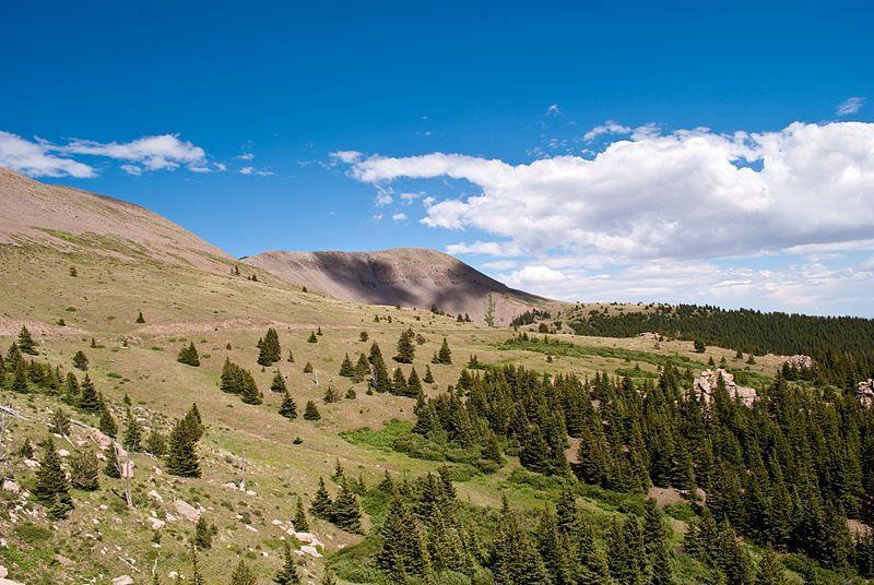
Four trails leave their upper trailhead at around 11,000 ft along the high-altitude Greenhorn Mountain Road (GMR) and drop 2-3,000 ft in 5-10 miles to a lower trailhead at the Lake Isabel Recreation Area. The GMR follows the crest of the Wet Mountains south toward the range's highest point, Greenhorn Mountain (12,347 Feet). The lower trailheads are scattered in and near the Lake Isabel Rec Area as follows: the Cisneros trail and the southern end of St Charles Peak trail pop out near the Spruce and Ponderosa Campgrounds at the back of the Lake. The Snowslide trail spits out at the entrance to the Rec Area, just off of Hwy 165. The north end of the St Charles Peak trail ends about 4 miles north of the Lake, at the Hwy 165 trailhead (for an epic day, continue down South Creek trail to Pueblo Mountain Park).
Lake Isabel Recreation Area ($4.00 daily entrance fee) is approximately 30 air miles southwest of Pueblo, off of Highway 165. The 35-acre reservoir is tucked into the Wet Mountains at around 9,000 feet, and is a popular summer destination for fishing, camping and hiking. Numerous trails leave the Lake and climb the surrounding mountainsides, eventually intersecting the Greenhorn Mountain Road at around 11,000 ft. Leaving a car at any of the Lake Isabel Recreation Area trailheads, you can a shuttle to the top of the trail along GMR and enjoy thousands of feet of excellent and demanding descending on steep, narrow and usually extremely rocky trail and pop out at your stashed vehicle. The trails drop through dense, moss-covered pine forests that are more akin to a PacNW landscape than the arid, high-desert plains just 15 miles to the east. There is abundant camping at established NF and Lake Isabel Recreation Area campgrounds, as well as numerous primitive camping options along the many old logging roads that branch off the GMR. The listed trails are just a small sample from the many miles of trail in this region, with some trails dropping more than 3,000 feet from GMR to a lower trailhead.
First added by gatzke on Aug 31, 2008. Last updated Apr 28, 2020. → add an update
Before you go
- Drinking water: unknown
- Lift service: unknown
- Night riding: unknown
- Pump track: unknown
- Restrooms: unknown
- Fat bike grooming: unknown
- E-bikes allowed: unknown
- Fee required: unknown
This trail information is user-generated. Help improve this information by suggesting a correction.
DIRECTIONS: The main access to this area from the north is Interstate 25. From Pueblo follow I-25 south for 25 miles to Hwy 165 (exit 74 - toward Colorado City/Rye). Travel west on Hwy 165 for approximately 20 miles to the Lake Isabel Recreation Area.
There are four trailheads in the Lake Isabel area, three of which are located at the Recreation Area with the fourth just north on Hwy 165. Cisneros Trailhead is located within the recreation area (across from Spruce and Ponderosa Group campgrounds). The southern end of St. Charles Peak Trail links up with the Cisneros Trail within a half mile of the Cisneros TH. Parking for the northern St. Charles Peak Trailhead is located approximately 4 mi north of the entrance to Lake Isabel, on the east side of Hwy 165. Snowslide Trailhead is located at the entrance to the Lake Isabel Recreation Area, just off Hwy 165.
To reach upper trailheads (along Greenhorn Mountain Road aka FS Rd 369):
From I-25, take exit 74 toward Colorado City/Rye. Follow Hwy. 165 west for approx. 25 miles to a left (west) turn on FS Rd. 360 at the turnoff for Ophir Creek Campground, just north of Bishop's Castle. This turnoff is in the "town" of Fairview.
Travel FS Rd 360 for about 12 miles to the four-way intersection with FS Rd 634/Gardner Road (straight) and FS Rd. 369/Greenhorn Mountain Road (left). Turn left on FS Rd 369/Greenhorn Mountain Road.
St. Charles Peak TH: Take GMR a little over 2 miles to where an old logging road takes off to the east (left). Most vehicles park in the large, signed trailhead parking area before the fence/gate, as the old logging road peters out after about a mile (though high-clearance will get you to the top easily).
Cisneros TH: Travel GMR for about 9 miles to the trailhead on the left.
Snowslide TH: Continue on GMR a short ways past Cisneros TH to a signed left turn for the Snowslide trailhead.