This IMBA epic is acclaimed as being one of the best MTB rides in the Country. The ride starts at the 18 Road Bookcliffs Recreation Area and takes you high up into the Book Cliffs. This is a big ride with a waterfall portage .With all the options you can mix up the start and finish any way you like, but the route should probably be ridden clockwise.
Well I finally did this ride this spring. I started at the upper parking lot down Kessel Run to Western Zippety (a pipeline road) to Frontside Trail to Coal Gulch Road. This section is typical Bookcliffs. Ya gotta love it! RIDE UP Coal Gulch Road stay right at the fork and CLIMB STEEPLY to the top!! This is a long climb up a dirt road. Follow the road on the ridge top heading south. There are many spur roads Stay on the ridge top . You will pass a pump station that is always running. I was able to find some bicycle tracks to let me know I was heading in the right direction. Keep straight on the ridgeline. The road turns to double track . This is a fun rolling section with some short climbs Just as the trail starts to drop down the 2100 ft. decent there are great views of the Grand Valley. Next there are a couple of really steep downhill sections. Turn right on the single track down to the wash. This downhill was tight , twisted and fun! Ride down the wash if you can. When you reach the waterfall hope the rope is in good shape! At the bottom of the waterfall continue down this difficult wash .Look for the trail that parallels the wash crossing it several times. Itís a toss up which way is easier! Watch for the singletrack out of the wash. After about four challenging climbs (that pushed me to the limit!) turn left on the road follow this road about a mile turn right when you reach the singletrack , ride past the corral up one more hill to the lower parking lot and back to camp. What a ride! Route finding wasnít difficult but you should probably take a map.


This is an absolutely awesome ride. I'd advise anyone doing the IMBA epic ride on this app or on MTBproject. Some of the trails have been rerouted or aren't on the map. One major factor to take in consideration is the wind. The first time I rode, this never crossed my mind. The second time I rode it, I had to lean in to the wind to not fall off the trail on some of the narrower sections. Overall, a great trail with a lot of variation throughout the ride.
| ThankThis is one of those trails to ride and say that you did it. Nothing really great about it... It has long climbs along gas line access roads with little to no shade. Bring plenty of water (2 bottles camelback). After climbing approximately 3600ft to the top, the downhill is a steep loose mess. Once you tip toe down, you have miles of deep sand to ride through on your way out and back to the parking area. The views from mile 14-23 are not bad, but there are plenty of better trails in the area if you are looking for a 30mi ride.
| ThankWas snowy and muddy at top on 3/24/2014. Only passable because the mud was still frozen after a cold night. More back country adventure than the buff single track Fruita is known for. Great views. Steep descents. Challenging.
| ThankNone of the people that work in any of the local bike shops have done this trail, but they were keen on warning us away from it. It is definitely a long, epic that you have to put a lot of work into. It's not the buttery smooth single track like the rest of 18 Roads. It is worth doing, however. Be prepared for ass kicking madness.
| ThankAn awesome and challenging trail. A cross country type trail for sure....Better to be in decent shape before tackling it. Did it solo one time in early spring....still snow at the top and i had to post hole to reach the other side.* Review edited 10/12/2012* Review edited 10/12/2012
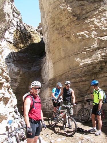
| ThankThis loop was not very well marked and, when ridden clockwise, the descent had some portions that were very steep and very loose. Still the scenery was awesome and it is a true adventure, especially in the section you have to rappel with your bike. Bring lots of water and consider going with someone who knows the route on your first visit. Allow a lot of time. It is a brute!
| ThankThe Edge Loop is a great trail that I do once a year. The ride out to Coal Gulch Road is sweet singletrack. Coal Gulch Road and the grind up the backside of the Bookcliffs takes an hour and isn't as horrible as some say. On top, the views of the Horse Mountains to the north are great and the view of the Grand Valley to the South are worth the ride. The last couple of years, Lippan Wash has been in great shape (i.e. not sanded out) and alot of fun to ride (overgrown branches to dodge with lots of rock to manevuer and ride across).
| ThankThis loop is pretty long, so get ready. The road riding is whack with a long ass uphill section, by the time I got to the top elevation I was dogged out, making the downhill much less enjoyable. While the climb is a good test of your fitness level, a shuttle up and around the back side would be the way to go. Also, once you get to the bottom of the Book Cliffs the uphills in and out of the wash were way to steep to ride and really broke up the flow. I might do this one again at the end of the season to see how I handle the climb, but it really wasnt as fun as lapping the front lines.
| ThankI thought, coming from Michigan, that this was a pretty fun ride. Not so technical but just a fun day ride with a mix of interesting terrain. It's not every day that you get to rappel down a waterfall or have the option of bunny hopping a free range cow sleeping on the trail.
| ThankIf you like riding on gravel roads then this trail is for you. The trails at the bottom... zippity, prime cut, chutes and ladders are way more fun. It was some excellent PR to get this trail rated as one of the best in the country and it is sad that this is the namesake trail of the fruita area with so much else the area has to offer.
| ThankThis is one of the best cross country rides in the country. The slate rock offers stair step climbs and canyon top curves surrounded by incredible scenery. This should be on the short list of any mountain biker.
| ThankThis is a great trail that has a little of everything. Climbing on dirt roads, technical 4x4 road descending, amazing singletrack aand breathe taking veiws. This probably is not the best trail in Fruita but defintly a must ride if you go. The only problem with this ride is the 2 miles of riding in a dry creek bed filled with gravel. But even with that it is still fun.
| ThankI have often wondered how this ride ever got on the IMBA epic list. With something like 17 miles of road riding its hardly my idea of a singletrack dream. I suppose after too many beers with Troy you can be convinced of anything. In any case, the frontside singletrack to Coal Gulch is a lot of fun (even though much of it can be experienced by riding Zippety). The downhill is a lot of fun, but not enough for me to justify the long grind to the top. Note that after you come out at the bottom of the gulch and run into double track you should go *right*, uphill, for a couple hundred yards to get onto The Edge Connector, which is a fun ride in itself, and much more fun than riding down to the corral. After riding the connector you can go down or up Chutes and Ladders. Like Lostcause says, pick up a map at an LBS -- it will make your life easier.
| Thank