


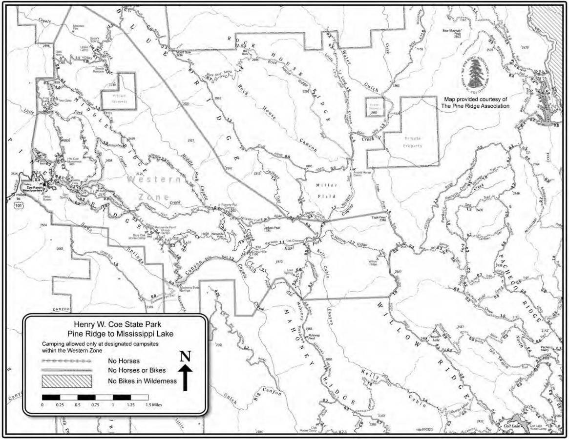
Middle Ridge is well known to locals, it's one heck of a single track and one of the few that you don't have to Climb 1500 feet or more for the pleasure of the descent that privilege waits to greet you at the end of the single track as you climb your way back out of the confluence of the various forks of the Coyote Creek. So as you come into the visitor center you'll note an asphalt road off to the left, all points start by climbing this 100 yard grind to the gate. From the gate follow the Manzanita Point Road a dual track fire road. Go a mile or so then as you drop into a saddle between ridges you'll note an information sign at a trail junction on the left. This is the junction of a series of single tracks. You want to go on the Flat Frog Trail the hard left of the three options. Flat Frog is a fun single track with wonderful views of the various ridge lines running through Coe just short of 3 miles it's an easy fun ride for anyone. Flat Frog drops you at Hobbs Road another fire road go left and cross the creek and begin a steep difficult climb of about 200 to 300 feet of gain. As you top out Middle Ridge a single track breaks off to the right, if you start a steep descent you've gone too far and trust me this part of the road is no fun to climb back out of. Ok so now you're on the Middle Ridge single track hold on for the fun. Middle Ridge is 5 plus miles of steep fast single track with only a few technical areas thrown in to keep you honest. Once you start there is only two legal ways out, back the way you came or the bottom at Poverty Flat meaning you have to climb 1500 feet, you can get in serious trouble on a hot day so... OK so you've had a great time on the Middle Ridge you've bottomed out at Coyote Creek/Poverty Flat now you have three options out.
1) The road most traveled is Poverty Flat Road a grinding fire trail that takes you back to and merges with Manzanita Point road, a tough joy less ride.
2) Cougar Trail, a grinding single track (no fun up or down) off of Creekside Trail (see below),
3) My Favorite China Hole Trail is also off Creekside.
So I hope I've convinced you to go China Hole finding your way can be difficult however. As you come off Middle Ridge stay on Poverty Flat Road South (if your grinding you way up you've gone the wrong way). Keep your eye on the right of the road a modest single track breaks off, this is Creekside Trail. Takecontinue South along the creek, eventually some portage will be required to get around some rather large boulders. Creekside will drop you into an open area of boulders and river rock where China Hole Trail crosses the creek. China Hole breaks off to the right and begins climbing (it's easy to miss China Hole and end up on Madrone/Soda Springs trail which is no fun on a bike). China Hole's a great single track, a series of switch backs in and out of the forest canapy with spectacular views of the South End of Coe (I'll be posting a ride that includes this in a down hill eventually). You'll top out on Manzanita Point Road and still have some significant climbing to get back to the vistor center.
Options: Below are a few options from my preferred route, read if you like.
Option 1) Monument Peak. Instead of Flat Frog Trail take a left off Manzanita Point Trail onto Monument Peak cutoff (Hobbs Road). This road begins as a grinding (walk it) climb that takes you over the highest point this side of Blue Ridge, it's a fun treacherous descent to the Flat Frog Trail Junction and then continue as described above.
Option 2) Flat Frog Lake Trail. This is a great little single track that is not legal for MTBs. However there is no sign on the upside X'ing out bikes. I spoke with a ranger about this fact once and he said that it's OK to ride up but not down (which makes sense). It is a much more pleasant ride up than Hobbs and intersects directly with Middle Ridge (You'll see the sign X'ing out bikes for the down side). You take the Flat Frog Lake turn off from Hobbs cross the dam at Flat Frog Lake and you can't miss the single track heading up the hill. Check with a ranger before taking this trail I'm sure the rule is enforced subjectively.
Option 3) Emergency Bailout. OK so you fall beak a wrist or destroy a derailuer half way down Middle Ridge. Fish Trail is an option out that I run and hike regularly. It's a great single track that MTB's are not allowed on but trust me, if you're humping it, it will save you a huge part of the effort. This will take you back to the trail junction at Manzanita Point Road.
Have fun and while Middle Ridge is a fairly popular trail you can get in trouble anywhere in Coe and end up waiting a long time before seeing another soul so take a friend and lots of water and fuel.

Loading reviews...View more