**FROM NOMAMBO.NET**
Spillway offers a variety of trails for mountain bikers and hikers of any experience level, from beginners looking for a scenic ride through the woods, to seasoned bikers looking for an aerobic and technical challenge.
Type of Ride:
Tight and twisty singletrack - river bed clay, some sand. Trail also has numerous features that include bridges and berms. The trail is very beginner friendly as all technical features have bypasses.
Length:
One complete loop approximately 5.5 miles. Directional arrows, trail names, and mileage signage are posted for trail reference and is intended to direct the rider in a CLOCKWISE direction.
Trail Description:
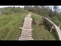
Beginning at the trailhead bulletin board (to the right of the park entrance near the front pond) you will ride through the "Headless Horse" into "Freesons" and the large pipeline right-of-way these sections are smooth, straight and easy riding all bridges/crossings are wide and easy to cross made up of wood & metal grating. Soon you will enter the "Wookie Wiggle" where the trail takes advantage of the terrain to make a twisty fun part of the course. Into the "Zephr" and "G.A.Z.Z." you'll experience tight & twisty roller coaster like terrain. Across a short wooden bridge to "Seinfeld" then "5 Minutes Alone" these sections are relatively smooth, straight, and fast. Pass the turn-around and into 'Up-Chuck" the trail becomes slower and more technical with moderate ups & downs (no significant elevation). Beware of Indiana Jones warning into "South Canada" where you will find the "8th Wonder Berm" and several others in a section of fast and fun turns. Soon there will be a smile from the spillway trail gnome into "W.D.D.A.M.F." & "Rat Tail" contain more twisty ups & downs with an assortment of berms and flowy sections. Soon you will be in the spooky "Ghost Trail" where you may encounter the unknown. You'll finish in the short section of "Chu-Chut" to the "FF Connection" which will take you to the levee climb and you'll follow the limestone road back to the park and trail head.
Events:
Several events are head at the trail every year. NOMAMBO host the annual cross country race the Spillway Scramble that is sanctioned by USA Cycling. The race is part of the Louisiana Mountain Bike Championship Series (LMBCS).
Another popular event open to anyone is the night time race affectionately called Race of the Dead. The Race of the Dead has become a Halloween tradition at the trail with sections of "haunted trail" where you never know what to expect.
NOMAMBO also host a yearly Time Trail series. The series is a fundraiser that allows the club to maintaining and improving the trail system. It is a fun competition that pits everyone against each other for one lap on the Bonnet Carre Spillway Trail as fast as you can! Entry fee is $10 and signup is done the half hour before the race starts. Awards include First (Men and Women), DFL (Men and Women), Lucky 13, the Pink Jersey, the Sand-Bagger Award and the Rusty Wrench!
The trail is also frequently used by running clubs for trail runs. Events like the Warrior Dash are held at the park and utilize sections of the trail.


Rode here back in February while visiting folks in NOLA. There's not much to this trail, and quite literally almost no elevation change. We were on the lookout for the wall ride, but couldn't find it. Seems like the river claimed it maybe. Even so this is still a fun ride. We only had time to go around once, but it must be easy to get into a groove here and start racking up the laps. This place gets extra points for close proximity to one of the great cities on earth.
| ThankI Just rode this trail today, it was really muddy but still a fun ride. However, I was disappointed because most of the wooden bridges and obstacles were broken, so you have to just skip whole sections of the trail. If those things were fixed this rail would have been pretty fast and fun.
| ThankI'm not kidding when I say we spent hours trying to find a shop to rent us mountain bikes in New Orleans. And guess what.. there isn't one. So instead of flying our bikes out to only ride a trail or two, we decided to grab mountain bike-ish bikes from Dick's Sporting Goods. When we tested these bikes out the night before the race, I knew we would be racing each other for last place. But I still stood by our decision to get those Nishiki's and wanted to go ahead and just do the race for fun anyways. Which is just what we did. The noise you hear in the background is the Norco plant. I'm not sure what it does, but we were told some horrible stories about the history of the plant which I won't go into here. Ok so the bikes were less than we'd hoped for, but how were the trails? This was the perfect course for a short, fun, cross country mountain bike race. The trail was flat and fast with some tight turns, roots, berms, bridges, and even a kewl drop that it killed us not to be able to try on the Nishiki's. It had rained the night before, so our tires were caked with mud that made it like riding on bald dune buggy tires through the trails. And I say the trails were fast, but we were obviously not able to get those bikes moving to experience that. There was something legitimately scary about being out there on your own encountering monsters and gouls as well as the random truck horn to scare the shit of you. NOMAMBO which stands for the New Orleans Metro Area Mountain Bike Organization - runs this race every year to raise money for their trail building efforts. So if you're ever in New Orleans for Halloween - be sure to check out this race. It's totally fun and for a great cause.
| ThankThe trail was great,it was well maintained and very clean.Theres a grass hopper that black and hugee.Nomanbo are doing a great job.
| ThankI was out in Louisiana visiting family and brought my bike for the stay. I thought I'd explore the local trails, and honestly driving to this place I had very low expectations! I knew the trail is almost at Sea level and it's in the flat and muddy boot of Louisiana. But to my surprise the trail is incredibly well built with tight turns with berms as well as some cool features. Sure, there's no technical climbs or descents to smash (I'm used to that out in Texas), but the trail builders really made fantastic use of the terrain they had. Pleasantly surprised and will be back again.
| ThankAwesome fun. Had no idea it was a Blue Square intermediate. For me it was a definite cardio workout. For my boys, they loved every minute of it. We will go back again and get there earlier. Well worth the hour drive. Thank NOMAMBO for keeping the trails clean and very well maintained.
| ThankFun trails easy riding. If you plan on stopping make sure you have insect repellant.
| ThankWell maintained. Great beginner ride for those looking to get experience.
| ThankIf you like going fast this track is for you as some bridges but a lot of speed well marked up and back
| ThankIf you're looking for big mountain riding this is not the place. To me, this trail is peaceful, it's in nature, a nice ride, and NOMAMBO is an excellent community. I recommend looping it multiple times, riding for time, focus on your cornering skills, and having a good time while not working! It is a great escape from the pavement of New Orleans.
I met some guys, re-enforcing a bridge, all of them were part of NOMaMBo and they were great to stop and talk to on my first experience. Thanks!
| ThankLove this trail!! Great flow. Berms are sweet and the guys down there keep it up well. Great place to ride.
| ThankWe rode this trail in the rain after the area received days of rain before our arrival. This trail is not challenging nor full of climbs and killer decents... know this going in and have an awesome time with the flat flowing portions of the trail. The builders have done a lot with little including woden bridges, banks, and berms. We got soaked and all came out smiling!
| ThankFun trail. Much better than I expected.
| ThankI really enjoy this trail probably best one close to home for me. It's not all that challenging there are are some jumps and one drop the trail is pretty clean and well kept just watch out for hikers and their dogs.
| ThankWell maintained trail that can be as tough or as easy as you want to make it. Very scenic with water views but be careful... the somewhat sandy track can be slippery at times.
| ThankThe Bonnet Carre Spillway Trail is built and maintained by the New Orleans Metro Area Mountain Biking Organization (NOMAMBO) and is located on US Army Corps of Engineers property. The area is part of a flood way for the Mississippi River. The flood way is not used every year and is controlled by locks at the river.
That land, for the post part, is as flat at it can be. There are small ridges, climbs and drops but nothing over 5 or 6 feet in vertical height with the exception of the man made levee. The trail is very beginner friendly but if you are an expert rider, don't let that fool you. The trail is filled with twist and turns that if you are not careful, will bite you with too much speed. The trail is has a number of features that include several berms, up and overs, tree obstacles, bridges, man made drops and rollers. While this trail, for lack of a better term, is flat, it is a very fun and fast ride with great flow. If you are in the area, don't pass up the chance to ride this little gem.
| ThankThis was a fun trail to ride. I was in the NOLA area on business, brought my bike, and decided to go for a ride. Nothing very technical so I think the blue rating should be down graded. Animals have been digging along several parts of the trail, crossed paths with an otter, so you have to keep your toes. Fun
| ThankFirst time I rode this trail and I had a blast. The trail zig zags along a small levee allowing for some down hill speed and up hill challenge. I got a good since of speed zipping between the trees. The jumps have side trails so you can avoid them if you wish. The trail is marked well which is good thing because of all of the turns.
| ThankGreat ride in the swamp.... Well laid out trail.
| ThankFun trail out in Norco La. Little over 5 miles start to finish with lots of tight turns and scenic sights. Few jump areas can be fun, if you know they are coming up ahead. At least 3 large burms were build recently along with some nice wooden bridges. This trail is always well maintained by local riders and members of NOMAMBO club. Great trail for a beginner or someone who wants to take the kids out for a ride, just watch out for the local riders as they like to fly through the trail! GO RIDE!
| Thank