

We had just three days to mountain bike as many trails as possible during our March visit to Northwest Arkansas, and the question wasn’t so much “which trails do we ride?” but “which trails do we choose NOT to ride?” With so many options spread all across this corner of the state, totaling hundreds of miles of singletrack, we had to be selective and choose only the very best. Days 1 and 2 had been a success, and based on feedback from the locals and our own trail research, we settled on Blowing Springs and Back 40 (“Back 40” for short) for our third and final mountain bike ride.
After twisting and turning through the maze of options in the greater Slaughter Pen complex, Back 40, in contrast, promised a lengthy 30-mile loop with minimal navigation required. Traveling north from the town of Bella Vista, on the map this loop really looks like it’s out in the back 40, with a portion of the trail rolling right along the Missouri/Arkansas state line.
After two long days of riding I opted to drive to the trailhead to begin the loop but my hammerhead friends, Nathan and Steven, decided to pedal there from our AirBNB rental. Theoretically we could have connected our Slaughter Pen ride all the way up to Back 40, creating a 50-mile epic ride, but splitting these various trails into two days proved much more manageable for my early-season legs.

The trails at Blowing Springs were flowy and well-built, with a gravelly trail tread that proved a bit slippery in the corners. After a few quick miles of tight and twisty we began working our way out of the compact trail complex. We were prepared for a backcountry ride, loaded with all the water and supplies we’d need for a long day. After all, the Oz Trails website claims that the Back 40 will “make you feel like you are in the middle of nowhere.”

But as we pedaled along, we passed houses just off the trail, and crossed roads every few miles. One section of trail skirted the very edge of a manicured golf course, with the singletrack located in a strip of trees a hundred feet wide separating the course and the nearby line of houses. I marveled at the ingenuity of the trail builders and the land managers who managed to approve singletrack in these narrow strips of woods. While I’ve ridden plenty of trails in such places, it’s rare to find a sanctioned trail basically in someone’s backyard.
Even Karen Minkel, Home Region Program Director for the Walton Foundation, acknowledged how unusual this situation is:
“Bella Vista (where the Back 40 trails are located) is a unique circumstance. There are a number of different organizations working to make those trails happen, whether they’re providing easements or managing the trail. It includes property owners’ associations, the city, and then a non-profit that we work with to construct a lot of the trails called the Northwest Arkansas Trailblazers.”
No detail, no matter how small, was overlooked when designing this loop. While in most suburban trail systems it’s common for the singletrack to dump out onto pavement for a quarter mile, or maybe even just a few hundred feet before picking up the next bit of singletrack, the coalition of partners that made the Back 40 a reality decided to make navigation as dead-simple as possible–just keep following the singletrack.
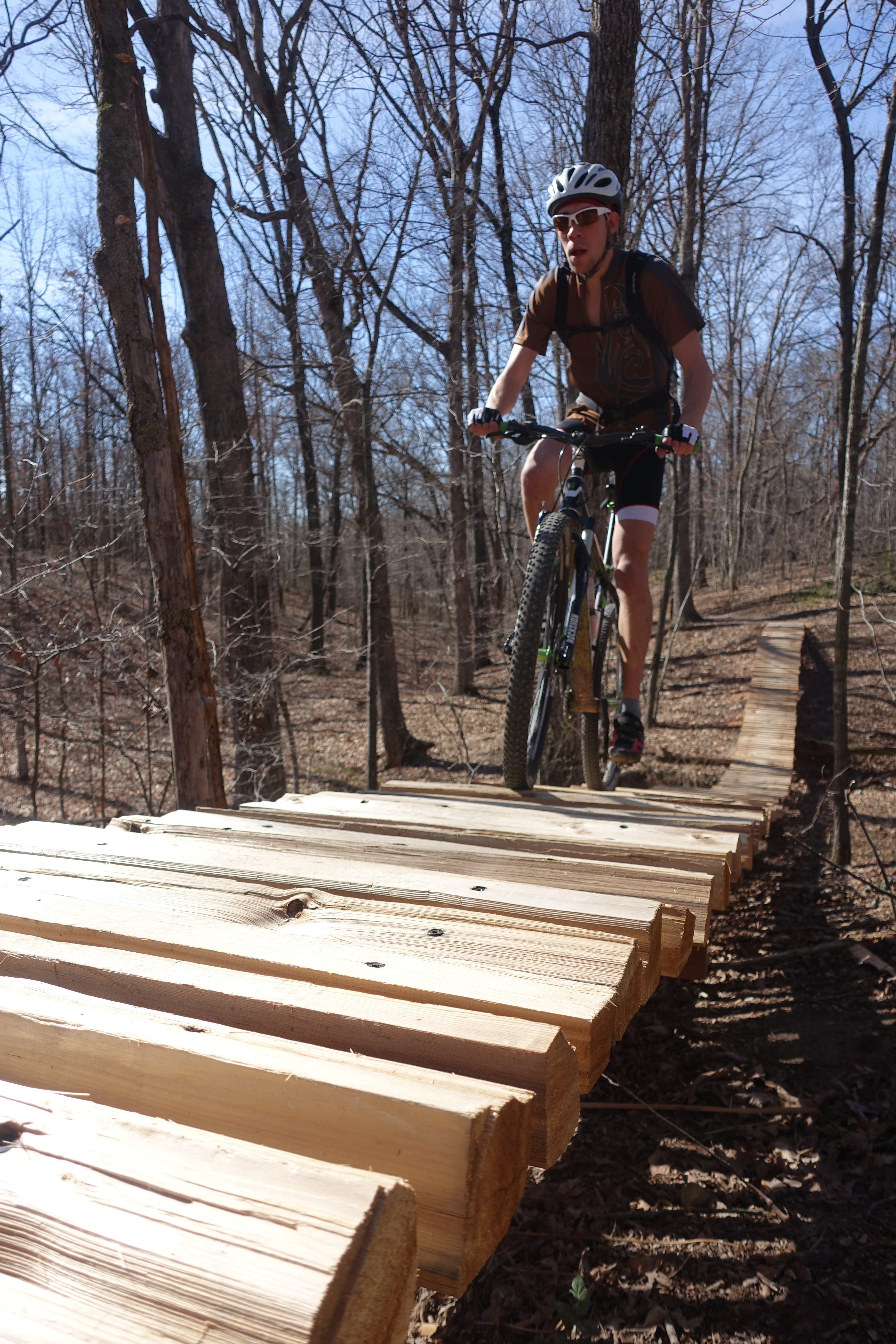
Even if the route follows a road for a half-mile, instead of just routing riders out onto the pavement, the trail builders instead cut rolling, entertaining singletrack right into the ditch. There is literally not one place where you have to follow the road–any road. If you come up to a road, just continue straight across it and back onto the singletrack.
At one point we did get a bit lost following a road around a turn and into a subdivision. But it turned out that the only reason we got lost is because we erroneously made a turn onto pavement, not seeing the continuation of the singletrack just on the other side.
The continuity of the singletrack in the Back 40 loop and the partnerships formed to make this trail loop a legal reality is admirable and a model that communities everywhere should emulate!

But as we continued swooping along the serpentine singletrack, that “middle of nowhere feeling” remained elusive. Sure, we eventually left the neighborhoods and traversed some larger swaths of woodlands, but without fail we’d reach a road crossing every few miles. Especially after mountain biking in the true definition of the middle of nowhere at the Upper Buffalo Headwaters just two days earlier, Back 40 felt pedestrian by comparison.
The trail tread itself felt pedestrian as well. If you’re an XC hammerhead and just want to bang out some miles, then this is the loop for you! Quality machine work, complete with sets of berms and rollers in random bits of backyard woodland, kept the trail interesting as the miles ticked off, but we could find nothing to challenge the technical mountain biker. Yet that speaks to the diversity of the greater NWA area–with Slaughter Pen focused on massive jumps and flow lines and trails like Upper Buffalo offering old school gnar, Back 40 will satisfy the true-blood XC riders. Indeed, we crossed paths with some obvious XC race teams out training–heads down and on a mission.

One optional trail came highly recommended from locals and online reviewers alike: the Ledges section. While you can easily bypass around it on a green section of singletrack, everyone we talked to raved about the incredible technical challenge, serious exposure, and sharp flint rock that was sure to slash any and every sidewall. One local friend, Alex Scoggins, told a story of slashing a sidewall on that portion of trail, fixing the flat with a tube, only to see another rider walking out of the same section of trail with a double flat, front-and-back, I questioned the sanity of riding such a section of trail. He assured me that it was well-worth-it, and to just ride cautiously.
As we continued along the loop we finally found the split that would take us to the Ledges, with this warning sign:
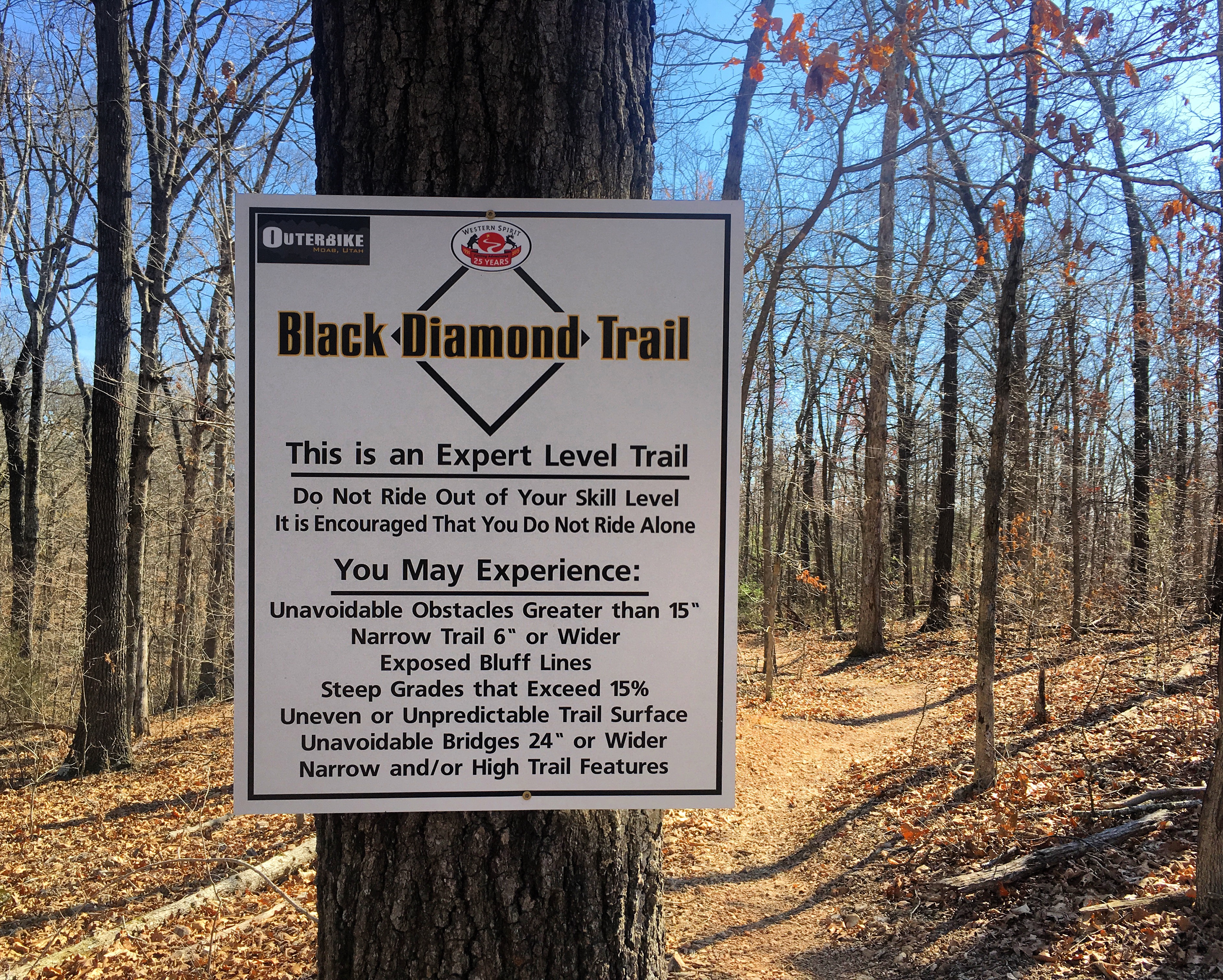
While the XC singletrack had been great up to this point, a little expert-level diversion was just what the doctor ordered! But after reading the sign, I questioned the wisdom of continuing. Exposed Bluff Lines? Unavoidable bridges? Unavoidable obstacles greater than 15″? How “narrow and/or high” were the trail features going to be, exactly? After I personally passed on some big ladder drops the day before, opting to shoot photos of Nathan instead, I felt a bit apprehensive.
“What the heck, we’re here, we might as well ride!” We decided to go for it anyway–Nathan I choosing to ride Ledges very carefully for fear of slashing our tires, and Steven taking the flowier alternative trail.
As we dropped into Ledges, the berms and jumps increased in size, offering a ripper of a flow trail! Eventually we started encountering rocks, so we pedaled easily and cautiously to avoid slashing a tire. Eventually the trees opened up, as we traversed a small rock shelf above a dirt road.

In a few minutes, we arrived at a trail junction that we didn’t expect. But as we checked the map, we realized that this was where the Ledges rejoined the main loop. “Wait, was that it?” we asked ourselves. “Where was the exposure? The obstacles? The bridges? The tire-slashing rocks?” We hadn’t seen any of it. In retrospect, we realized that the small rock ledge was the formidable, intimidating exposure that we had seen warnings of online.
After all the build up and hype from online trail descriptions, locals, and trail signs alike, the Ledges proved to be a massive letdown. Perhaps if we had rolled into it with no expectations we would have been able to enjoy it more for what it was, but after seeing such an intimidating trail sign we were fully prepared for the raddest stretch of singletrack of the entire trip. Instead, we were massively let down.
In fact, this might be the biggest let down from a trail sign I’ve ever experienced in my life.

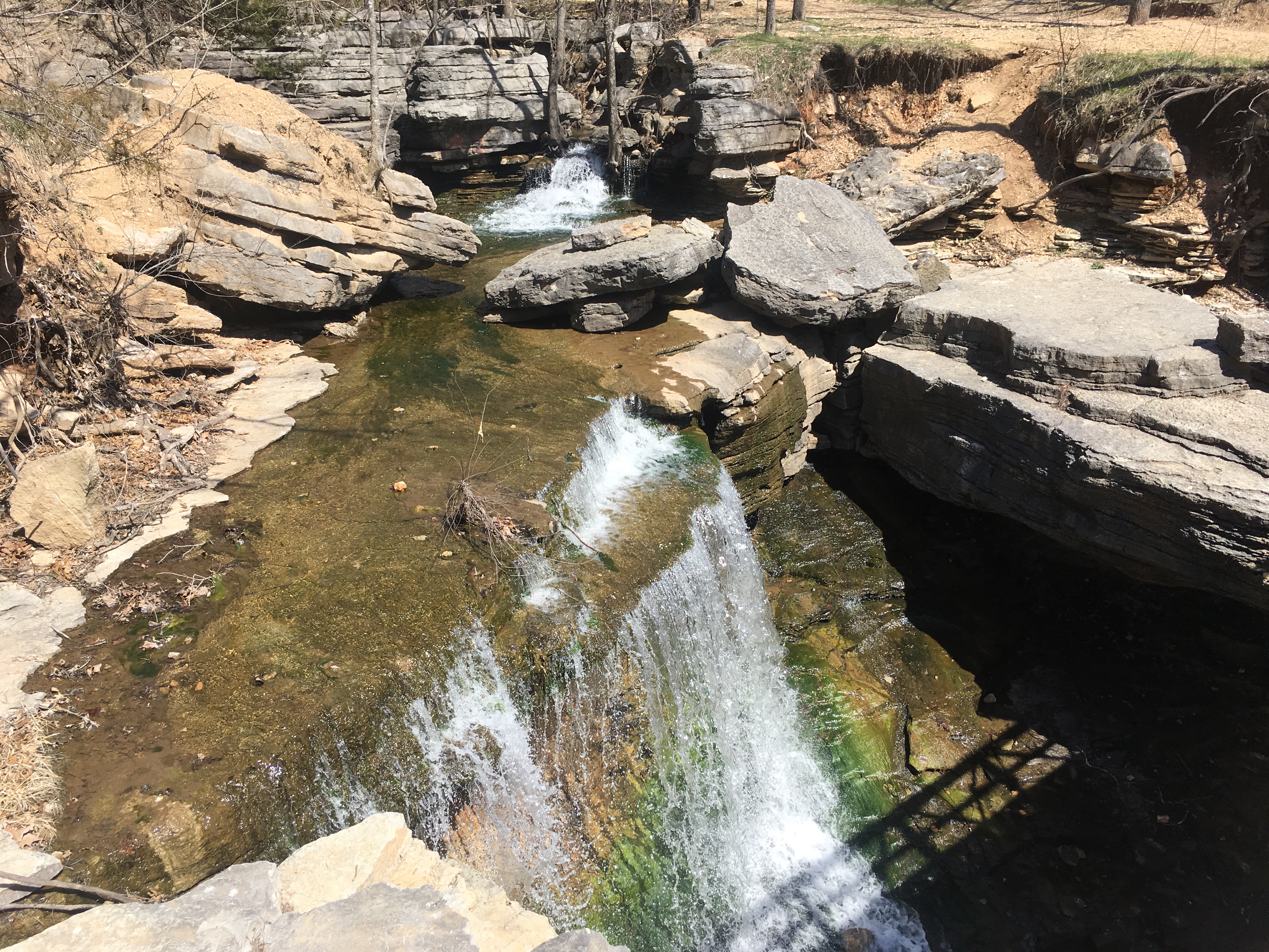
We kept on pedaling, choosing to enjoy what the trail system had to offer instead of being led astray by ill-conceived trail signage. What we found were trails that flowed both downhill and uphill, gorgeous rock cliffs overhanging the singletrack, and cascading waterfalls. What we found was, in short, an incredible mountain bike ride!
Unrealistic expectations can ruin your life: they can ruin your relationships with the people around you, and they can ruin your enjoyment of the fleeting moment that you’re currently experiencing. If you set expectations that are too high or can’t be met, even the most incredible mountain bike ride can seem like a letdown.
Put the Back 40 trail on your to-do list. Just leave your expectations at home and enjoy this trail for what it is–nothing more, nothing less.


2 Comments
Jun 29, 2017
Jun 30, 2017
Upper Buffalo was great through--super tech!