Follow the trail along the Interstate until it starts to climb. After 14 switchbacks, go over the top of the ridge. The trail stays on top of the ridge. At the only fork in the trail, take the left side trail. There should be a sign pointing to the Old Fort Picnic area. Once you reach the picnic ground, go to the main road and take the immediate left turn. Go around a white gate 1/8 of a mile up and follow the paved road until you get back to Royal Gorge Rd. again.
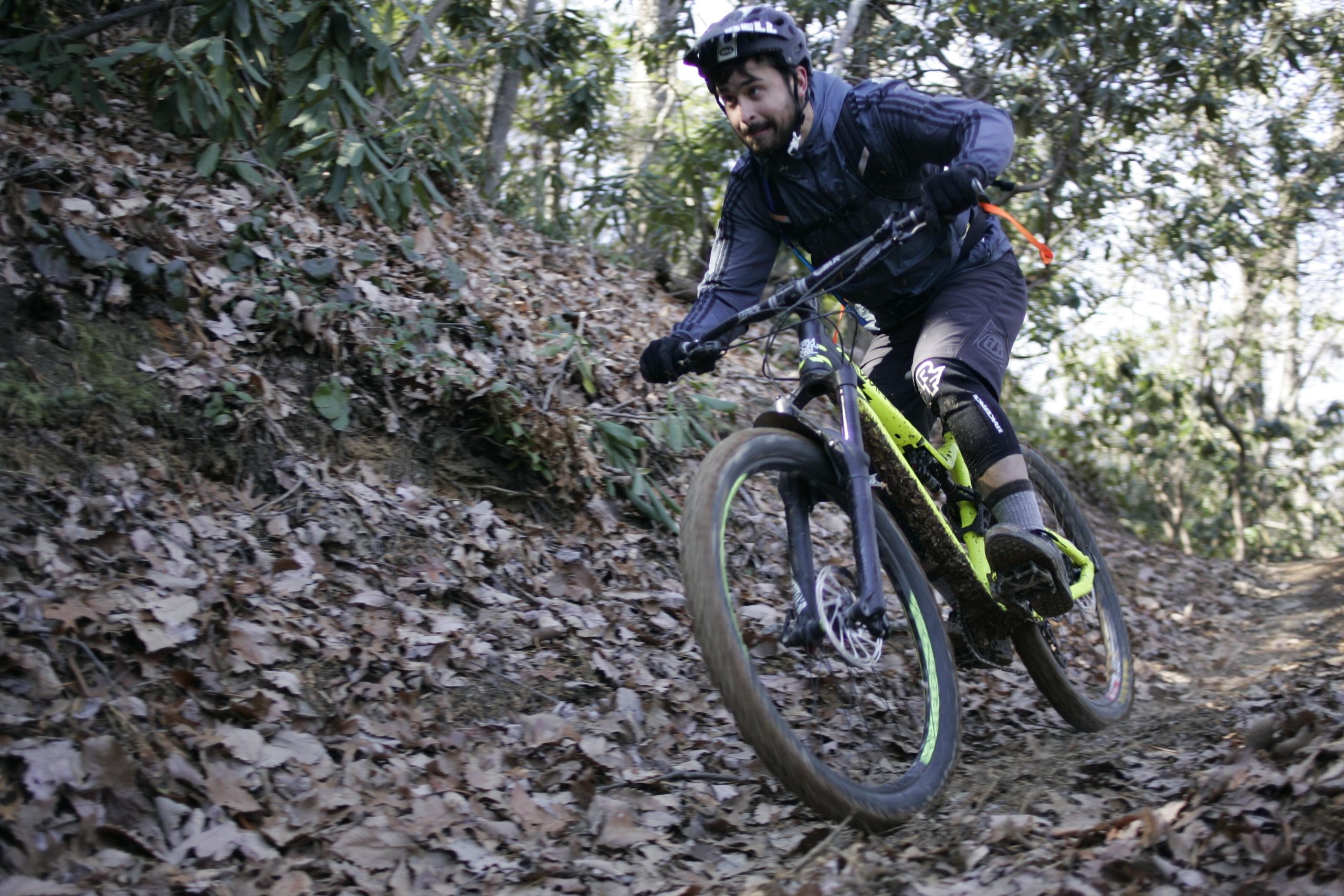
The singletrack trail goes from Ridgecrest to the Old Fort Picnic grounds, and through a beautiful section of the Pisgah National Forest. The elevation change is around 2,200 feet. The climb up the 14 switchbacks to the top of Kitsuma is tough, but the downhill off the eastern slopes of the Blue Ridge range is worth the effort. The first downhill section is very steep and rocky. In wet conditions, I hike-a-bike this section.
Next is a section of ups and downs with flats and then around 4 miles of super singletrack downhill. The trail is narrow and there are some serious drop-offs if you leave the trail.
The ride back up the Blue Ridge is along a gated (no cars), overgrown, paved road with beautiful views of the ridge line you just rode down and the Blue Ridge and South Mountains. It is about 5 miles back up, but it is not steep.


 1
1

Nice bite-sized taste of Pisgah. Climb up is nasty enough to be memorable, but leaves plenty of gas in the tank. Views are spectacular, and descent is smooth, fast and fun (but over too quickly).
One of the big strong points is how accessible the trail is. The trailhead is right off I-40, and you immediately get a sharp climb followed by a ripping downhill within about 30 minutes. Nothing crazy technical, and you don't have to gravel grind an hour into the forest to get to the good stuff.
| ThankFast fun and steep, really easy climb up the greenway trail to the singletrack where the switchbacks are gnarly but rideable, then the fun begins!
| ThankClimb the14 switchbacks& enjoy amazing downhill action. Said & done.
| ThankThis is a great loop. I prefer parking at the bottom (west) end and starting with the long, gradual climb up the paved greenway trail. The grade is consistent and there's no motor traffic, so it's an easy but pleasant way to earn most of your vertical. Once on the singletrack, the first mile is a vicious climb, and there's a couple short climbs thereafter, but the rest of the trail is an absolute scream of a downhill. Not very technical, more roots than rocks, but there's some good line of sight that allows for some real speed, and there's some seriously steep, real dive bomber sections. The view from the top is also nice.
| ThankWhat a great trail! Initial climb is challenging, but not overly tough. Keep your momentum up as you go into the switchbacks. Once at the top, you are treated to a great view of I-40 weaving through the mountain valley below. The trail along the ridgeline is full of kickers and woop-de-do's that are just plain fun. There are a few spots that demand your attention along the ridgeline, else you end of in the laurels. Once down to the bottom, the ride up the paved side road was constant grade and made for a good recovery. I would definitely ride this trail again!
| ThankRode this after riding Star Gap/Heartbreak Ridge. I parked at the bottom at Old Fort Picnic Area and climbed up Old US 70. The climbs at the top of Kitsuma are tough but the descent back down is super fast and fun as hell. This is a must ride if in the area imo.
| ThankNote, the road back to the trail head is closed from the park on the back side of the mountain. You have to take Old Mill Road (I think that is the name). It is a long uphill ride back.
| ThankInitial climb to Kitsuma peak is no joke, especially the first few switchback sections. When you think youve reached the top youre not quite there yet. A couple more climbs and then its a rough rutted downhill for what seems like forever. Its pretty steep and loose in many sections but not particularly technical except for a couple sections near the top. Brakes and hands get a workout from the steep descent but its a great ride. When I got to the the bottom and took a left out of the park i quickly learned that the usual route back to the top is now closed for repair until September and the detour along the Mill road is a couple of miles longer. A 12 mile loop all together.
| ThankHold on tight because this downhill is FAST FAST FAST
| ThankI read the other reviews & I still went. That switchback climb was hard & steep, but really not that bad. Yes I hiked a bunch of it but I've hiked worse. My big problem was the views along the ridge. I almost wiped out a couple times check out the awesome views rather than where I was going. The views are awesome, STOP & take them in if you like. The downhill was great, I need my brakes adjusted though, make sure your brakes are good. Then the final phase that I thought would be the worse than it was the 6 mile ride back to my truck. It's paved and stays pretty much the same slope angle, gets a little boring at times but there are a couple of good views of the mountain & ridge I just rode to keep me company. I'm 45 & just started exercising again in the spring & started mtn biking in May & was able to do the loop in an hour and 45 minutes.
| ThankSweet. I love that the climb at the beginning limits the number of people riding the trail. Lift accessible DH is nice, but I think THIS is what mtn biking should be. Grind your way up, and reap the rewards all the way down! I rode it on a 26" hardtail, so I may have been a little under-equipped, but had a blast nonetheless.
| ThankThe switchbacks going west to east up the mountain are steep and tight. Not super technical though; a few roots and rocks.
There are a couple of false summits on the trail, so don't get too excited when you first start descending. There's a little more climbing to go.
Once the descending begins in earnest, it's a wild ride. You can get going very fast and get in over your head if you aren't careful. There are a couple of tighter turns that you can easily overshoot.
There are a couple of root sections and some straight down the mountain sections. Be a little conservative on the descent if it's your first time down, and make sure your brake pads are in good shape!
| ThankIf you love long downhill this will be perfect for you Padyakeros! Just pure adrenaline rush once you're @ the top of Kitsuma Peak. Start @ the trailhead hitting 14 switchback of uphill climb to the Peak of Kitsuma. Make sure your brakes are working! Then 4-5 miles of DH descending to the bottom with some pretty big jumps before hitting the picnic area at the bottom of Old Fort Pisgah National Forest.
| ThankNow ready to ascend on a pave trail going back to your car. Five miles of 6% grade of beauty and madness ;-)
Enjoy the ride and live another day to RIDE!
The initial climb is challenging, especially for the first timer here. But my goodness that downhill is amazing. Wish I could get my DH bike up there to hit all the drops at full speed, my XC handled it nicely though. I would like to shed some light onto how to get back to the trail head once you complete the downhill:
Once you exit the trail into the picnic area you'll want to head to the right out of the picnic area and onto the road. From here you will take your first left and go by two homes with the creek running beside you on your left. Take that road all the way till you come to the gated area and keep going. It's a challenging climb if you're exhausted from the trail, just lock your suspension, raise your seat, and climb for about 35-50 minutes. There's some great views from the road. When you exit the road you'll be on an open road with cars so be careful. Take that road all the way down till you come to the 4 way cross. take the left and you're on the road back to the trailhead. It's worth it! You may not think so when you're on the climb back but when you get to your car you know it.
| ThankLove this trail!! Beautiful views at the top:)
| ThankGreat trail with a few tough climbs. The downhill section is fast and finished before u know it. I wasn't a fan of the gated highway trip back because it seemed to go on forever. I will do it again but not when it is 89 degrees and high humidity. Must ride for any advanced to intermediate rider.
| ThankYes, nice climb if you like climbs do it twice. Fast downhill.
| ThankPeople aren't lying when they say the climb at the beginning is rough. It a real leg burner work your way up it, take breaks when necessary and you'll be alright because the ride down is completely worth it. Flying along the edge of the ridge at top speed with plenty of obstacles along the way to keep you grabbing the handle bars with all your strength!!! The ride on the road back isn't difficult but a little boring after the roller coaster you just went through. Drove from Charlotte in 2 hrs and it was completely worth it. This trail had me stop a couple times to take in the scenery and smile at how much fun flying down the ridge line was.
| ThankThe first climb up the switchbacks is a challenge and a good warm up.. The singletrack is good but not great there is alot of erosion and spots for a high risk crash, more of a challenge than it is fun for my taste.. The climb out on the old highway is a easy climb with some great views.
| ThankExcellent technical trail with a difficult climb to start the ride. All 14 switch backs are rideable. Trail has been recently modified as you approach the top of the switchback climb. Instead of going to the summit where there is a primitive campsite and descending down the steep back side, a new, short trail has been cut to the right to bypass the original steep descent. This is right before the final push to the summit. The new trail is well-marked with a brown trail sign. This is a great ride but in my opinion, more difficult than Bent Creek and Dupont. The trail is in good condition as a decent amount of work was done to it in the past year. Numerous undulations. It is worth the effort as the trail is very exciting and challenging. The climb back up on the newly paved Point Lookout Greenway Trail is relaxing with good views and no car traffic, since it is gated. It is a long, continuous push but nothing overly difficult. * Review edited 1/2/2012
| Thank