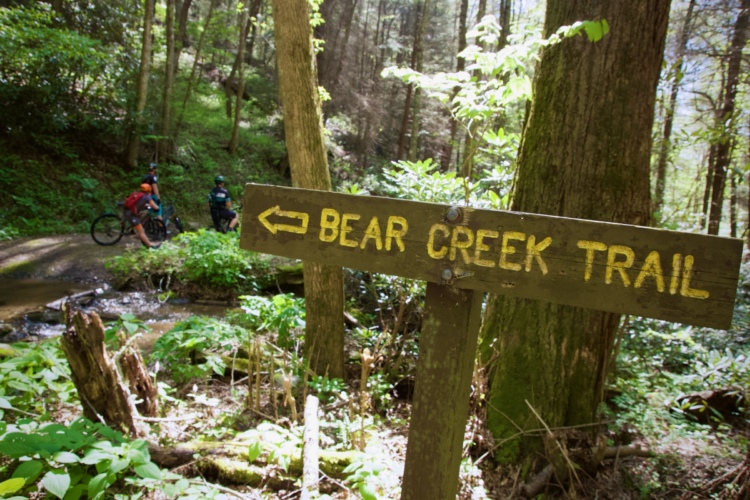
The Bull / Jake Mountain system is full of single track and there is plenty of fast downhill throughout. The scenery is great, too. Mountain laurel makes tunnels over parts of the trail and there are creek crossings and waterfalls. The trails are basically split 30% primative road, 30% doubletrack, 40% singletrack. This area can be confusing so be sure to bring a map! Plenty of forest road intersections and bail out points.
Total climb for the entire network is about 3,000 feet, though there are several loops you can make with as little as a few hundred feet of climbing each.
Update 7/11/13 by mtbgreg1:
Some people have mixed feelings about the Bull/Jake Mountain trail system, one thing is certain: this trail system is one of the premiere mountain bike destinations in North Georgia. Sure, there are better trails in North Georgia, but there are definitely worse trails, too. If you're looking for riding in the Dahlonega/Dawsonville/Helen area, this is undoubtedly the place to go.
The trails have changed significantly in the past couple of years, and they will continue to change. The US Forest Service has been rerouting many of the trails that were built unsustainably. Again, these reroutes aren't without their detractors (as the new trails are very buff and smooth), but in general the riding in the Bull Mountain area is now the best it has ever been. And with new trails proposed in the coming years, the riding here stands to get even better.
Right now, the trail system can be split into two different halves. The Jake Mountain side of the system (which includes trails such as Jake Mountain, Black Branch, No Tell, Turner Creek and Moss Creek) is, on average, flatter and smoother than the Bull Mountain side of the trail system. If you're not from the mountains, don't let that fool you, though. Despite being flatter than the Bull Mountain side, nothing out here qualifies as "flat": you can still easily climb a couple thousand feet in less than 20 miles.
On the Bull Mountain side of the trail system, the trails on average are steeper, with longer climbs, and are rougher and more technical. The Bull Mountain, Whoops, and Lance Creek trails comprise this half of the system, and the Jake-to-Bull connector and Jones Creek Ridge trails function as the links between the two halves. Consequently, Jones Creek Ridge and Jake-to-Bull have more climbing than the Jake side, but are smoother than the Bull side.
Without a doubt, the full Bull Mountain loop is the main challenge, with long, steep climbs, fast descents, and some decent rocks to keep things interesting. The Bare Hare trail at the top of the Bull Mountain loop also reaches the highest elevation of any of the mountain bike-legal singletrack trails in the area, providing some pretty cool mountain riding.
When you come up here, be warned: this is one of the most popular equestrian trail systems in North Georgia, so be prepared to yield the trail to horses. But don't let that deter you from experiencing the awesome mountain biking!
For a loop route with the most singletrack riding and the least gravel road, and absolutely NO backtracking, be sure to check out the map for the Dirty Thirty recommended route.


 15
15

I don't see what the big deal is. The climbs suck and the downhills are short, straight, and buffed out It's a solid intermediate trail system. The climbs suck (did I mention that yet) and the downhills are not great on the Bull side. I'd ride the Jake side again, but won't be going to the Bull side. I didn't get a good return on investment for the amount of climbing that is required.
| ThankI love this trail. I got lost on my first try, so make sure you take a map with you and study the system ahead of time. It can get confusing in certain parts. The 10 mile orange loop is great with its climbs and descents , its pastures and mountain range views.. and creek crossing. Make sure you get your caveman on and submerge in the larger creek.
| ThankBull/Jake Mtn fast becoming my favorite place to ride in North Georgia. Apart from great variety of trails, with a good mix of uphill & downhill, the fact that you can create loops ranging from 10miles, 15miles, 20 miles & 30miles or even switch it up mid ride if you are running low on energy, makes this area unique. Most destinations are set loops or out & back.
Cell phone reception is not good, so ride in a group or if alone, let someone know your route & estimated arrival time. I also carry basic tools & spare parts, since you can be as far as 15 miles away from your car......no fun in hiking your bike out !
| ThankDownloaded the gps file & printed a map. Easy to take wrong turns without it. The trail was sweet. Anti clockwise is certainly more fun. Guessing 65% down 35% uphill when done in this direction. Parked in Bull Mtn carpark as trail ends closer than Jake Mtn carpark, but either carpark is ok as the trail passes behind Jake carpark. Highly recommend this 30 mile loop
| ThankFun XC trail and the best, most fun way to quickly connect from the Jake to Bull side or vice versa. Also a good connector to link up numerous loop options. Equally fun, fast, flowy in either direction.
| ThankGreat trail, it was barely muddy after heavy rains last night. Will do again.
| ThankAccess to the Bull Mtn parking lot now open to passenger vehicles.
| ThankWas able to get back out today with some equipment and clear the access to Bull Mtn parking lot for passenger vehicles.
| ThankThe Parking lot access is currently blocked for passenger vehicles. OK for 4x4. I hope to get out there next Monday the 1st of Jan with a chain saw. Most others roads, 77A, 28 & the 9 mile loop at CFM are clear.
| ThankAs of today, October 14th all trees on Jake Mountain are removed and cleared out of the way. Other than the normal horse crap from the horses the trail is in magnificent shape. Jones Creek is up quite a bit I suppose from all the rain falls we've had lately.
| ThankRide Jake Mtn on October 1 and conditions were dry. Unfortunately there are several large scarlet oak trees down across the trail, due to hurricane. USFS and volunteers are doing a great job of clearing fallen debris and smaller trees, kudos to them!
| ThankFun and flowie, but poorly marked rode it last week and got ourselves good and lost. Ended up riding a good portion of Bull Mtn. as well. Had a map, but got caught in rain and once soaked was worthless. Good uphill workout with only 1 real steep section that I saw. Good chance to enjoy scenery on the parts that are fire road too.
| ThankFun trail network with lots of miles and elevation. Tried to do the IMBA loop but made a wrong turn, wound up doing about 28 miles and about 4000 feet of climbing. Jake side is mostly smooth and flowy. Bull side has some great technical, fast descents , but is rugged as hell and the climbs are tough. Take a good map and the signs are good enough, though a few are easy to miss.
| ThankSuch a fun place to ride! There are long climbs/descents (esp on Bull), fun flowy sections, and enough to ride to keep you out there for hours. The local SORBA volunteers have done an absolutely amazing job keeping the trails in top shape. As the other reviews mention, its best to have a map and watch out for horses. Most of the time you can see the horses and have time to move off the trail, but be aware they are out there. If you park on the Jake side, i think it's best to take the first right (maybe 50 yards) and start out with a fun downhill. It drops out with a creek crossing where your gonna get wet...no way around it, so it might not be the best option in colder weather. The bull side is a lot of climbing rewarded by a looooong descent. Killer views either way you go. Definitely my favorite place to ride in GA.
| ThankI suppose this trail belongs somehow to a SORBA somewhere as part of the National Forest so keeping that in mind. This trail really only needs much better signage. It makes it difficult to ride and stop every 1-2 miles just to make sure you haven't made a wrong turn. IMO, there's no better trails that have the awesome long flows as this trail. Some seem they wil never end which makes it that much funner. It's not without its challenging climbs but the descents make it all worthwhile. I do recommend if you're gonna ride on a weekend you better get there early as the parking is quite small and gets packed quick. Bring plenty of water and a snack as you're gonna need it!
| ThankI think I am in love with this system. I felt like I was lost in the wilderness. It was so quiet and pretty up there. Can't wait to go back. I need to remember to bring a towel for the creek crossings. ;)
| ThankIf going north to south, it's a moderately tough climb. Nothing like the old Baby Heads trail it replaced. The forest has largely grown back since they built the trail, so it doesn't feel like a dirt sidewalk anymore. The descent from the top to the dam is a fun one!
| Thankexcellent trails. far enough away from the city that it gave a remote, secluded vibe but wasn't actually too far of a drive. trails were pretty fast and flowy, nothing crazy technical, great all around trail system
| ThankIf I could give this review a higher rating than 5, I would. This trail is amazingly fun and it makes you glad that you ride mountain bikes instantly. You gotta pay the piper to enjoy some of the awesome descents and flowy trails so don't get me wrong. Some climbs will challenge you beyond belief but, there's where any rider learns and grows. The scenery is second to none, the variety of trails constantly changes to keep you alert and excitement level peaking. The trail head is very easy to find thanks to an earlier review from Greg. Oh, I'm gonna be back here many, many times after today. Hands down the best trail Ive ridden.
| ThankFun, fun ride. Watch for horses, but expect the riders to be courteous. Signage is pretty good. You Ann pick up a map at Cartecay Bike Shop in Ellijay.
| Thank