

Imagine yourself pedaling over rock and tundra surrounded by a dense fog. Every breath is labored, and you feel lighter, as though your sense of gravity is fading. In the horizon lies an endless array of snow-capped peaks. After hours of turning gears, stand atop the fold with your all-terrain cycle, exhausted and yet euphoric. Relying on both brains and brawn, you have outwitted the mountain’s truculent vertex.
The Inspiration
Being a country boy from the bean and corn fields of Minnesota, riding the Himalayan peaks of America sounded cool; no wait–radically epic. So when my family moved to the semi-arid, too damn hot city of Aurora, CO eleven years ago, I often envisioned myself pedaling atop the dry to snowy ridges of the Continental Divide.
It took a few years to get truly settled into city life and to take time away from my young family. We eventually bought a nice pad located closer to the foothills and in 2005 the dream started to become reality. Getting away from the routine drudgery of work, a trail buddy and I took off to Fairplay located on a plateau of the Rocky Mountains.
Riding a section of the Great Divide Mountain Bike Route (GDMBR) and immersing myself in the majestic beauty and barren tranquility surrounding us, I wondered why I couldn’t ride more sheer points. Five to six years and several excursions and reroutes later, I had pedaled or hike-a-biked a new, more heaven-bound trail route. Flat tires, minor breakdowns, equipment upgrades, monsoons, sleet, snow and unplanned campouts in isolated country shaped the experience.
It’s in the true definition of our hobby: the torturous climb followed by the adreneline-pumping descent, that this ultimate riding experience was found. RAD (Ride Along the Divide) as it would be called came to encompass what “mountain” biking is all about. A roughly 1,500 mile route zigzagging through the Rocky Mountains from Encampment, WY to Chama, NM. This would be one of the longest high elevation networks of multi-track trail in the US, if not the whole American hemisphere. RAD necessarily mixes in 4wd, dirt, and paved roads to keep a constant line going south over, next to, and atop the Continental Divide. But, there is plenty of great tread for the “narrow” minded trail rider too.
The Route

The green line shows the main RAD route; red lines indicate alternate routes.
With cycling elevations that transcends the usual and utilizing some of the greatest singletrack in the lower 48, Colorado is my designated playground. Outdoor recreation reigns supreme 365 days a year here; when the snow melts off the ski slopes it’s time to lube the chain, work all the kinks out of the all-terrain cycle, and head back to the high country.

Does anyone start or end a ride right at a border crossing? I sure didn’t think so. I started and ended RAD by pedaling from and to the towns nearest the perimeter, even if the way on the other side of the border was wide and pretty mellow.
The starting line is Encampment, WY, a quiet village located in the Medicine Bow National Forest. Leaving the paved road from Battle Pass, the route approaches the bastions of ancient volcanic rock, decorating the horizon. From the forest road, the first spaghetti-lined tread fires off east just a few short miles below the Wyoming border, then follows the National Scenic Continental Divide Trail (NSCDT) on an easy to tumultuous route on or near the top of the world.

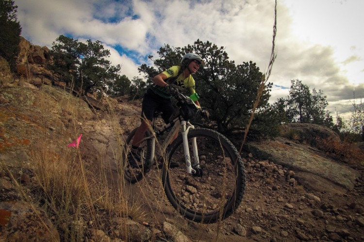
In all, the route touches 80 mountain passes or high-points, utilizing various trails of minimal to moderate usage such as: Arapahoe Ridge, Sourdough, Herman Gulch, Timberline and Monarch Crest to name a few. Waffling from wide to narrow paths, the rider is like a cat pouncing on a ball of yarn in an attempt to rip a string of looping and snarled lines. With that being said, it’s often necessary to fight the trash heap of the rock-laden jeep roads on a less sinuous track to reach these hidden gems. In laying out the route I had to avoid the wilderness areas and private land where the best singletrack is often found.
During one scouting expedition in the Sawatch Range of Gunnison before I had replaced my then current ride, a 7-speed Trek, a late afternoon hurricane of a thunderstorm forced me to to get a lower elevation quickly.
It was day 4 of a 370-mile ride from Alma in the Mosquito Range to the western San Juans at Telluride, CO. Riding south of Marshall Pass into the Cochetopa Hills on the Colorado Trail, the clouds looked inconspicuous. Then after a couple hours the sky blackened suddenly, and a monsoon commensed on a track already worn by motor bikes. I tried to shortcut on a trail to the nearest town but an often indistinguishable path and slippery conditions slowed my progress so significantly that I turned back to the previous trail. A layover at 11,000 feet was inevitable. The waterproof state of my pack and jacket certainly left more to be desired.
As the rain subsided, crimson western skies put the last chapter on the day. I hunkered down on a slope in a small clearing and waited for the sun to return. The ground was too wet for a fire, but fortunately I still had plenty of H2O and granola and protein bars to replenish my weather-beaten body. Sleep was sporadic to non-existant, until a ray of morning light brought me to my feet. My cell phone had no reception, so I spun back to the trailhead at Marshall Pass, rushed down to the small mountain town of Sargents, and called my wife who had already alerted local authorities. The plane flying overhead as I rode back that morning made me wonder if a search party had been mobilized.

The greatest of overlooks with some ridable track are found on the cliffhangers of the Front Range south of Jones Pass and on the crown of 14ers in the Mosquito Mountains. Here talus slopes and precarious ridges of loose shale mandate a more cautious traverse. Let’s make one thing absolutely clear: much of the surface you’ll roll over here is often just the opposite of cultivated, smooth singletrack. The corners are not typically rounded for effective switchbacks, and hike-a-bike may be more frequent depending on the rider’s experience, but none of that will stop the intensely committed, half-crazed cyclist.
RAD’s offroad character ends near the border of New Mexico, but to complete the journey RAD ends at Chama, NM for a more civilized end point. Chama is the home of the Scenic Cumbres/Toltec Railroad station and offers a chance to grab a burger and beer to celebrate the end of the ride.
Mission Accomplished
Maybe a year later, someone (I don’t remember who for sure anymore) suggested I write a book about the route and my experience on the trail. As a writer by trade, I liked the idea of putting it on paper not as a personal memoir, but rather as a guide to other mountain cycling fanatics. The scenery I encountered while shredding the trail are astounding, and more amazing than could be put into words. In the end, it’s something you simply just have to experience yourself!
Click here to check out the complete book!


10 Comments
Jan 10, 2013
I'd like to see a gpx file for this route if available. Sounds way more interesting then anything similar I came across yet.
Jan 11, 2013
Jan 11, 2013
Jan 11, 2013
Jan 11, 2013
Jan 11, 2013
Jan 11, 2013
Jan 11, 2013
Jan 14, 2013
Jan 10, 2013
Now who will be the first to ride RAD end to end?