
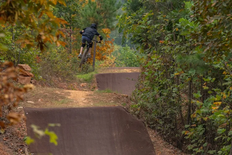
Yesterday was day 13 of my 29 Day / 29 Trail challenge and I managed to bag three – count ’em – three mountain bike trails, including one that wasn’t even listed on singletracks yet! Things are still drying out here in the Atlanta area and after driving nearly an hour west of the city to Paulding County yesterday, there was a foggy mist in the air which had me worried. Paulding SORBA does a great job maintaining their trails and like most clubs they’re serious about keeping riders off wet trails. Based on the weather overhead I was sure I’d find the trails soaked, though it hadn’t rained in a good 36 hours so I was cautiously optimistic.
Sara Babb Park

The Paulding SORBA website describes the 1.5 mile loop at Sara Babb Park a “Gateway Trail” and I assume they’re referring to the IMBA designation for trails that are located close to where folks live (often in urban areas). I couldn’t find any mention of the park on IMBA’s list of Gateway projects but apparently the club has already put 1,000 volunteer hours into creating the first loop which is a big deal.
The trailhead was well marked with an official sign but beyond the sign I wasn’t really sure where to start. I rode across the field directly behind the sign past the tennis courts, around the volleyball pit, and beyond the baseball field until finally I saw it – singletrack! While the field itself was pretty wet, the trails were actually in great shape thanks to fresh leaf cover (does anyone ever ride here?).

I followed the yellow arrows around the loop (even days) and almost lost the trail a couple times. It seems like this system may have started out unofficially and now the volunteers are working to reign in the sprawl. There were several small trees down across the trail and at first I thought it was due to the recent snow but after a while I got the feeling the trees had been placed intentionally. I cleared the trail the best I could, rode a second time around the loop to make sure I didn’t miss anything, and jumped in the car for trail #2.
Mt. Tabor Park

This summer I rode a short time trial at Mt. Tabor and had a blast so I was stoked to get back on the trail. Yes, the trail is short (the main loop is just over 3 miles) but for some reason I really like this place. The Rocks of Doom section really flows well and the hardpack with rocks through the pine trees somehow reminds me of Colorado.

Yesterday I got a chance to ride the newest section – the Booger Trail – and I was amazed at how much mileage had been added since the summer. There’s a surprising amount of climbing here (about 100 ft/mile according to my GPS) and just enough rocks and roots to keep things interesting. The trail was a little sticky in places so I “tiptoed” through some sections to avoid damaging the trail. All told I clocked about 6 miles in 45 minutes and I was pretty spent. But trail #3 was calling my name…

The Silver Comet Trail is a paved rail trail that starts just west of Atlanta and runs clear to Alabama and beyond. Roadies and joggers love the trail for the scenery and the lack of traffic but mountain bikers quickly find themselves getting bored with the flat pavement. Fortunately, Paulding SORBA has us covered.

blue: SC Side Trail elevation; pink: paved SC trail elevation
Like most rail trails, the trail corridor itself is fairly wide and is buffered on either side with woods and fields. At some point, someone got the brilliant idea to construct an off-road path that parallels the paved one. Starting at the trailhead off Seaboard Ave. in Hiram, the side trails are well marked with blue blazes and white arrows as the trail leaves and rejoins the Silver Comet Trail. The mountain bike trail makes excellent use of the surrounding topography and as you can see from the chart above there’s a good bit of elevation gain/loss compared to the main path (pink).

I had ridden parts of the side trails before but today I decided to explore a different section heading west toward Alabama. For more than 3 miles the side trails stay off the paved path and alternated between wide, doubletrack to rocky, tight singletrack. As dusk approached I wished I could have continued on but I decided to hop back on the paved path when it seemed like the side trail disappeared for an extended period.
Augusta Area Trails
This weekend I’m heading to Augusta to notch at least 3 more trails which will bring me to 9 trails in 16 days. More precipitation is in the forecast for early next week so I need to get in as much riding as I can over the next 3 days if I’m going to meet my goal. No one ever said riding 29 trails in 29 days would be easy – I just wish it wasn’t the weather that was determining my pace!


2 Comments
Jan 21, 2011
Jan 21, 2011