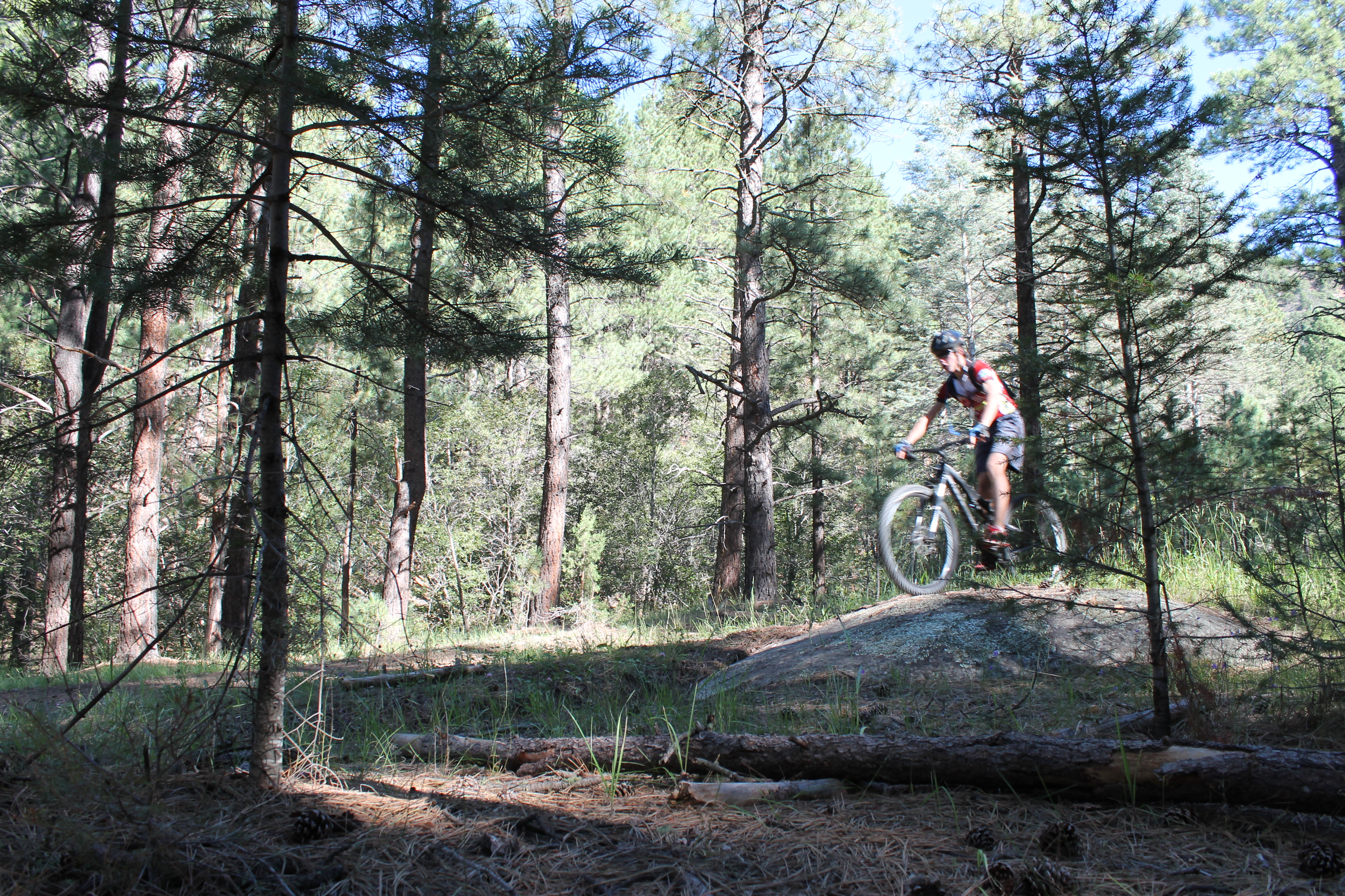
This is a fun downhill that can be ridden as an out-and-back or as a shuttle. From the Norski trailhead to the bottom is 9.8 miles, making for a quick downhill run or a good cardio workout if you do it as an out-and-back (7,200í at the bottom to 10,307í at the top). The actual trail continues on for miles beyond Norski (bikers can only venture as far as the wilderness boundary), but, from a bikerís perspective, Norski is a good place to start. The top section is singletrack that winds its way down thru single and double-track sections. Ruts, roots and loose rock may be encountered ñ I have to say I was a bit surprised about the poor maintenance at the top of this popular trail ñ but nothing bad enough to seriously detract from the ride. Other than a few rock outcrops and rutted corners there are no significant technical challenges, so this trail can be ridden by anyone comfortable with singletrack, but may not offer enough challenge for some. The last couple miles of the trail crisscross Tesuque Creek many times, so be prepared to get your feet wet. If you want to shuttle, but donít like the long drive from the bottom, you can make the Chamisa Trailhead on Hyde Park Road your destination. Ride down the trail just over five miles to the Chamisa Trail (183), and then climb about two miles out of the canyon to the Chamisa Trailhead on Hyde Road. There are plenty of other variants as well. For additional grist I recommend getting the excellent Santa Fe map of the area made by Sky Terrain (www.skyterrain.com).
 | Borrego / Winsor Descent | 7 mi | |
| Winsor, Fr 102 Cutoff | 9 mi |


 5
5
One final thought. I can't believe this trail is rated #217 here on ST. It's gotta be the most underrated trail on the website. It's up there with the Mongolia trails I used to ride -- all waaaaay underrated. Given the downhill profile, the speed, the gnar, the flow, the fun, the beautiful pristine forest, backcountry feel (have seen bear, grouse, coyotes), river crossings, ease of access, lack of riders being near to town, and the quality condition of the trail (can't remember a single rut and overall good grip), imo, this is easily a top 50 trail, probably a top 20. Santa Fe and Albuquerque riders, you have a real backyard gem!!!
| ThankAfter riding Winsor the first time a year ago with my youngest son, he was determined that we come back and shuttle it multiple times in one day. We finally got to do that this past Saturday. We had several other riders with us. So after a late breakfast in Santa Fe, we took turns shuttling one another. Most of us rode the trail three times for a total of 28 miles and 10,000'+ of downhill bliss. What an amazing trail!!! It just keeps giving and giving. If you ride the trail straight through with no stopping, a decently good rider can descend it in about 30 minutes or so, 40 tops. Also, I will update my estimate below of the amount of ascending as you ride the trail downhill. It's probably more like 30' of ascending (ha!) - mostly just a handful of very short ups coming out of drainages. That's still essentially zero over 9+ miles, and a true downhill shuttle.
| ThankAs advertised - a nine-mile downhill romp. Absolutely loved it. Approximately 3350' of descending and only 10' of climbing ... literally! How can you not love that! Beautiful mixed conifer forest most of the way ending in the Pinon-Juniper. Parking at the bottom can be a little tricky. There are two very small parking areas at the bottom on CR 72A (Big Tesuque Canyon Road). Try to park a car in one of those before looking for parking further away. The shuttle is a little long, but who cares. It's easy, BEAUTIFUL and the riding is totally worth it.
| ThankI go 4 stars with the understanding I save 5 stars for truly epic (example Sedona or Copper Harbor). Very cool experience. Shuttle the Blue Bus up - I can't imagine trekking this trail uphill. This ain't no smooth flow going down, fair amount of rocks but you can still build a rhythm. You'll be surprised how much of a workout 10 miles downhill can be.
| ThankWe dropped in on the trail from Lower Tesuque Creek. Judging on what we rode, this trail is amazing. The flow of that trail is unparalleled as it wanders down into the desert. Just make sure to have some wet chain lube, because there are probably about a dozen creek crossings at the bottom.
| ThankThis trail is a nice reprieve from all the climbing NM has to offer. 9 miles straight down. Stay to the right at every intersection and you cant get lost. Would be nice if one of the shops offered a shuttle on this- otherwise someone has to drive to the bottom and wait. I saw coyotes halfway down and got nervous around the water looking for bears. Came out smiling and in one piece. This is a must do if you like descending. We should have a video up on youtube of this trail innits entirety in a few day. VECON Sports.
| ThankI got to ride this trail as a shuttle on a recent trip to Santa Fe. Three times down as I couldn't get enough! It starts with beautiful high elevation pine and aspen forest and ends with rocky high desert after following a perfect drop in elevation. A must do for sure!
| ThankTechnical, climbing, multiple stream crossings. Very fun trail. Will ride again when back in the area.
| ThankI have no reservations about giving this wickedly amusing downhill romp a full five stars. If you start from the ski area, you get an extra mile plus of sweet singletrack, but you will have some climbing along the way, making it more than a pure downhill run. From Norski, the upper third is tight and technical, the middle third is open and fast, and the lower third is super twisty and full of creek crossings, but it's all superb! Easily the best trail in the Santa Fe area.
| ThankGreat trail if ridden down as I did. Could be a serious workout climbing for those not used to altitude. Nothing unrideable there. A variety of loose rocks, roots, many creek crossing etc. looks like I've found my new favorite trail in Santa Fe area.
| ThankWooo, this trail was a blast! Downhill with pedaling to maintain speed. Not too many rocks, mostly just fast! I was hanging waaay off the back of my XC bike the whole time.
Been dying to do it again, but it's a long shuttle.
| ThankFun trail.
| ThankSurprising amount of climbing interspersed with the downhills that keep you working-- with the altitude some of the climbs were lung burners.
Trail was in good shape for the most part, only a few tricky spots. Could use additional signage for out of town rider's confidence in navigating.
Awesome downhill, rideable on a hard tail (which I did) but probably would be more fun on a full suspension bike. There was a kid out there on a downhill bike and he managed to snap his seat off right in front of me... This trail was a lot of fun and connects up with other trails like Chamisa and (with a mile or so on a road) Aspen Vista.
| ThankGreat overall trail. Great views and well as fun stream crossings. For those not used to the altitude, downhill is great, uphill is challenging
| Thank