Once on the trail proper, the first 2 miles are a more-or-less relentless, steep uphill grind. The third mile levels out somewhat (although it's still uphill) as it follows a ridge toward an intersection with paved road 2102. Here the trail continues to the right another .4 miles through several tight switchbacks to the pinnacle of Larison Rock with its fun, but unimpressive views of the surrounding hills.
The ride back down scarcely requires any pedaling at all. The trail is mostly free of roots and rocks, and has very few natural obstructions to speed so you're free to go as fast as you can stomach.
Given the steepness of this trail, all but the very fittest will be pushing their bikes up at least part of it, and all but the craziest will be riding their brakes on the way back down.
Many ride this trail as a one-way shuttle ride from town, and many others opt to follow gravel road 5852 about a mile to the left to where it meets with road 21. Turn right here and follow this paved road a short distance to the beginning of road 2102 on the right. Follow 2102 about 4.5 miles to the upper Larison Rock trail head.


 9
9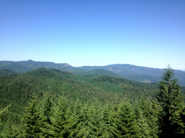

Fun, fun, fun! Very similar in terms of length and feel to others in the area like Flat Creek and Aubrey. We shuttled this so I can't comment on climbing or looping. Fast, flowy, and some serious exposure on blind corners.
| ThankWe pedaled out from camp at La Duke road just past where the Larison Rock trail ends. We didn't realize the climb up was pavement, this made things easy and getting to the trailhead was a snappy climb. The single track descent is sick and is only topped by the Alpine Trail. Very scenic, shaddy, and just super dang fun to ride.
Don't forget your mosquito repellant.
| ThankI rode this trail by looping it and pedaling up the pavement, and the ride up to the top was punishing and boring. I really wish I had gotten a shuttle.
| ThankThe .4 mile grunt to the very top of the rock is well-worth the effort for the amazing views!
Once you turn downhill, the descent is a real brake-burner, with fast, steep singletrack and some pretty serious exposure on the steep mountain sides. All in all, a great ride!
If you're riding this trail as an out-and-back (an up-and-down, really) you've got your work cut out for you. It's a non-stop grind going up. Of course, there's a big payoff for all that work--the decent. If you are looking for a long stretch of fast, smooth downhill singletrack, this is the place to come.
| ThankIf that's not enough, ride over to the flat creek TH for another couple of miles of up-and-down.
Still not enough? Zip up the North Salmon Creek Trail and back down to round out your day. That's what I did last Saturday, and it was awesome!
I'm rating this as 'very difficult' due to the steepness. It's technically easy to moderate.