Heil Valley Ranch trail photo
See all photos (116)
×
User
Today
 
  |   Rate it:

Tags:
Level: Intermediate
Length: 14 mi (22.5 km)
Surface: Singletrack
Configuration: Lariat
Elevation: +2,736/ -940 ft
Total: 423 riders
 

Mountain Biking Heil Valley Ranch

****   Add a review
#13 of 1,366 mountain bike trails in Colorado
#69 in the world

There are currently 13.5 miles of bike-legal trails at Heil Valley ranch, but in order to ride all of them at once you’d have to do at least 23-24 miles of pedaling. The trail system is basically laid out with a figure 8 around the top of the mountain/ridge, and an out-and-back trail running up to it from the north and one from the south. The trailhead location given here, and one of the most popular rides, is to ride from the southern trailhead, up the 2.5-mile trail, around some of the trails on top, and back down. The out-and-back trail coming in from the north is 5.5 miles one-way, so riding from the northern trailhead would make for a longer ride… and riding absolutely everything would make for a grueling experience with tons of climbing.

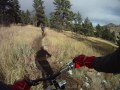
But all of that climbing is worth it, though! The trails here sport that characteristic Front Range rockiness, with plenty of chunk to pedal through on the climb up and around the upper trails. However, there are a few buff sections of trail thrown in at random, and none of the rocks are seriously big. It is all very easy to pedal through, and by Front Range standards is probably only intermediate in difficulty.

Once at the top, be sure to take in the amazing views of the Front Range! Then get ready to descend. The descent back down is what it’s all about, and despite all of the rocks these trails sport some serious flow! All of the undulations, grade reversals, and swooping turns are just perfect, allowing you to carry some serious speed. But since both of the trails climbing to the top are ridden out-and-back, be sure to watch for oncoming traffic and to always ride in control. This trail is very popular, so keep your eyes peeled and don’t get too crazy… but have fun, because the bomb back down is awesome!

First added by alvin.santoy on Apr 12, 2005. Last updated May 10, 2020. → add an update
Before you go
  • Drinking water: unknown
  • Lift service: unknown
  • Night riding: unknown
  • Pump track: unknown
  • Restrooms: unknown
  • Fat bike grooming: unknown
  • E-bikes allowed: unknown
  • Fee required: unknown
This trail information is user-generated. Help improve this information by suggesting a correction.
Getting there
From Boulder, go North on Highway 36 to Lefthand Canyon Road, turn left here. Go about .5 mile to Geer Canyon Road, turn right here. Go about 1 mile to parking lot.
System trails (4)
Featured in


Heil Valley Ranch Trail map

Add to or improve this map // Share this map on your website

Local Info

Trail checkins

Matt Miller (on Nov 26, 2022)
What's this?

Upcoming Events

None.
Add one

Trail conditions

Dry (on Aug 8, 2019)
login to update

Camping & Lodging

Coming soon!

Heil Valley Ranch videos

Add a video
 
Heil Valley MTB, July 09
 
PictureRock1.MP4
 
PictureRock2.MP4
 
Heil Valley Ranch - :Lyons, CO
 
These videos have been shared by members of the Singletracks community. Report inappropriate content here.

Mountain Bike Trails Near Boulder, Colorado

*****
Intermediate | 6 mi
***
Beginner | 1 mi
| 23 mi
****
Beginner | 3 mi

Add a review

Rating
 
Difficulty
 
Review

Reviews

    Loading reviews...

Rider questions

Q: Can this be fixed? picture rock TH https://www.google.com/maps/place/Picture Rock Trailhead/@40.2149379,-105.2791143,15z/data=!4m11!1m8!4m7!1m2!1m1!2sstarting address...!1m3!2m2!1d-105.27411!2d40.21767!3m1!1s0x0000000000000000:0xc294cab9409f0499?hl=en wapiti TH https://www.google.com/maps/place/40°08'58.3"N 105°18'00.9"W/@40.149539,-105.300255,17z/data=!3m1!4b1!4m2!3m1!1s0x0:0x0

Q: The "Map It" button doesn't get you to either TH.