

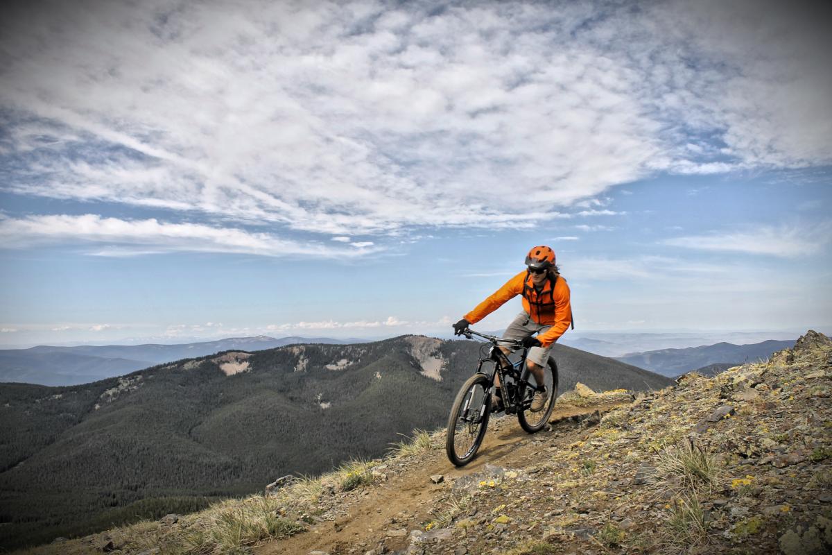
In my last blog post, I shared sweet seven climbs. But mountain biking isn’t all about cardio-punishment and “character building.” Our work deserves a payoff and gravity pays well! So, for those who prefer to allow gravity to do work for you, I now present my Elite Eight descents. Each provides a huge elevation loss, wicked good fun under your knobbies, fantastic scenery should you dare take your eyes off the trail, and assuming you keep the rubber side down, will leave an ear to ear grin on your face at least long enough for you to open the cooler and crack a cool one!
Otero Canyon, Tijeras, NM

In my last article I described a great climb just east of Albuquerque called Tunnel Canyon and this is its downhill leg. How cool to get both in one ride! After climbing Tunnel and continuing up the more challenging West Ridge, you’ll see a warning not to continue into Kirtland Air Force Base (there are things that go “boom” there). No matter, turn downhill and begin the descent down Otero Canyon, a screaming fast rip through a juniper-lined wash that will give you narrow and twisty, open and fast, and great high-speed huck opportunities. Fear not, timid intermediate, each huck comes with a non-threatening cheater line. Even though you’ve completed a top climb and a top descent, it’s not a huge ride to this point, so if you’ve got the gumption, head back up the Blue Ribbon trail which follows the east ridge and you can have another go down Otero to finish.
Monarch Crest, Salida, CO
Most bikers are familiar with this classic epic, even if only by reputation. The Monarch Crest route provides 38 miles of quality singletrack, most of it downhill; but don’t let that fool you into thinking it’s easy! You start at over 11K feet and climb to 12K before the epic descent. There’s a total of 6,300+ feet of descending (WOW!), but even with a shuttle, you’ll have over 2K feet of climbing, the latter part of which will be roller coaster ups and downs on the Silver Creek trail late in the ride when you don’t feel like pedaling any more. But it is sooooo worth it!
The first 8 miles are above treeline with the most spectacular views; then there’s the drop! If you’re not up for the full meal deal, there are a couple earlier drops into South Fooses Creek and Greens Creek without the additional climbing, but be advised these are steeper, more technical routes.
Palmer Trail/Section 16 Loop, Colorado Springs, CO
Once again, I’ll slip a local favorite in. The climb up Palmer Trail is perfect—a reasonable grade with just enough twists to be interesting and superb views that belie the fact that you’re on the edge of a metropolitan area. Then comes the descent down the Section 16 trail—rocks (one of which I personally christened “13 Stitches Rock”), loose gravel, roots, more gravel, rocky switchbacks, more gravel, then crazy gorgeous views of a mind boggling red rock canyon and even some slickrock. At one point, you drop over 600 ft in half a mile. Bring all the suspension and courage you can. Few can surf the whole thing without a dab.
Rock Creek, Arlington, WY

If you don’t shuttle this one, you’re looking at 16 miles of fire road climbing, but the mountains are wonderful and you’re likely to see more elk than people along the way. Once you start down the Rock Creek trail, you’re in for a wild ride. Life will become a blur as you yank and bank at warp speed down a breathtaking conifer forest. Then the trail comes close to the creek (horizontally speaking—vertically it’s faaaar below—this is not one for those who are uncomfortable with exposure!). There are some harsh scree fields that just love to pinch flat, so bring spare tubes. Despite the lower trailhead being a stone’s throw from the interstate, this is remote country and it sees almost no traffic. Be self sufficient and ready for adventure; this is not a place for the uninitiated.
Line Creek Plateau, Red Lodge, MT

This is another ride that rates very high on the adventure scale and requires a shuttle. How does dropping 3,200 feet in under five miles sound? But wait, there’s more! Before the plummet, you get 10 miles of alpine tundra, crystal lakes, and million-mile views. The Line Creek Plateau remains an unknown gem that should be on everybody’s bucket list!
Big Snowy Mountains Loop, Lewistown, MT

This is one you don’t see coming. The Big Snowy Mountains look like little more than a big lump in the middle of the central Montana Prairie. As you ascend into their heart, you realize you are in a remote, rugged place. After climbing an easier-than-it-sounds 2,100 verts in 5.5 miles, the Big Snowy Mountains Loop will have you ride the crest, detour by a year-round ice cave, and then turn toward the most rewarding descent imaginable, dropping 2,400 verts on only three miles! Time to “Hold On Loosely” and be prepared to absorb a variety of trail features while you grin n’ drool through the ride of your life!
Porcupine Rim, Moab, UT

This is another “no explanation necessary” ride for most bikers. The Porcupine Rim gives you miles of crazy good jeep trail and narrow singletrack on a technical route high above the Colorado River. Cardio animals will loop it with a lot of pavement, but most prefer to shuttle. Taking the classic route will mean you have to start with a stiff climb up some ledgy slickrock, which I actually find quite entertaining. If you’ve got the time, see if you can consume “The Whoe Enchilada” which starts high in the La Sal Mountains on Burro Pass, hits the Hazard County trail, Upper Porcupine Singletrack, Lower Porcupine Singletrack and finishes with the classic Porcupine Rim for a sick, sick, sick 7K feet of descending!
Downieville Downhill, Downieville, CA
Here’s another one you’ll want to shuttle—if your hands don’t get too cramped from riding the brakes, you can easily do two laps in a day! The classic Downieville Downhill delivers almost 5K feet of descending on every kind of singletrack imaginable, all of it USDA choice! I defy anyone to ride this and not seriously consider selling all worldy possessions (except the bike, of course) and becoming a Downieville bike bum. If the unimaginable happens and you tire of this one, simply hit the parallel Big Boulder trail for a reset.
No matter what elevation you start at, a great descent leaves you higher than when you started. Where do you get high as you get low?


22 Comments
Nov 29, 2012
Nov 29, 2012
I'm kinda surprised you chose Section 16 over nearby Jones Downhill. Both are great but obviously Jones is much longer.
Trying to think of great descents on the east coast and I'm drawing a blank. At least, there aren't many descents of the caliber mentioned in your list. I guess Green's Lick in Pisgah/Bent Creek and maybe Bear Creek/Pinhoti here in Georgia...
Nov 30, 2012
Nov 29, 2012
Nov 29, 2012
Reddish Knob, a climb I mentioned in the previous blog post, also makes a fine downhill. Lost of vert by Eastern standards and much of it high quality singletrack.
Nov 29, 2012
I figured a lot of folks in the know about Colorado Springs would automatically assume Jones Park would be the epic descent of choice.
1. I opted to go with "the trail less traveled."
2. Jones Park gravel has become soooo deep as to take much of the fun out of the ride.
3. Jones Park requires either a very long shuttle (up Old Stage Road) or a very long climb (up Gold Camp Road) or an absolutely vicious climb/hike-a-bike up the St Mary's Falls Trail.
4. The ruts on Jones Park have become very deep and very narrow, also taking some of the fun out of the descent.
On a related note, the USFS has accepted recommendations to close Jones Park/Pipeline to motos to protect the Greenback Cutthroat trout (which, btw is a non-native species). Fear is the environmental group behind it will go after MTBs next.
Since we're having a warm, dry winter, the whole route is still open, and the plan is to have my wife shuttle miniskibum and I up there this weekend. I'd hate for it to close without Miniskibum having had the opportunity to ride it! He came down Pipeline with me this summer and loved it, so I want him to hit the longer traditional Jones Park route while he has the chance.
Nov 29, 2012
I live in the Springs and I think I have ridden parts of it but not the awesome decent you speak of. If theres any way you could explain the route you take that would be awesome!
Nov 29, 2012
Those left forks head down to Red Rock Canyon open space via a portion of the Intemann Trail, so you can also make a really excellent figure 8 combining loops at RRC and Sec16 into one mega climb and rockin descent. I live at the lower end of Bear Creek Regional Park, so I usually start my ride there and ride up through the park, including the fun, technical Stephainie's Trail, then access the Section 16 loop for a really cool, almost all singletrack, lollipop loop right from my front door!
Dec 1, 2012
Dec 2, 2012
Shoulda' joined you on Section 16 instead!
At least Miniskibum (and I for that matter) had a great time and enjoyed the crazy perfect weather in December!
Nov 30, 2012
Nov 30, 2012
Nov 30, 2012
Skibum, you've GOT to get to Crested Butte this summer!
Dec 1, 2012
Nov 30, 2012
Nov 29, 2012
Nov 30, 2012
Nov 29, 2012
Nov 29, 2012
Edit: Just checked the map again last night and it shows the total at 35. Sorry about the misinfo!
Nov 29, 2012
Nov 29, 2012
check them out here at singletrack.com
Warm Springs Ridge, Sula MT. 12 miles 1600 up 4200 down. All singletrack.
Stein Mountain, North Fork ID. 5 routes down, 8ish miles 5000' down, 500' up. All singletrack.
Three Mile Ridge, Gibbonsville, ID. XC ride on CDT w/ a 4 mile/3200' singletrack drop at the end.
We have a lot more of those around here...several 5000+, those are the 3 best.
Nov 29, 2012