This trail encompasses several trails including Burro Pass, Hazard County, and Porcupine Rim. You start out at 10000ft, and climb about another 1400 to Burro Pass, then the downhill insanity starts. Thru wooded forests, Aspen Pine lands, creeks, then down open prairie land and thru miles of technical really fast, crazy steep and slippery single track until you get to the Upper and lower Porcupine sections, then you finally end up at the Colorado River. This is the most technically diverse and by far the most fun ride I have ever done. I don't believe you could find one ride that has it all like this does.Took about 5 hours, but we stopped a lot for pictures, scenery, and just to in general take it all in. Amazing ride....
 | Burro Pass | 4.3 mi | |
 | Geyser Pass Trail | 1.1 mi | |
 | Hazard County | 2.7 mi | |
| Jimmy Keen | 6.4 mi | |
| LPS Cutoff | 0.1 mi | |
| Notch | 0.5 mi | |
| Porcupine Rim | 3.4 mi | |
| UPS And LPS | 3.9 mi |


 10
10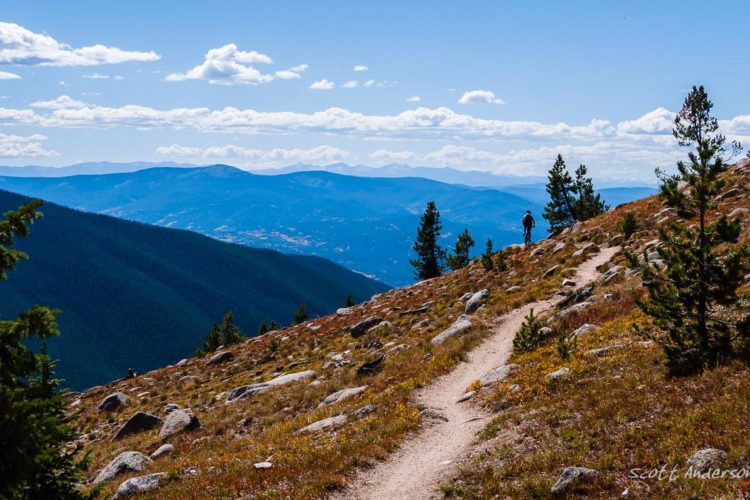


The climb at the beginning is around 1000' and you'll descend twice that to the highway. The trail is around 15 miles so all the numbers on this page are wrong! At the top the view is great so take your time. You quickly descend with drops as big as 3'. Bucket list ride for any mountain biker. Sandstone makes for great traction.
| ThankThis is truly an epic ride, the most diverse trail I have ever ridden. Riding it in October with the temps in the 70's and the leave turning makes this an unmatched trail. Best overall bike trail I have ever ridden.
| ThankAmazing views! A nice transition after Hazard County, hitting up the start of some slickrock integrated into UPS, and more as the descent continues into LPS and then Porcupine Rim.
| ThankThe trail is a very enjoyable day trip if you are spending time in Utah. The view will blow you away!
| ThankThe first half of the trail, even though it says only 3 miles of uphill on the map, is sandy boulder filled 4x4 track. once you get to the top you've already passed many great views. The downhill is lots of rock gardens and alot less sand. Its doable on a hardtail but even on my enduro full it was brutally bumpy being 5 miles lf downhill rocks. Don't get me wrong it was still fun just putting it out as a word of caution. the singletrack along the cliff is the most technical part and is just as fun in its own way. really glad i hit this trail.
Its a must ride in moab
| ThankThe top of the Whole Enchilada. After climbing to the top (part hike-a-bike), the downhill starts at treeline and is steep and loose. After some creek crossings in a softwood forest, you hit the aspens (golden in the fall) and thing s level out. This area is beautiful, but what's with those unexpected climbs? Great ride!
| ThankAmazing. I rode this as part of the Whole Enchilada. UPS and LPS are amazing and unique. The Rim Road can be as difficult as you want. Take the easy route around obstacles or hit the big drops. The final singletrack section is great riding with epic red rock views of the Colorado River and puckering exposure. Great ride!
| Thank4th time down. Started at UPS this time due to
| Thanksnow up top. Come before the middle of September if you want the Whole experience. WE is my favourite trail in the world. Never ever
disappoints. It is epic. NOT FOR BEGINNERS!!! You will get hurt or walk 20 miles.
one of the must ride trails of all time, just for its diverse scenery change itself it earns itself 5 starts.
| ThankThe whole enchilada is unique in that you get such a variety of trail types, but overall I think there are more fun trails to ride.
| ThankDefinitely an epic ride
| ThankNo way the entire Whole Enchilada is an intermedieat trail in fact there is not part that is intermedieat. It is great one of the hardes things I have done.
| ThankWonderful place. Absolutely in heaven the whole time. I now see why this is a bucket list ride. So much better than the local slick rock trail that is better known in the area. Some consider it peddly, but thems just be the out of shape folk. Even when you're peddling, if you aren't on one of the uphill sections, you can still be running a big ring and hammering the nasties. I was running a 6" 29er and was in absolute heaven. When you finish youll have a gentle ride a the river back into town epic! Love this place.
| ThankOverhyped? Good trail, but not the best in the US. Scenery was great, but very peddley for the amount of descent. Most of the drops are blind, except for the copious amounts of black skid marks on the rock.
| ThankHiline in Sedona is better in my opinion.
Rode this in early September last year. There is a reason this is considered Mecca for mtbers. This is a epic trail and experience. One of my favorite times on a mountain bike, ever. Hard to get a lot of flow going because we had to stop constantly to take pictures : ) Even though it is well hyped and lives up to it, this is a serious ride and should be taken very seriously. As another post pointed out this is advanced riding, not intermediate trail. There are parts that are relentles and require fitness and skill to ride well.
| ThankSuch a great trail, bucket list. Started in the trees, ended in the rocky town of Moab. My favorite trail by a mile. Nothing like it
| ThankAt the time of writing this, the singletracks description shows The Whole Enchilada as an intermediate trail of 26 miles... I rode 34 miles from the trailhead back to northern Moab. It needs advanced riding skills - it's not an intermediate trail. And you need to be fit and hardened up with lots of recent riding - this trail throws sustained juddery, rocky, technical riding at you for nearly 30 miles.
The trail and the scenery varies with each passing mile. The panoramas are stunning and often other-worldly. It's a magical trail but there is one long section of bumpy double-track that does become tiresome. You will have forgotten it by the time the Colorado River comes into view way below as you ride around a cliff face before descending to the road.
| ThankYes, it's what everyone says. Don't be fooled by the elevation profile - it's not like 4 lift serviced rides strung together or the Downieville Downhill. A lot of work, consistent moderate technical riding, and mid-day scorching desert heat when you drop into Porcupine Rim. Save some extra water, food, sugar for this section especially if riding in summertime. I saw more than a couple riders unprepared for this.
| ThankAfter going to Moab 4 years earlier for the Whole Enchilada and breaking my heel while rock climbing and before doing WE, it was satisfying to finally check this off my list. On July 2, 2017, myself and 2 buddies rolled into Moab and rode WE bottom to top and bottom again. We rode out of Moab on about 22 mikes of pavement before the final 10 miles of gravel and about 1-2 miles of Singletrack. The top is over 11,000 and In the mid-40's. All snow was melted from the trail but some was still where drifts had accumulated. The trail starts with some steep descents down Burrow Pass. The rest of the trail features everything from slick rock to gnarly rocky sections to awesome dirt through aspen groves. There were a couple of hike a bikes for non-technical riders from Michigan. Views were outstanding. Temperature at the bottom was pushing upper 90 degrees. Hydration is a challenge when not using the shuttle service. Fortunately we brought a water filter and refilled our bottles at a mountain streams. You pass over a few of them near the top. Ended up with 63 miles and 8,500 feet of elevation climb. This trail was an absolute blast and has some riding for everyone.
| ThankThis is my personal best trail. I rode it few years ago and haven't found better place to ride yet. Over 20 miles of sweet downhill with great views. What could be better?!
| Thank