×

|
Rate it:
Tags:
Level: Intermediate
Length: 9 mi (14.5 km)
Surface: Other
Configuration: Loop
Elevation: +470/ -567 ft
Total: 24 riders
Mountain Biking South Fork Trail
#112 of 412 mountain bike trails in Georgia
The trail starts on the GA 64 and climbs to the top of the mountain. About 4 miles on GA 64, the trail turns off to the right as single track. The single track is well marked. After about 6 miles it crosses the Jacks River. Then it intersects with GA 126. Turn right and climb back to the start.
First added by darrengriffith on Jun 14, 2008. Last updated Apr 28, 2020. → add an update
Before you go
- Drinking water: unknown
- Lift service: unknown
- Night riding: unknown
- Pump track: unknown
- Restrooms: unknown
- Fat bike grooming: unknown
- E-bikes allowed: unknown
- Fee required: unknown
This trail information is user-generated. Help improve this information by suggesting a correction.
From Blue Ridge take GA 5 north for 3.7 miles. Turn left of Old GA 2. After 10.2 miles park at the Watson Gap intersection.


Loved the remoteness of this trail on vacation! rode it with Mountaintown Creek and Pinhoti! Can't wait to go back and ride more sections! This area is great and what Mtn biking is all about!
| ThankOn Friday, 01 August 2014, I rode the Pinhoti - South Fork loop in a remote area of the Cohutta Mountains. The nearest towns are Blue Ridge and Ellijay. I chose to get to the trailhead by traveling west from Ellijay 9 miles and passing by Mulberry Gap Mountain Bike Get-A-Way (see first of 15 photos here https://flic.kr/p/ogJFpi ) .
I parked at a rather nice trailhead parking lot at Buddy Cove Gap: https://flic.kr/p/owc2hC
The Mountaintown Creek Trailhead is also co-located: https://flic.kr/p/ogJp55
It is necessary to ford the South Fork of the famous Jacks River about 2.9 miles into this loop route: https://flic.kr/p/ogHPmL
The trail also passes by the northern terminus of the Pinhoti Trail: https://flic.kr/p/ogJeqf
The photos in the 15 photos series all contain additional information: https://flic.kr/p/oydJAe
The trail(s) were in good shape. Perhaps avoid this loop after heavy rains? It has been relatively dry and the boggy areas were still quite soggy; I almost had to put a foot down a few times.
| ThankMore of the same pinhoti. Did this w/ bear creek and mountaintown creek. Was epic. There did seem to be some equestrian traffic and whatnot so conditions have degraded.
| ThankThe South Fork is a fun ride that is super remote and runs along the border of a wilderness area for some of its length. The singletrack section is pretty rocky and challenging and can be crazy muddy in some spots due to chronic boggy areas and stream crossings. Combine this with Mountaintown Creek for a truly epic ride!
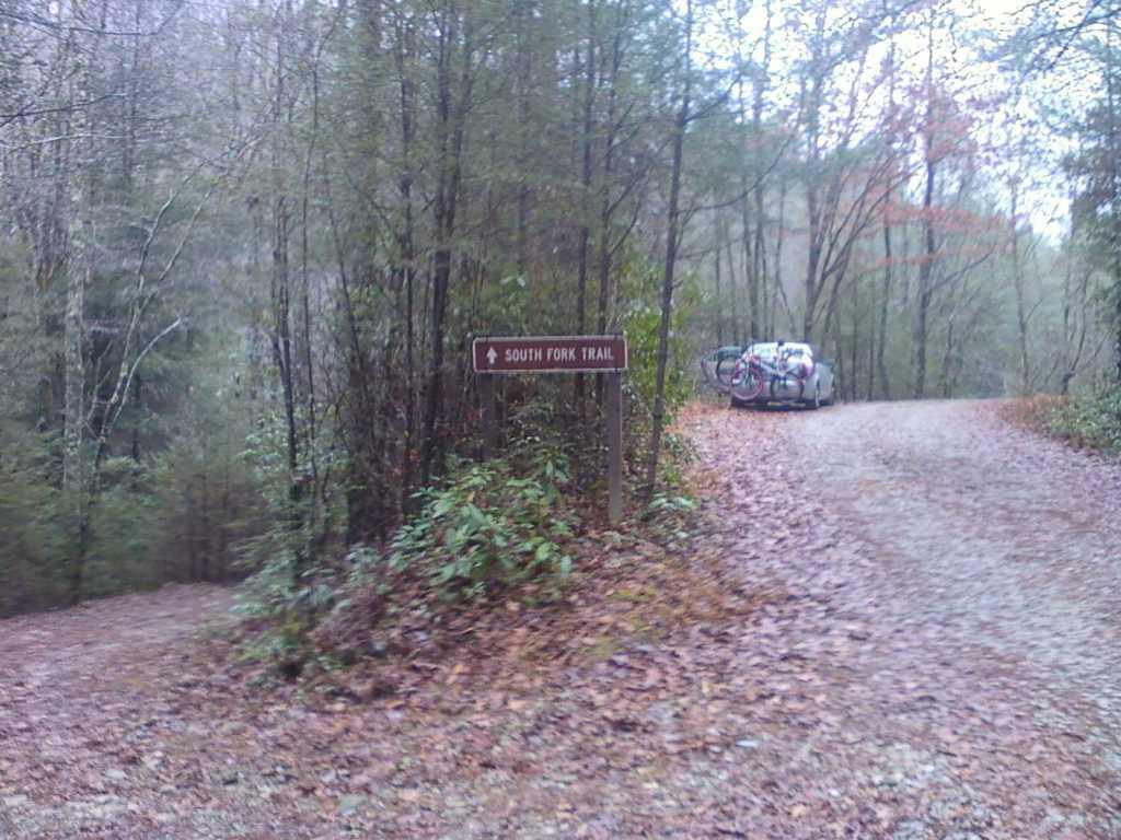
| ThankThe South Fork trail is a 2.7 mile stretch of single/doubletrack that runs north/south between Ga 126 and GA 64. The Pinhoti Trail connects to the South Fork trail about 1/3 of a mile from north end and the two trails merge until the Pinhoti reaches it's northern terminus at the crossing of the Benton MacKaye trail. There are numerous ways to make a loop out of the South Fork trail but I like combining it with the Pinhoti for a majority of single/doubtrack riding rather than doing the majority of my ride on Ga 126 and Ga 64; both of which are gravel forest roads. Instead of parking at Watson Gap, keep driving down GA 126 until you see the sign for the South Fork trail. Park there and start your ride. Stay left on the South Fork trail when the Pinhoti enters from the right. South Fork will dead end at GA 64. Make a right and climb two miles up the gravel road until you reach the Mountaintown Creek trailhead. Make a right and follow the signs to the Pinhoti trail. It will start out as an old road bed that has been reclaimed by nature and is covered with grass and brush. Stay left at the fork about a mile in. Look for the white blazes and the white diamond signs with turkey foot prints and you will know you are on the Pinhoti. About a mile later the Pinhoti turns back into singletrack until it dumps back into the north end of the South Fork trail. This loop is about 7.5 miles and 5.5 are single/doubletrack. Relatively easy riding that any intermediate can handle but the climb up to the Mountaintown Creek trailhead will be an aerobic challenge for most anyone.* Review edited 11/26/2010
| Thank