×

|
Rate it:
Tags:
Level: Intermediate
Length: 8 mi (12.9 km)
Surface: Singletrack
Configuration: Network
Elevation: +849/ -544 ft
Total: 37 riders
Mountain Biking Riverbend Park
#198 of 554 mountain bike trails in North Carolina
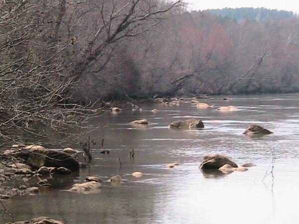
Riverbend Park is a county-owned park on the banks of Lake Hickory. It offers activities such as picnicking, hiking, and of course mountain biking.
The mountain bike trail marked with blue markers is very technical. I would not recommend this trail for the beginner. The trail has very steep, technical downhills followed by heart-pumping climbs. Sections of the trail have some big air potential and some damage potential for the bike and the body. Very scenic sections along the lake side of the park.
The total mileage of the blue trail is 4.5 miles, but more mileage can be added by riding the green trail. This trail is has some of the best singletrack in Catawba County.
First added by videl_majin_cold45 on Oct 29, 2006. Last updated May 11, 2020. → add an update
Before you go
- Drinking water: unknown
- Lift service: unknown
- Night riding: unknown
- Pump track: unknown
- Restrooms: unknown
- Fat bike grooming: unknown
- E-bikes allowed: unknown
- Fee required: unknown
This trail information is user-generated. Help improve this information by suggesting a correction.
From I-40, take Exit 132 "To 16 Conover-Taylorsville". At the top of the exit ramp go north to first intersection (this is a stoplight at Hwy 16). At the intersection, turn RIGHT on to HWY 16 North. Go about 7 miles and look for a Dollar General/Exxon on your right. Continue on Hwy16 North about 1/2 a mile and look for a green park sign that says Riverbend Park - the park entrance is on your right. Park in the parking lot and sign in at the bulletin board. Pedal to the "Overflow/Trailhead" parking lot and take a right - Look for the trailhead marked with a blue marker.
Park Office Phone: 828-256-9157 or Web for hours (closed on Wednesdays): http://www.catawbacountync.gov/depts/parks/rbndmain.asp


Not a great bike trail... this is a wide single track doesn't have great flow to it barely any downhill lots of peddling here. If you are looking for a trail to get some exercise or get started at mountain biking then this trail is for you but if you want to do something more advance with technical spots good downhills and flowy terrain, do not go here!
| ThankConsists of Blue trails (more difficult) & Green trails (easy). My difficulty rating is on the Blue trails. There are trail maps at the site, as well as trail markers (color coded) and map stations located mainly on the Green Trail. Trails cross and intersect each other, so it gives you a lot of options. There are no stunts, no jumps, or anything of the sort. Can log lots of miles when combining the trails.
Blue Trail: Fun. Fast in areas. Fairly Technical. Moderately rooty. Some rocky areas. A good amount of climbs. Quick downhills; a couple which are a bit steep. A few narrow water crossings. Good cardio workout.
Green Trail: Fun. Fast. Beginner friendly. More like fireroads than trails. Wide. Not technical. Long, fast downhills. Long, fairly steep climbs (tough climbs). Nice scenic river area, and ponds to ride around.
| ThankPros:
| ThankThis is probably the most WELL-MARKED trail I've ever ridden. There are trailblazes everywhere along with 'mapstands'(see photos) they have maps posted along the trails throughout the park - almost like a "You are Here" like in a shopping mall!
Some fun downhills, the doubletrack downhill is easy(see video) and long enough to amass decent speed and some natural erosion controls to catch air on...as for the singletrack descents, use caution on your 1st time out- there are some quick turns at the end of some hills where you can run out of trail quick. I went completely when off the trail in one spot. There are also some short but steep climbs. As for the park...nice river views, fishing, picnicing and a dog park looking out on the Catawba river just below the Lake Hickory Dam. Easy to find from I-40(see photos for landmarks), about 10-15min north...good to hit for a ride and picnic lunch, if you're passing through. First-time visitors ride for free.
Cons: The trail was in disrepair in some areas(6/2007), alot of tinderwood littering the trail and I experienced a couple limbs down across the trail. The first mile or so of singletrack is tight and rooty, but it smooths out in many sections after and gets faster. The trail network does not appear to have any set route-and appears to be two-way. While the signage/maps are great out there, there are forks which may give you pause of "which way now?" If you want to do all of the trails(blue & green) this will probably require some overlap.