×

|
Rate it:
Tags:
Level: Beginner
Length: 12 mi (19.3 km)
Surface: Singletrack
Configuration: Network
Elevation: +545/ -553 ft
Total: 229 riders
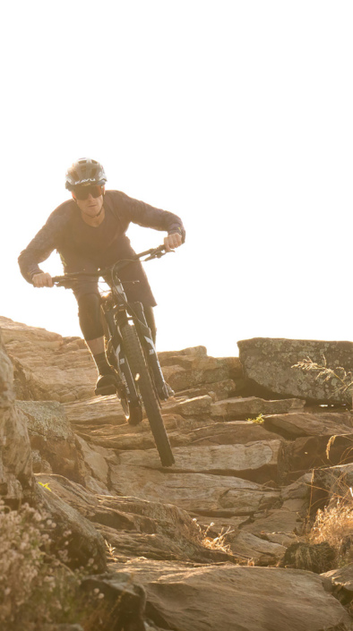
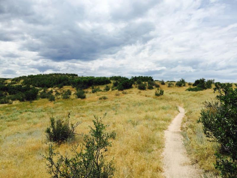
Mountain Biking Ridgeline Open Space Trail
#146 of 1,395 mountain bike trails in Colorado
This trail system is all singletrack. There is nothing technical other than switchbacks, and it has some short but steep climbs. Access it from any trailhead, pick a loop and do several laps.
The climbs are good exercise, the switchbacks keep you on your toes and the view of the front range is amazing.
If you live in the area, this is a great after work ride, or for getting in shape after a long winter.
The official town trail map is here:
http://www.crgov.com/Files/Ridgeline Open Space Map.pdf
First added by Corey Maddocks on Apr 10, 2009. Last updated May 6, 2020. → add an update
Before you go
- Drinking water: unknown
- Lift service: unknown
- Night riding: yes
- Pump track: unknown
- Restrooms: yes
- Fat bike grooming: yes
- E-bikes allowed: unknown
- Fee required: unknown
This trail information is user-generated. Help improve this information by suggesting a correction.
Take exit 182 from I-25 and head west for 1.5 miles.
Turn right on Coachline Rd and go 1 mile.
Turn left on Foothills Dr and go .4 miles.
Turn left on Clear Sky Way and go .25 miles.
park at Bison Park on the left and access the trail from any of several trailheads within a block or two of here.


Great trail system for in town. The trail is all singletrack and is cut in such that the moderate climbs are never difficult and the pay off is an abundance of flowy riding. Joined up with Phillip Miller Open Space, this is a real gem. Great job Castle Rock. I'll be back, but only on weekday mornings. If you have two steeds, leave your big, long travel bike at home.
| ThankThis is a GREAT trail. I am new to mountain biking, so this trail was perfect. I will definitely be back.
| ThankGreat trail right near town.
| ThankA great trail to ride. Lots of connecting loops and accessible from Phillip Miller Park which has its own trails. Just a few minutes from 105 Brewery.
| ThankAdvanced beginner trail; easily accessible and every short steep climb is rewarded with flowing downhill sections. Great spot for flatlanders wishing to become acclimated to higher elevations.
| ThankThis trail is in my backyard (almost). I have easily logged 200 rides here and with respect to the Pros who ride and discount the Douglas County Trail system as beginner or non-technical, I get it but there are some areas that are a quick technical and eroded due to overuse and drainage issues. Many reviews are spot on. Things to be aware of-
| ThankMany hikers/bikers during peak trail times. When the scrub has the leaves, be cautious at the blind turns, etc. and most importantly, respect the conditions this time of year NOV-MARCH. There are many stretches of the trail that do not get adequate sunlight and are muddy/eroded when 75% of the trail is bone dry. As time has shown, these problem areas take time to smooth out when the longer days return. Best Winter riding is after a snowfall before the melt sets in or early am (damn cold though) to minimize the impact.
This trail is in my backyard (almost). I have easily logged 200 rides here and with respect to the Pros who ride and discount the Douglas County Trail system as beginner or non-technical, I get it but there are some areas that are a quick technical and eroded due to overuse and drainage issues. Many reviews are spot on. Things to be aware of-
| ThankMany hikers/bikers during peak trail times. When the scrub has the leaves, be cautious at the blind turns, etc. and most importantly, respect the conditions this time of year NOV-MARCH. There are many stretches of the trail that do not get adequate sunlight and are muddy/eroded when 75% of the trail is bone dry. As time has shown, these problem areas take time to even out when the longer days return. Best Winter riding is after a snowfall or early am (damn cold though) to minimize the impact.
Fun Ride, careful bombing downhill, lots of hikers and runners
| ThankSo the rating says beginner but I honestly feel that's a bit if a stretch with the amount of climbing and switchbacks. Perhaps if you stay only on the top but I'd hate to see a newbie biker get out there and get discouraged. Beautiful trails and views and well worth the effort!
| ThankPlenty of options to link up differing rides from time to time. Not overly crowded, despite being close to town.
| ThankSmooth and flowing single track. My favorite place to ride in town.
| ThankA nice local trail. Great for fat biking in the winter time. Please take care not to ride when muddy. Can get crowded with hikers and trail runners on weekends.
| ThankLike most Douglas County Open Space, there's nothing of technical interest here; even the switchbacks are broad enough as to not require special technique. Having said that, I do like this trail system better than it's counterpart across the street (Ridgeline Open Space) as the trails are narrower and not so groomed. They also have more berms and drainage crossings that allow for some air time.
Pro Tip: Provided it's dry, try to ride this in late fall, winter or spring. There's lots of scrub brush that makes for blind corners which really demands speed control--however, when the bushes are bare, you can see around the corners better an maintain momentum without threatening other trail users.
| ThankThis is a great XC stacked loop system. You can gain plenty of speed. This trail is well used and frequented by runners and hikers so make sure to ring your bell on blind corners. There are plenty of snakes also (I ran over my first rattler here so be cautious).
| ThankThis trial is a great beginner single track. The only downside to it is that it is busy, and with the blind corners you have to be cautious when taking them.
| ThankGreat trail. My favorite thing about this trail system is how diverse it is. You climb up on the ridge and its rocky/sandy open prairy. Then drop down into the valley where its hard pack and dust low bushes and scrub oak. Then back up, and back down.
| ThankNot too technical but varyied.
Just a really good time.
Although I would recommend bringing a map before you come. It's easy to get turned around and go the wrong way, and the trail head was out of maps.
Great network, perfect for a beginer to practice on intermediate skills. The challanging areas have no consequence, so you can try harder sections without fear. Take a beginer who wants a challange, you will have fun also, great trail and beautiful scenery.
| ThankHave to give it a 3 because its my backyard and I've ridden it 50 times. Ridgeline is race #1 of the Rocky mountain Endurance series called Ridgeline Rampage. Theres about 12 miles of nice flowy Single track with a few climbs that will get u pumping but are short. Great views of most the front range. Can get a lot of hikers and runners up there so mind your manners. Careful on the blind switchbacks.
| ThankThere is a lot of overgrowth from the rains over the last few months, which has made for a lot of blind corners. Combine that with the loose sand and it gets a little sketchy.
| ThankHas alittle of flow. Your riding in hills so its alot of short up short down. Its not very rocky now technical but its a fun place to check out if you live in the front range. Great views of the front range!
| Thank