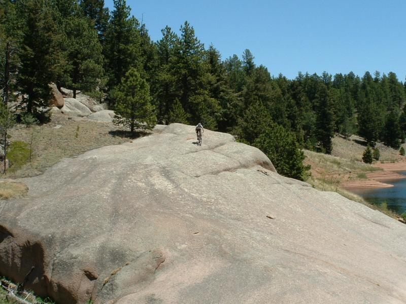
This trail is an excellent ride for riders of almost all skill levels. The scenery is excellent, the trail is fast yet technical, and the length is just right. The only problem is, some of the other users of this trail aren't too friendly (depends). Anyway, to avoid any dirty looks, etc, ride this route clockwise. Follow the double track / dirt road down from the trailhead. At the bridge on the right, CONTINUE straight to do this loop in an acceptable manner. There are alot of side trails here but as long as you stay close to the lake front, you will not get lost. This trail reminds me of some east coast rides, particularly lake rides like Tsali and Owl's roost. Lots of trees, lots of technical sections involving large rock formations (although each of these can be avoided by taking an alternate route around them). Keep your eye out. Oh yeah, and be courteous. When someone yields trail to you, say thanks, say hello when you pass, etc. A great ride.
You can also go camping nearby at Meadow Ridge.


 6
6

Great ride today. Very fun up and down around the reservoir. A couple areas I had to walk but did see trails that would avoid those areas. Beautiful day and trail!
| ThankOverall a great ride, even though there were some slippery/steep places I had to walk my bike through (maybe 150 feet at most, spread around the loop). Good mix of technical sections with smooth, fast areas. Not for beginners or younger riders. Great views all around the lake, too. A fun ride.
| ThankThis is a really nice trail, some smooth flowy sections, some very technical rocky sections, big rocks, and a lot of loose fine gravel on the trail. We had a lot of fun, but had to walk the bikes through the really tough spots. Watch the blind corners or be surprised by hikers. A couple sections are very close to lake and steep, Slide off the trail here and end up in the lake. Crowded on weekends.
| ThankThe VIEWS are nothing short of spectacular. I did the entire 16 mile loop and although I hiked a lot, it was worth every minute of effort. I am a low to medium intermediate weekend warrior rider that enjoys a good endurance challenge. This trail was almost too much for me going counter clockwise. (But hey i finished!) As a previous reviewer mentioned, there are some areas that must be done carefully or you could die. He was not kidding. In some areas (way less than 1% of the trail)one wrong move and there would certainly be carnage. I felt some adrenaline kick in but did not really think of the potential loss until afterwards. Lol. If you are super careful ... no worries, but I would not recommend inexperienced riders of any kind and no kids on bikes - there are some narrow areas that could lure someone into suddenly making a mistake.. There are also some areas you will have to hike and may present extreme difficulties for someone with a bike (narrow, steep, slippery with gravel). I am sure expert riders out there might think I am overstating this difficulty, but unless you like going up and down 70 degree vertical inclines over sand and gravel through and over pure huge rock formations... you will definitely be experiencing a hiking challenge. Even still I give this trail a 4 because it is purely exotic.
You'll be so hypnotized by the surrounding beauty that having a smooth ride wont matter and if you keep moving you can finish the 16 miles in less time than someone just hiking. Took me and my adult daughter(18) about 5 hours including an hour or so for fun time near the water, granola bar breaks, and just time to soak in the scenery. As with all Colorado Mountain biking it's best if you can leave in the morning hours, but we did this starting at noon and enjoyed the blazing sun and high 90 degree temperatures. Fortuntately, the cold breezes off the visible snow capped mountains and ice cold resevoir kept us cool most of the time.
If you like a challange and like great Colorado scenery, you will want to add this to your must do list.
*** note: the directions through singletracks lead you to the trailhead at a nationional forest campground which requires a fee of entry of $6.00 cash or check only per car. However, if you can make it to the Dam to park, it may be free.
| ThankI haven't been riding very much lately and had a good time on the trail. It was a little tricky since I hadn't ridden it before with coming around corners and being on top of technical parts but those would get easier with repetition.
| ThankBeautiful trail. Some water crossings and technical spots. But overall very rideable. A must ride trail for the Pike's Peak region !
| ThankExtreme...there are places that will Kill ya..! Maybe it's washed out some - but still Extreme and Tricky - be ready.
| ThankGreat trail around rampart reservoir. Beautiful views of Pike's Peak.
| ThankSome technical spots on the north trail of reservoir. Great place to camp and mountain bike !!!
I rode this trail for the first time today, and can't wait for my next chance to do it again. I almost didn't bother giving this place a chance because of a few of the reviews on this site and other sites from people claiming to be advanced mountain bikers and exaggerating the amount of hike a bike stuff. Seriously, almost the entire trail is ride-able. I'd say I am an intermediate avid mountain biker and I probably only walked about 100ft of the 14 miles, at the most. Furthermore, many of the short sections that I did walk I think most intermediate to advanced riders could clear them if they tried a couple times, or rode the trail a few times and started getting to know where the the short rocky sections are at and geared down appropriately.
The trail is mostly fast and curvy with minimal climbing. I am actually really grateful for the short technical sections that show up intermittently that keep things interesting. The scenery is awesome as well, and only makes the ride that much better. Hard to find a better place than this, feels remote, green trees, beautiful lake, and Pikes Peak in the background.
| ThankBeautiful trail and surrounding scenery. Some easy parts and some hard parts. Technically challenging at the 2/3 mark and not for beginners.
| ThankHorrible tone the trail is a mess riddled with obstacles that are too worn to bypass on a bike. Not a very user friendly and watch out for lighting.
| ThankRode Rampart today. It is quite different than most other trails in the Springs area and in CO. There's no long climb, no long, nice DH. There is really nothing notable about it as far as a mtb trail. The elevation at 9000' and distance of 14 mi makes it a nice little training ride.
It would make a very nice day hike with your wife or girlfriend. The scenery is very beautiful, and the lake is just "begging" you to jump in.
| ThankMy wife and I have ridden this trail many times over the years. (THIS was the trail that got her excited and commited to mtn biking, so, guys, take your wife to this one, and maybe you will have a riding partner for life.) Not too much to add from the other recent reviewers. The vast majority of the trail was untouched by last year's Waldo Canyon fire, just a few hundred yards along the south. The views to Pikes Peak aren't what they once were, but the trail retains all of its attraction.
| ThankThis trail opened recently after a fire burned down a large area of the Pike National Forest last summer. Some parts are still closed off but the majority of the trail is open for biking. We rode the trail clockwise from the parking lot and it's an easy downhill to the reservoir from there. Beautiful scenery with a view of the reservoir on your right and a lot of shade from trees and rock formations on your left. Plenty of technical sections to test out your skills or do drills if you're a noob. Some of the rocky sections can be intimidating but they are there to challenge your abilities and keep you engaged. If you are too afraid to go for it for fear of scratching your beautiful, 5k carbon bike then no worries the tough sections are short and you can just hop over and be on your merry way. It says on the info that this trail is 14 miles but it sure did feel like forever when we were up there. After about an hour and a half on the trail we were just approaching a parking lot that lead to a road that you have to ride to get to the connecting path to get to the reservoir loop. Once you get uphill and close to the pick-nick area there will be a sign for a path that takes you back to the reservoir. It takes you through the south side of the trail that was badly burned by the fire which looks a little eerie in the setting sun. Plenty of picture taking opportunities here if you are not in a rush but since it was our first time on this trail and we were loosing light fast we just had do pick it up and ride like the wind. It is very pretty though, so if you have the time to appreciate nature and smell the roses then I suggest you stop to get the feel of nature's destructive and renewing power. It can get overwhelming out there specially when your riding through limited sunlight. Overall, this trail is definitely one of my favorites. It is great for riders of all levels, amazing views and awesome single track only in the colorado front range.
| ThankThey just reopened Rampart Reservoir 2 days ago so this trail is open again! Had a great time riding this trail clockwise today. It's very fast although there's a bit of the usual loose gravel for around these parts. There are technical challenges sprinkled in all the way around but none of them are very long so a quick dab or push and you're back on your way. This is a very pretty trail that goes through lots of trees which means lots of shade and beautiful views. The fire reached the south shore of the reservoir so that portion is a little eerie to ride through. Hopefully there won't be problems with erosion in this area, but I'm afraid there will be eventually. I'd highly recommend this ride to just about any level of rider. You can always turn around and make it an out and back if the total length is too much for you. Fun stuff!
| ThankI first heard of this trail some years ago from a Colorado MTB "ace." He said the trail "sucked" because it was TOO easy. I am not a technically adept rider, so I thought this might be a good fit for me. Like so many have noted, lotsa' hike a bike sections. Not a great overall flow. I wasn't disappointed, but I don't think I will come back. It would nice if some of the more insanely technical sections had bypasses built around them. It took me an 1 hour and 27 minutes to complete the loop. Whenever you see a rock formation coming up on the trail, rest assured that a technical section awaits you. Dismount as needed.
| ThankI just rode the trail today after work. I'm just getting into mountain biking so I found this trail very difficult in sections. I see some of the earlier reviews on here that make it sound so easy. I would love to get tips from those riders, because as later posts suggest, some of the areas are just impossible (at least to me) to be ridden. Having said all that, it only took me 1:49 to ride it, so I was also surprised to see the average time being 2 1/2, since I'm just getting into it.
The trail is beautiful and majority of it is very fun to ride, but be prepared to get mad having to get on and off your bike frequently.
| ThankRode this yesterday, going clockwise. Since nobody seems to be acknowledging this on here, I'll do it. I'm a fairly advanced rider accustomed to east-coast riding, and rode with a friend who is an advanced rider accustomed to riding in Arizona. Both of us had to walk our bikes, I'd say close to 10% of the time on this trail. The trail is deceptively easy most of the way, then suddenly you come upon a completely unpassable section, with another 50 yards later, and another 70 yards later... etc. Great scenery, but I'll honestly probably never come back. There's no flow whatsoever, and if you start to pick up speed, beware. You'll probably have a lot of difficulty stopping when you come upon deadly obstacles. I'd typically WANT to direct other riders toward the trails that I don't plan to ride, but its quite a drive just to be disappointed. Also, lots and lots of people here.
| ThankThis was a fun trail, but a little understated. The trail is easy most of the way, but there are more than a few hike a bike sections without options. I would ride it again but understand it is a long ride and not for the faint at heart. No long climbs no long downhills except the section coming from rainbow parking lot and then coming back. Overall it was a good trail.
| ThankI took my wife on this ride over the weekend, and it might have been a bit much. Overall it was a good ride with a lot of sandy areas that reduced traction a bit on some of the small climbs. It got a bit frustrating getting off the bike and hauling it over and thru the unrideable rocky areas. If the average time is 2hrs and 45 mins we must be pretty slow. The whole ride from the free rainbow lot took us almost five hours. Overall a fun ride when we were riding.
| Thank