


Update 7/22/13 by mtbgreg1:
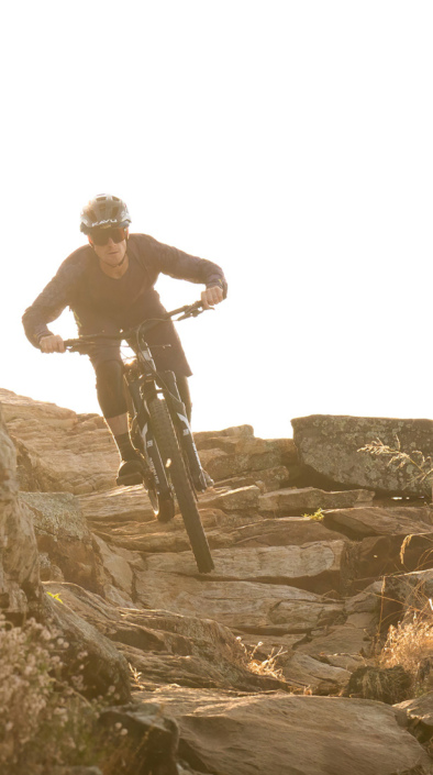
The Phil's Area Trail System is the go-to trail system for mountain biking in Bend. Even the other trails in the region that aren't actually part of the Phil's Trail System feed into or connect to trails that feed into Phil's.
According to the locals, and for the purpose of our trail listings, the boundaries of the Phil's Area Trail System is a square comprised of Skyliners Road to the north, Highway 46 (Cascade Lakes Scenic Byway) to the south, Bend to the east, and the Storm King trail to the west.
This complex trail system offers a variety of different trails, but on average the trails are very buff, very flowy, with some great corners to rail. The trail tread is quite loose and sandy, and gets very dry, especially late in the season, leading to "moon dust" conditions. Here and there you'll find some rock gardens, skinnies, and sections of flow trail with big jumps and massive berms! All of the difficult sections do feature ride arounds, making this an extremely beginner-friendly area.
Previous Listing:
This route goes along a popular trail close to town and is ideal for mountain biking. A lot of the roads and trail names are unmarked so watch for the Bike Route signposts.
Mileposts:
0.0 - Phil's Trailhead. Head west down the wide cinder road FS road 4606.
0.2 - Turn left onto a closed road (Phil's Trail).
0.3 - Bear left at the fork in the road/trail (Kent's Trail) staying on Phil's Trail.
0.8 - Turn right onto FS road 030 (white pumice road).
1.4 - At a pumice pit the trail continues off to the left side.
1.5 - Head straight at the next trail junction with KGB Trail
2.2 - The trail tops out and crosses FS road 4610.
2.8 - At the fork in the trail (Kent's Trail) bear left, staying on Phil's Trail.
2.9 - (For a shorter option look for Voodoo Trail on the right that will connect you back to Ben's Trail.)
3.9 - Upon reaching a red cinder road (FS road 300) turn right. (for a longer option continue up Phil's Trail and coming down Woops Trail. )
4.2 - Look for a trail on the right, take that trail and head down Ben's Trail.
The trail winds and crosses the FS road 900 several times.
5.7 - Fade Left at the junction with the Voodoo Trail.
6.3 - Where the trail crosses FS road 4610 go right and then immediately left, fade left again and just after a few woop de doos look for the start of Ben's Trail on the right.
7.3 - Turn right staying on Ben's Trail.
7.4 - Fade left staying on Ben's Trail (MTB Trail on right).
7.9 - Join Kent's Trail and head back to the trailhead by turning left.
8.3 - Head straight at the junction with Phil's Trail and return to the trailhead.
9.0 - Return to trailhead.
 | Ben's Lower | 5 mi | |
 | Ben's Upper | 2 mi | |
| C.O.D. | 4 mi | |
| E.L.V. | 1 mi | |
| Grand Slam | 6 mi | |
| Kent's | 4 mi | |
 | Kents to Phils, chicken, KGB, Marvins | 21 mi | |
| KGB | 3 mi | |
| Lower Whoops | 2 mi | |
| Marvin's Gardens | 1 mi | |
| Phil's Trail | 7 mi | |
| Pine Drops | 2 mi | |
| Upper Whoops | 2 mi | |
| VooDoo | 2 mi | |
 | Wonderland Trail | 1 mi |


Fun Fun Fun
| ThankPhil's has some good flow and jumps on the "harder" trails, but there are some great beginner trails that you can work on your skills. In addition to a pump track, small jump track, and skills area. Everytime we've ridden here it's been a hoot.
| ThankA short trail connecting C.O.D. to KGB, Grand Slam or Phil's. No more or less fun than most in the system.
| ThankDoesn't matter if you're a beginner or an expert, Phils has something for everyone. the builders/maintainers are awesome, Keep up what you do.
| ThankVery fun flow trail. the trail was neatly groomed, berms where great and the flow was smooth. props to the People that build/maintain all of the trails in Phils area.
| ThankPhils definitely lived up to all the hype. All of the trails in Phils area are very well kept and weren't too busy despite the massive parking lot that was full. We pedaled up Bens trail which is a climbing trail and then descended Phils. Phils was fast and fun, with a fair amount of rocks, roots, and turns to keep it interesting the whole way down. Great for riders of all levels. Can't wait to revisit Bend and enjoy this trail once again.
| ThankFour stars just for the fun factor. The central trail of the Phil's Area system totaling 7 miles of one way downhill flow. Nothing hard about it....just hop on and roll along. One could probably ride the whole thing without pedaling if you wanted just to cruise. Somewhat of a gully in spots due to the heavy usage, but overall well maintained. Great for beginners or anyone finishing a ride from the outer sno-parks.
| ThankAnother fun, fast flowing trail when ridden downhill. A gentle climb if going uphill. Smooth enough for a fit beginner. Less travelled than Phil's so it isn't as troughed making it better in my opinion. Great way to end your ride.
| ThankBen's Upper is actually just a uphill route gravel road/dirt road from Ben's Lower singletrack to Junction post #29. The downhill portion of the ride is Lower Whoops. That is where all the fun is. At the end you can grab another short dirt road to hook up to Phil's, Kent's or other flowing trails leading towards Phil's TH.
| ThankOne of the easier trails in the Phil's system. Great for beginners or warm up for more advanced riders.
| ThankThe trails are pretty easy with exception of Grand Slam. For more information on our ride please visit Mountain Bike Arkansas - www.mtbark.com
| ThankGreat Riding! A must ride when you are in the area, as either a destination or as a part of a more epic all day ride.
| ThankLegendary trail system made even better by a rad group of locals. One of the coolest cycling towns in the country, hands down.
| ThankThis trail system is beautiful but I give it a low rating because the gradings for level of difficulty are WAY off. Their intermediate trails are beginner level, the black diamond trails are easy intermediate. COD was the best trail we rode here and marvins garden has lots of fun little jumps. I would avoid bens trail if you can, it is BORING.
| ThankI gave a 4 because uphill is dirt road, not single track. Otherwise the downhill is a 5 for fun
| ThankFun, good warm-up to climbs. Good trail work
| ThankNot hard, but flowy and fun. Great break in challenge level if you are doing the whole Bachelor to Bend ride. A must ride for everyone in the area.
| ThankGreat Flowing track with lots of shade and technical fun.
| ThankNice easy trail to just about any where in the Phil's system. Slight uphill climb for 7 miles; from there you can turn in a few different directions and access to the heart of Bend's extensive trail system.
| ThankXC heaven! First trail(s) I found in Oregon that did not require a long uphill grind for a fast, furious downhill. Lots of good cross country trails with miles of smiles. I found one ridge that required a fair climb; otherwise it was open riding. Not too technical but fun. The last 4 miles coming home to the TH required neither braking or pedaling.
| ThankTrails are heavily ridden and some spots are a bit worn, but the entire system was a pleasure.