Most will ride up the Laurel Mountain trail and descend down Pilot Rock for a roughly 14-mile, counterclockwise loop. The trail is generally rideable with some steep and technical spots.
Alternatively, start your ride at the trailhead of Laurel Mountain and ride back down Yellow Gap Road to the Pilot Rock Trailhead. Start your climb here. Most of Pilot Rock is unrideable, so its a lot of hike a bike to the top. Once at the top you will connect to Laurel Mountain Connector Trail. Take this trail approximately .3 miles until you see a dead tree laying on the side of the trail that looks like its blocking another trail on purpose. Its not though. Take a right behind the tree and start your 6.5 mile descent and hang on for a great ride.
 | Laurel Mountain Connector | 0.1 mi |


 6
6


Most will ride this as a long grind up to the start of the Pilot Rock descent. Most if not all of it is rideable. The trail lives up to its name with dark tunnels of mountain laurel.
| ThankI'm going to go against the grain just a bit here. Like most reviewers, I believe the route is best done in the opposite direction from the original post. Unlike most reviewers, I'm going to say that, while the descent is pretty rad, it's not so awesome as to fully justify the sweat slogged climb and the road time required to complete the loop. 4 stars is still a pretty good ride; just not the pinnacle of perfection that a full five stars should require.
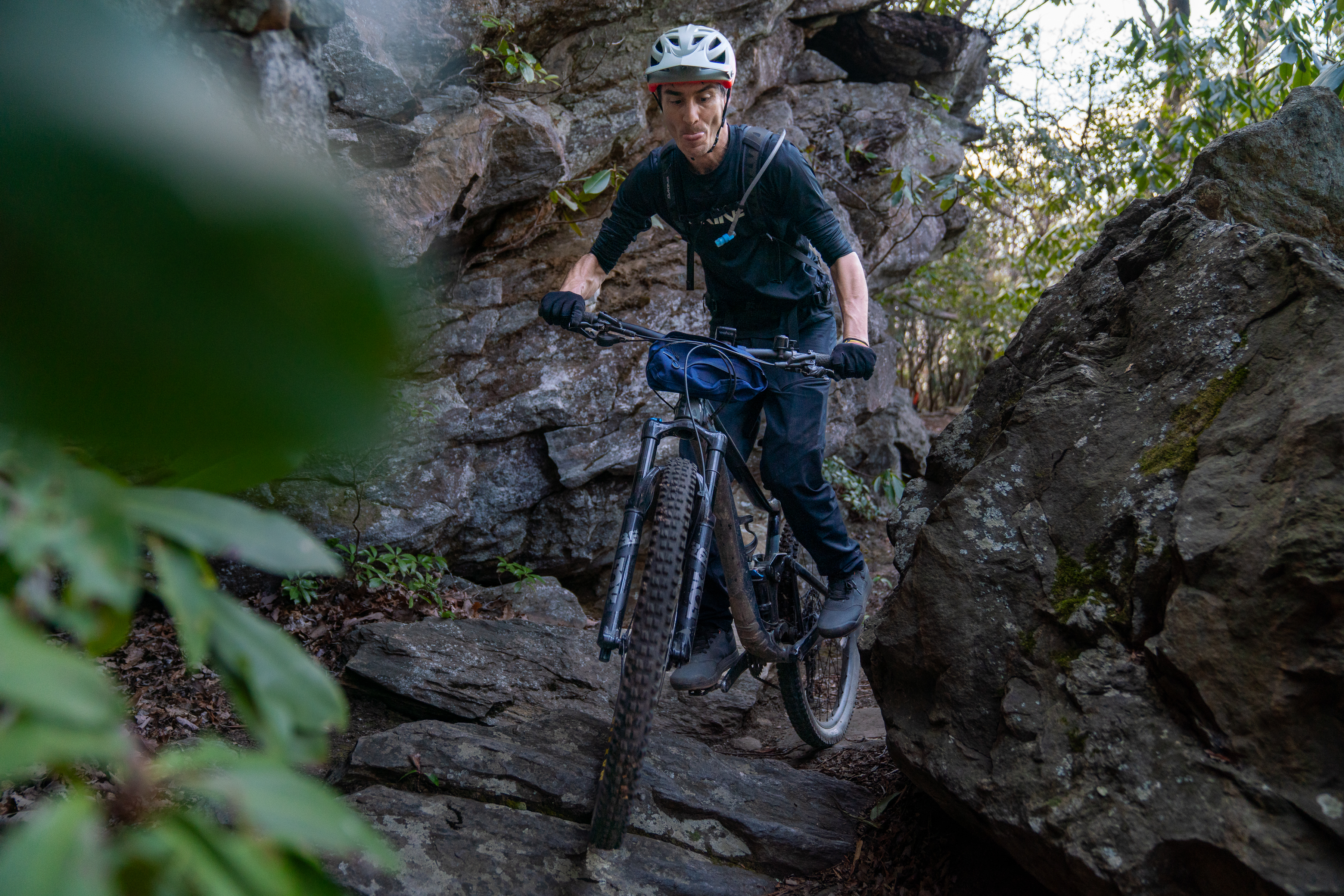
| ThankLaurel Mountain is a time dump, it takes forever to climb this mountain but it is rewarding. The climb is gradual and then gets steeper until a short ridiculously steep hike-a-bike. A little more pedaling leads you to the pilot rock connector, and then lower your seatpost and put your skills to the test. The whole top section is steep and rocky with switchbacks and beautiful views. Most of this is very rideable for advanced riders. Once the rocks end you continue quickly towards the gravel road. This is my favorite downhill in all of pisgah, it's perfectly challenging.
| ThankJust an amazing experience to have done this awesome gnarly and different kind of brutality and toughness. Definitely going back and try to hike a bike from Pilot Rock to hit Laurel Mountain on the descent.
| ThankLong technical climb up laurel but worth it for the amazing downhill on pilot rock. Look out for bears though. Had two very close encounters with some bears on the trail. I think they were eating the blueberries that are up there right now. I was making a lot of noise to spook them away but it didn't seem to work very well...
| ThankAwesome trail. Long climb up Laurel and super technical but fun down pilot rock. Watch for bears though. I was making plenty of noise and still had two very close encounters with bears on and beside the trail near the top of the mountain. There are a lot of blueberries along the trail this time of year, I figured that's why they were there.
| ThankThis is a trek worth taking for those who can climb for extended periods and whose conditioning can take them to altitude, not to mention the technical descents down rocky washouts and switchbacks. I will never forget this trail...fondly. I did lots of hike-a-bike, and the scenery was astounding. At one point, I texted my sons; "I thought I saw Gollum". Some of the trail simply seems magical with mossy trail edges and gnarly laurel branches forming tunnels over the trail. It's a tough ride, but one you'll not soon forget. A full suspension rig would help on the downward slopes for those so inclined, but I managed without.
| ThankAmazing ride! I rode it the direction that the two reviewers below recommended, and I agree that this is definitely the way to ride it.
Recommended route: park at the bottom of Pilot Rock if you want to finish with a descent. Ride roughly East on the gravel road to get to the other end of the Laurel Mountain trail. If you want to add in more singletrack, hang a left on the Pilot Cove / Slate Rock trail (#102) and add in that loop. When you rejoin the gravel road, take a left to keep climbing (or just continue straight). When you get to the Laurel Mountain trailhead, take a left onto the Laurel Mountain trail and climb/sidehill along the ridge all the way to the top of the Pilot Rock descent. Descend Pilot Rock back to your car, and love every minute of it!
Review: this trail is no joke: the climb is extended and technical, but is very rideable for the most part (but of course there are a couple of hike-a-bikes, at least for mortals). The descent down Pilot Rock is straight up a-mazing: this is technical backcountry singletrack at its FINEST! I rode many amazing trails across the country this summer, but this ride on Laurel Mountain easily ranks up there with the best of them on difficulty, entertainment factor, and technical challenge. While it is super gnarly, I disagree with GoldenGoose on one point: I would NOT want a downhill bike on this, for a few reasons: 1) It's in the middle of nowhere and would be a PITA to get a DH bike up to the top of this descent 2)It's not technical enough to require a DH bike. If you have a 6" travel AM bike that's plenty. I rode it comfortably on an older FS with 5" of travel and a too-steep HT angle. 3) The switchbacks are pretty slow-speed and pretty tight. A DH bike might honestly be too long and too slack to navigate those turns well.
Overall, this is an absolutely epic backcountry route with everything you could want thrown in: extended technical climbs, ridgetop riding, great views (if it's not cloudy), and one of the gnarliest backcountry downhills anywhere.
| ThankI've ridden this trail twice, once in each direction.
You will hike your bike a lot during the 1500 ft gain to pilot rock. Someone might prove me wrong, but I'm a pretty good climber and I don't believe those switchbacks are 100% rideable. (Danny McCaskill might be able to do it). You will end up riding 100ft, then hiking the steep switch back, etc. The downhill is pretty fun from the top though.
I STRONGLY recommend riding in the direction opposite the description given. Begin the single track Near "Yellow Gap" off the fire road near the small waterfall and pool (It is labeled 'starting point' on the map I uploaded. Only a couple cars can park there). This direction is 100% rideable if you are a good climber and have technical descent skills. The climb is long with some steep and rooty and rocky sections. Once at the top, the trail turns left, and soon you will descend the switchbacks with a section that is essentially a boulder field ... awesome!! You will end your ride with a bombing fireroad descent too.
I posted a photo of the trail map I used.* Review edited 6/12/2012* Review edited 6/12/2012* Review edited 6/12/2012
| ThankWe chose to ride the trail in reverse of the directions above and it made for a KILLER descent down Pilot Rock. DH bike worthy. Tons of pucker factor, sharp/tough switchbacks, and techy rock sections to navigate. The vast majority of this loop is rideable in this reverse direction other than a couple 200-300 yard hike a bikes near the top of Laurel Mt. We also added the Pilot Cove-Slate Rock trail instead of spinning on Yellow Gap road for 5+ miles. Turn left onto the blue blazed trail near the bottom of Pilot Rock to pick up Pilot Cove-Slate Rock and stay left at at the intersections with other trails. I highly suggest this alternate route as it trades 4 miles of gravel road grind for beautiful singletrack. Lots of roots and loose rocks coming down (or going up) Pilot Rock trail. Laurel Mt trail is much more smooth and is rideable in either direction other that the aforementioned hike-a-bikes at the top. Plan for at LEAST 4 hours of riding unless you are ALREADY familiar with the trails.* Review edited 5/31/2012
| Thank