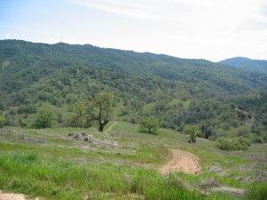
Henry W. Coe State Park (or "Coe" for short) is a large and very rugged park, located in the remote southeastern corner of Santa Clara County, east of Morgan Hill and Gilroy. The good news about Coe is that it contains some of the best downhill singletrack in the southern Bay Area. The bad news is that it also contains some of the Bay Area's steepest fireroad climbs. To best enjoy this park, you should be in fairly good shape. The best time to visit Coe is during the spring or autumn. Summers can be very hot (90-100 degrees), and during the winter, the park's singletrack trails are closed for 48 hours after rain. Whenever you choose to go, be sure to carry plenty of water. The start This loop is best done in the clockwise direction. Begin by taking the dirt road ("Manzanita Point Road") that starts next to the park headquarters. (Don't be distracted by the singletrack that you'll see near the park headquarters; none of this is open to bikes.) Do not take the left turn onto "Hobbs Road" (unless you're a masochist). Instead, continue for roughly another mile, and watch for the "Flat Frog Lake Trail" on the left. (There are actually three trail entrances clustered together on the left of the fireroad. "Flat Frog Lake" is the leftmost of these; the other two are closed to bikes.) The "Flat Frog Lake" Trail This sweet and beautiful singletrack trail winds around the hill, eventually joining "Hobbs Road" (fireroad) near Frog Lake. There are no steep sections on this trail, but it's remarkably narrow for a legal trail, and this makes it a lot of fun. The "Frog Lake" Trail Continue to the right along "Hobbs Road", as it crosses an (often dried-up) creek (the Little Fork of Coyote Creek). Then, after a short climb, turn right onto the "Frog Lake" trail. This singletrack drops down beside a small lake, then climbs up the hillside towards Middle Ridge, at which point you turn right. The singletrack descent (Middle Ridge Trail) You now begin a more than 1700 ft singletrack descent over about three miles. Apart from one short (but steep) uphill section about 1/3 of the way through, the trail is almost all downhill, becoming progressively more technical as it gets lower. You'll also notice the countryside changing: from open grassland to forests of manzanitas and madrones. About halfway through you'll see a trail (the "Fish Trail") branching off to the right. Ignore this; it's closed to bikes. The trail ends beside a creek, in an area named "Poverty Flat". This is a good place to stop for lunch, before beginning the climb back out. The climb out (option 1: more direct, but painful Shortly after crossing the creek, you'll reach "Poverty Flat Road". For the most direct way back, turn right and take this road back to the park headquarters. The first section of this climb is brutal, climbing 1,400 feet in 2 miles. (I call it "the Hill from Hell".) The climb out (option 2: more hassle, but more singletrack & less pain) (This is the alternative I prefer.) Turn left on "Poverty Flat Road", then cross the creek and follow it downstream, along its right-hand bank (i.e., on the side closest to the park headquarters). There's a rough trail here that leads to the China Hole trail crossing. You will have to push or carry your bike most of the way; much of the trail is washed out (being so close to the creek) and almost none of it is rideable. In places you'll have to carry your bike over large boulders. This is a bit of a pain, but the resulting singletrack climb makes it worthwhile. Ride the China Hole Trail up to the Manzanita Point campground, and then back to the park headquarters. This whole trail is rideable, and is not excessively steep. On average, it's no steeper than the "914" trail in ECdM, although it is much longer.
 | Coe Middle Ridge | 12 mi |


 4
4
This is the best mountain bike trail system in Northern California. However, it is not for the novice. You wont see bobcats and mountain lions during the daytime as they are nocturnal in nature. Ride towards dusk and you are sure to see bobcats. The problem with this review is he started his ride at the wrong location. Start at Gilroy Hot Springs. There is a long climb up to the top of the ridge and after that it is pretty easy with the exception of a large downhill to Kelly and Coit Lakes. The good thing about starting at Gilroy Hot Springs is you get all your big climbing completed at the start of the ride. After you ride around the park then it's basically a long fast downhill run back to Gilroy Hot Springs. This place is truly a gem!
| ThankJust had a blast riding those single trails. Steep hills but nice downhills. Clean and technical trails. Love this place
| Thank(This review applies to the main park entrance and headquarters - North Coe).
Are you into extreme fitness and nature walks? Do you like carrying your bike over serpentine rock? This park may be for you. If you're into mountain biking, this trail may not rate high on your list of favorites. There's a great variety of flora and fauna here, but not a lot of exciting riding.
I've just ridden the park in May '11. It was nice to be way out there in the wild, but I prefer downhill that's long and as fun as possible. This was not it - at least not as it is right now, in late spring. The 24-inch grass was covering the singletrack, reducing visibility, which means reduced speed. There were only a few fun parts on Middle Ridge trail - I think there were two particularly steep parts that were so steep I just slid down them - in a fun, controlled, steering kind of slide. It was quite fun actually. But you can't jump off of rocks and roots when you can't see where the trail goes ahead of you, and this took away a lot of the fun. ***
And another huge negative - ticks. I stopped counting at about a dozen that I removed from my legs. Again, this is probably only a problem because of the overgrown grasses on the path (ticks hang out on next to trails, on plants, waiting to pick up their next ride). I had to stop and check all the time. ***
If you're susceptible to poison oak, you'll be in trouble. This is the only trail I've been on where it's all but unavoidable to brush up against it at some point. It didn't cause any problems for me, and I was able to wash up at the creek and the headquarters, but I don't get bad reactions to poison oak. You may. The grass was a problem for my bare legs - if you're mildly allergic like I am, you're going to be itching like crazy and get welts. Again, washing in the creek helped here. ***
If you're into serious cross-country mountain biking, you'd probably enjoy these trails. If you're like me, and you enjoy the downhill excitement more than the uphill burn, there are probably more exciting places to ride. ***
How about some "High, Med, Low" ratings?
Singletrack Awesomeness: Low *
Flora: High *
Fauna: Medium. I didn't see one bobcat, mountain lion, or even deer. Saw only one snake (king or garter). I was kind of disappointed to be so far from civilization and see so few animals. Lots of birds and insects. Mosquitos were not bad at all, which was surprising. *
Views: Medium. You can't really see much until you start climbing (on China Hole trail anyway). *
Coyote Creek: High. Lots of cool water, and it's a very beautiful river. *
Fun-to-Potential-Death Ratio: Low. Brings lots of water and fuel. And a friend if you can. There are not many people here. Probably not a good idea to get hurt or run out of water way out here. There is water at the headquarters, but no place else (unless you have water filters). ***
I did a loop on the some of the more popular trails here, taking the advice of the description above and hoofing it over to climb China Hole, not Poverty Flat Rd. And, boy, was that description accurate - at one point, at the bottom near the creek, the trail disappeared. I had to leave the bike, walk ahead, and find the trail. Here's a breakdown of the loop, starting at park headquarters:
A short up and over on Manzanita Point Road.
A left onto Flat Frog Trail. This was kind of a rolling, mildly climbing singletrack. Nothing too exciting.
Frog Lake Trail - Flat Frog brings you to a lake, but the Frog Lake Trail that is often recommended is definitely marked for hiking only - I saw the sign myself. Which I guess means the best way to meet up with Middle Ridge Trail is to take Hobbs Rd., after Flat Frog Trail ends. Either way, there is a surprising amount of climbing in this part.
Right on Middle Ridge Trail - well, this was the trail for which I came to Henry Coe State Park. I was mostly disappointed. It doesn't even come close to Skeggs/ECdM on the fun factor. Now, maybe this trail is more fun when you get up to a higher speed - but with the grass so overgrown, I was finding it hard to look ahead. In places, it was also impossible to spot any rattle snakes in time, but fortunately none was on the trail. There were a few fun parts on this trail, but that's about it. I was quite disappointed when I hit the creek, knowing I was at the bottom.
Creekside Trail - I headed further down Poverty Flat road to find the Creekside Trail. Climbing Poverty Flat sounded boring and exhausting, while China Hole sounded like a better climbing experience. So, I had to take Creekside to China Hole. You'll mostly be walking and carrying your bike if you take this trail, which often is in the creek bed itself.
There were two points along the Creekside Trail that were almost impassable. And I don't mean not rideable. I mean there was almost no way to carry my bike on the path. In one part, the trail went right into a 3-foot high rock, with a tiny ledge. One wouldn't die if one screwed up here, but who wants to fall 8-12 feet on to rocks, and then roll down straight into the creek? In any case, I made it, but be forewarned if you take Creekside Trail. Hoofing it over to China Hole I think was worth it, but a little risky.
Right on China Hole - now the serious climbing begins. This trail is about the best one could hope for when looking at 1,800 ft. or so of climbing. It is well designed. You get a lot of the steep climbing done at first, and then a lot of the trail is a mild grade. It's a lot longer than Poverty Flat Rd., but not nearly as steep. This was probably the best part about the trip - the trail is well maintained, has great views, and avoids steep climbs. Very nice. I think it'd be way too boring to descend it, but it is good for climbing.
After that, you're back on Manzanita Point Rd., and only halfway done with the distance back, though mostly done with the hard climbing. Enjoy the exhaustion. ***
This place would be terrible in the heat - even on a cool day the southern-exposed parts of the trail were pretty hot. Can't imagine that in 95+ degree heat. Bring a ton of water if you go in the summer. There was a lot more shade and trees than I expected - I expected a lot of open hillsides, but they were mostly covered, which makes it nice and cool, but also blocks the views. ***
So when, then, is the best time to hit this park? Must be late winter or early spring, assuming you can make it out on a day when it's open in between the rains. But in late May, after a wet rainy season, the grass was just too much - too high, and too many ticks. Summer must be too hot, unless you can start climbing back out before it gets hot. It must be too muddy in the winter (even in May a lot of ground was still damp, though not muddy). Maybe Fall, when the weather is cooler and grasses are dead and not in the way? * Review edited 5/21/2011
| ThankI rode this trail today (8/15/10) and didn't feel like the downhill was worth the uphill on that fire road at the end. The Frog lake trail was fun but the poison oak guard rails took away some of the joy. The Middle Ridge trail was fun but over before I knew it. Some fun sliding down the hillside. The Cougar trail appeared covered in poison oak so I opted for the fire road. It was no fun, so steep it was hard to ride. Finished in 2 hours and 15 minutes but didn't feel it was worth the work to get back up and out.
| ThankYeah, this is a very good beginner loop. The riding isn't too brutal as far as the uphill goes. One thing though, Frog Lake Trail is off limits to bikes. A lot of people think this is a multi-use trail. It isn't.
| ThankThis place rocks. Get a map and know how to use it and you won't get lost. What looks like a road on the map is often times singletrack. 80+ miles of riding mostly not for the faint of heart.
| ThankThis place scares me. I get lost the second time I went there, which I'll never be allowed to forget because my friend missed a date as we trudged out in the dark. Three miles of hardcore, steep, downhill, drop-off-to-your-left single track (full suspension good). China Hole is beautiful on a crisp Autumn Day. The climb out is rough so enjoy the foxes, coyotes, wild pigs and other beasties while you're catching your breath. People go backpacking here. It's about 87,000 acres so you can get oh so very lost or go exploring for days, literally.
| ThankSteep, Steep, Steep but cool. Got lost made it back always a good day. Case of poisen oak
| Thank