×

|
Rate it:
Tags:
Level: Beginner
Length: 25 mi (40.2 km)
Surface: Singletrack
Configuration: Loop
Elevation: +1,179/ -1,223 ft
Total: 94 riders
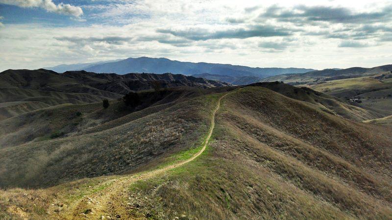
Mountain Biking Chino Hills State Park
#140 of 1,015 mountain bike trails in California
Carbon Canyon Regional Park is located in Brea, Ca and was opened in 1975 after it was determined that the area should be preserved primarily for flood control purposes. I'm not able to confirm it, but the name probably came from the abundance of oil found in the area years ago. You can even still see a few remaining oil rigs dotting the hill sides. The mountain biking isn't in Carbon Canyon but in Chino Hills State Park that is adjacent to it, but for easy parking and access just enter through Carbon Canyon and pay the $2.00 toll M-F and a bit more on the weekend. To get to the trailhead , you head east along the Carbon Canyon Rd. until you see the signs that take you around a small gate and to the trailhead below.
First added by lamirada777 on Mar 23, 2011. Last updated Oct 26, 2020. → add an update
Before you go
- Drinking water: unknown
- Lift service: no
- Night riding: unknown
- Pump track: no
- Restrooms: unknown
- Fat bike grooming: unknown
- E-bikes allowed: unknown
- Fee required: unknown
This trail information is user-generated. Help improve this information by suggesting a correction.
Take the 57 Fwy to Lambert Rd. Head East on Lambert Rd. until it turns into Carbon Canyon Rd. (142). The entrance to Carbon Canyon Park is on the right-hand side, (approx. 3 mi. East of the 57 Fwy). There is parking inside the park for a few bucks. Ride your bike to the east-most end of the park. At the end of the parking lot, there is a dirt trail that initially runs along Lambert until you get to a gate. Go around the gate and continue riding until you get to a second gate. You are now at a point where the trail splits 2 ways. Continuing straight would take you to Telegraph Canyon. Turning left takes you up North Ridge. Thomas Guide page 709 & 710 Also see Chino Hills State Park in Orange & San Bernardino County
System trails (1)


Nice long open hills that have no steep grades however they can be long uphills or maybe it was the heat that made hem feel long which is probably more true
| ThankRode Alyso Lower Canyon to Sidewinder to Bane Canyon. Long flat fire road, tough climb on narrow single track and fun downhills with some rock gardens. Trails have been recently cleared back and maintained. Nice job rangers!!
| ThankClimb Sidewinder and down Bane Canyon. Climb is lung busting with narrow single track up the hill. Downhills are pretty steep and some minor rocks. Trail has been recently reconditioned and cleared. Pretty awesome ride.
| ThankCHSP is a nice place to ride if you are looking to put some miles in without heading to the mountains. It does take some level of fitness to truly enjoy the park as the Chino Hills side entrance is closed until late Spring 2015. The fun single tracks are mostly on the eastern end of the park from 4 corners or past it. Going west on South Ridge is a very fun, not too technical, high speed rolling hill descent. There are some difficult climbs here going back west from the Rolling M Ranch on either Telegraph Canyon or Southridge. They are not technical, but are a prolonged high grade climbs at times.
| ThankGood climbs and single tracks. Lots to choose from. Definitely a good place to ride.
| ThankProbably the most underrated park in SoCal. This is probably because most riders don't know that there is much more than just Telegraph Canyon. The best trails are actually on the East Side of the park accessed by taking Raptor down towards the Ranger Station. There are also some really good climbs.
| ThankA great mid-week work out ride. The climb is a bit less than 5 miles at a mild grade with a few false peaks to make it seem like more of a work out. Panoramic views at the top from Gilman Peak is the payoff. The way down is mostly fire road and double track but can be a bit of a ripfest fun.
| ThankN Ridge is in great shape. Climbed it taking a side trip up Gilman Peak (1200') then back down continuing on until the trail ends at the No Trespassing Gate high above Four Corners. Returned back
| Thankdown N Ridge the way I came surprising a couple of coyotes.
This trail was alright, it's a very beautiful area that's only tainted once in a while with a few large electricity units hanging and buzzing above.
So far, I've only ridden down the Telegraph Canyon area, but there's a lot more to explore... the place is huge.
The maps are detailed (I can scan one in if requested) and getting lost is pretty hard, so if you're determined to get lost prepare for one hell of a challenge... this park will end up spitting you out right back at your car. :D
Anyway, great place to go, very quiet, but I don't recommend going alone like I did... just a word of advice. :)
| Thank