×

|
Rate it:
Tags:
Level: Advanced
Length: 4 mi (6.4 km)
Surface: Singletrack
Configuration: Network
Elevation: +239/ -233 ft
Total: 6 riders
Mountain Biking Zapata Falls
#843 of 1,429 mountain bike trails in Colorado
This is a series of four stacked loops. They are all fairly easy, but very bumpy with plenty of small, mostly loose rocks. There are maps at most intersections, but some of them are faded and not always legible.
First added by John Fisch on May 6, 2012. Last updated Apr 28, 2020. → add an update
Before you go
- Drinking water: unknown
- Lift service: unknown
- Night riding: unknown
- Pump track: unknown
- Restrooms: unknown
- Fat bike grooming: unknown
- E-bikes allowed: unknown
- Fee required: unknown
This trail information is user-generated. Help improve this information by suggesting a correction.
From Alamosa, take 160 east until the intersection to 150 heading north to the Sand Dunes National Monument. 10.7 miles north (about 3 miles before the Monument) there will be a dirt road heading east toward the Sangre De Christo Mountians. There shoudl be a sign indicating the road to Zapata Falls. Follow this road about 3.5 miles to a large parking area. There are numerous trailheads on the downhill side of the road linking to the loops.


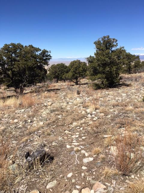

The road isn't maintained very well, so I figured the trails wouldn't be either. The trails are not maintained. I counted 3 downed trees that blocked the trail. It's basically fallen apart. The trail signs are difficult to read at best and navigation is a chore. It's quite rocky and no real flow can be attained.
| ThankI would only ride this trial if you were in the area and didnt have the time to get to another one. The road going up the mountain is fairly rough. Once up there the trail heads are fairly easy to find. However, the trail can be fairly hard to follow with most of it looking like wash outs. There are lots of maps on the trial, but getting to each one can be a challenge and really kills any flow while you try to figure out if you are still on the trail.
| ThankCould have been a fun ride, but the road going in was not really worth the effort. Like another reviewer said, if you are going there to camp or hike would be worth riding...maybe. Trail is mostly comprised of small rocks and semi-washes. Would be good for someone just beginning to get into intermediate riding...maybe! Be sure and be navigationally aware, the signage is only semi-helpful.
| ThankThis is definitley not a place to go out of your way to hit. From the parking area, your option is to hike the foot only trail to the actual falls which are tucked away in a narrow slot canyon and you actually have to wade through the icy creek to get to the falls. As for the trail network open to bikes, it's not much of a ride, or even worth hiking. You don't even get much of the great scenery you find in other options in the immediate area. The lack of interest is reflected in how the trail completely fades out in places. If you're here to see the falls and have a bike along, it may be worth pulling it off the rack; otherwise, this one is a pass.
| Thank