×

|
Rate it:
Tags:
Level: Intermediate
Length: 8 mi (12.9 km)
Surface: Singletrack
Configuration: Loop
Elevation: +2,131/ -354 ft
Total: 141 riders
Mountain Biking White Ridge Bike Trails
#14 of 284 mountain bike trails in New Mexico
Tucked away in rugged and scenic country southwest of the community of San Ysidro, New Mexico, is the White Ridge Bike Trails Area. Just to the west is the newly designated Ojito Wilderness. Both sites are a short distance from U.S. 550. This region is known for its geological, cultural and paleontological resources, as well as for its scenic qualities. The bike trail crosses a landscape of spectacular beauty and exceptional geology, meandering through the Pueblo of Zia, State of New Mexico, and public land managed by the Bureau of Land Management (BLM). BLM has obtained rights-of-way from the Pueblo and the State to provide this biking experience. Although the Trails have been developed primarily for mountain biking, hikers are welcome on the entire trail system, and one segment is also open to equestrian use.
First added by jlampki on May 25, 2009. Last updated May 1, 2020. → add an update
Before you go
- Drinking water: unknown
- Lift service: unknown
- Night riding: unknown
- Pump track: unknown
- Restrooms: unknown
- Fat bike grooming: unknown
- E-bikes allowed: unknown
- Fee required: unknown
This trail information is user-generated. Help improve this information by suggesting a correction.
Traveling northwest toward Cuba on US 550 from Bernalillo, the drive is approximately 20 miles. Before San Ysidro (about two miles), turn left onto Cabezon Road (County Road 906) at the intersection of Cabezon Road and US 550. Follow the left fork. Travel 4.4 miles to the gravel parking lot.


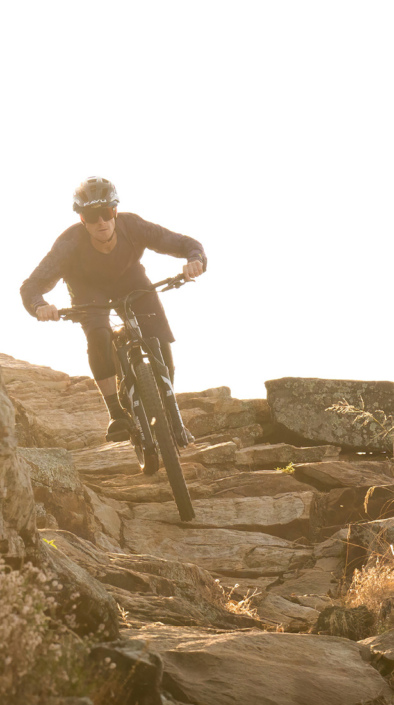
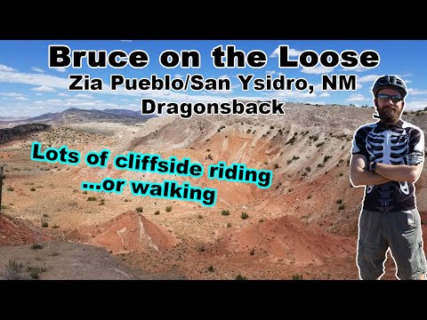
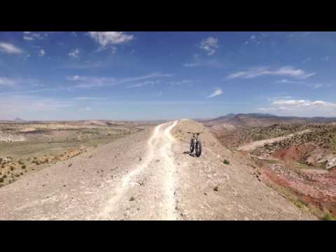


The views are enough to ride here. From the trailhead I rode a clockwise loop that took me 8.9 miles around the ridge. The was a lot of varied terrain. I would caution that the Dragon's Back is advanced, more so with what would happen if you went down. If you are in the Albuquerque area this is a must ride trail.
| ThankGreat trails just need more of them.
| ThankGreat defined trails, AMAZING views
| ThankMaybe we picked the wrong direction or trail, but this trail system presents like an advanced trail, not intermediate. This trail has some serious exposure with offshoots that can jettison you off a 200 ft cliff.
After a fun climb from the parking lot, we picked the middle ridge to start. It started with a steep flowy downhill, but were quickly faced with deteriorated trail conditions that dropped significantly to unsafe, barely hikeable trails. Against our better judgement, we began to hike-a-bike down, but quickly realized the trails were not safe to continue. We climbed back to the top where a local guided us clockwise around the west ridge. The exposure was unsettling, so we decided to opt for a trip to gallup which is more intermediate friendly.
Pros: The views are absolutely amazing. The beginning and west ridge are an absolute blast. Locals are super friendly and awesome.
Cons: exposure, deteriorated (middle) trails, unclear side paths of trails that can lead to dangerous results if you aren't familiar with the trail
| ThankGreat setting for scenery and exposure but I found the tread to be marginal. Bumpy and pockmarked with areas of deep erosion and numerous cut arounds. Signage was good but several signs were missing. Nice spring area on the east side but I wasn't thrilled about riding through it. Definitely worth riding regularly but I would caution against riding with a stiff crosswind!
| ThankA fair amount of climbing for the loop. Great vistas.
| ThankFast, flowy singletrack. A little climbing but nothing technical. Beautiful views all around.
| ThankNothing less than awesome.
| ThankThis is BEST ridden clockwise. Follow the numbers on the map. Desert fun.
| ThankReally fun ride. I'm glad I drove out there. I rode clockwise following the number system. Very well marked and the ridge was a blast. The only con is the 4 miles of heavy washboard road to get to the trail. But it's worth it.
| ThankThis trail was awesome: fun,fast,and high pucker factor.
| ThankBeautiful & fast
| ThankAn Amazing Trail. Tucked away and very off the beaten path. You will have to make a deliberate trip to make this trail. It is worth it! A great trail with plenty of flow, climbs, fast descents and hair raising edge of the world riding. Great Trail!
| ThankAmazing views, fun flowing single track. Well marked.
| ThankThis trail is 5 stars for its setting, but I would consider the riding 4 stars. You can pick your lines in some areas, which opens up some fun free-riding. Trails could use better marking as choosing direction on trails impacts the ride quality. Unique adventure any true MTB should experience.
| Thankthe track actually on the mesa is awesome but don't go try the hike a bike. its not well marked and in some places the trail isn't there anymore. the actual trail on top of the mesa is the part Im rating
| ThankLOVED THIS TRAIL! HIGHLY RECOMMENDED!!!!
| ThankNot knowing where to ride I used the reviews here to get me started. The trail is narrow but very managible. Familiarity will really enhance your ride since there are a lot of areas to pick up speed if you know what lies ahead. I rode the dragon spine clockwise. Hiked my bike up the ledge and completed the circle as it is numbered. Towards the end there is a peak that looks like it has a ton of traffic. Almost bike park look to it. Will definitely go back again.
| ThankThe road to get to the TH is really rough, but doable. Fantastic views! It is pretty well marked with maps telling you where you are. Some advanced trails with alternate routes. Great ride!
| ThankAmazing scenery, and a great ride.
| Thank