×

|
Rate it:
Tags:
Level: Advanced
Length: 32 mi (51.5 km)
Surface: Singletrack
Configuration: Network
Elevation: -
Total: 31 riders
Mountain Biking Rim Trail
#39 of 287 mountain bike trails in New Mexico
Great trail full of long climbs, long descents and challenging switchbacks. There is 32 miles of trail to work with that parrallels the road leading to Sunspot, an observatory. The trail does require a certain level of aerobic fitness and high altitude conditioning. I've seen some of my strongest amigos push their bikes up the climbs (including myself) SCF
First added by searsandrewj on Jan 1, 2003. Last updated Apr 30, 2020. → add an update
Before you go
- Drinking water: unknown
- Lift service: unknown
- Night riding: unknown
- Pump track: unknown
- Restrooms: unknown
- Fat bike grooming: unknown
- E-bikes allowed: unknown
- Fee required: unknown
This trail information is user-generated. Help improve this information by suggesting a correction.
From Alamogordo take 82 to cloudcroft (15 miles) then right onto Sunspot Hwy. Turn on 6563 and a 1/2 mile on the right will be a good place to park , trail map, and picnic area.


Is this a OTV trail also
| ThankIs this a OTV trail also
| ThankThis route had me squealin from the feelin on some rocky climbs, but the views and solitude out there made up for the pain. Great time on the trail, a few trees down right now, but nothing you can't handle by jumping off the bike and hopping over. Went back into town and had Mad Jacks for lunch before I took off, highly recommend! I'll be back that's for sure.
| ThankI ride a Breezer Storm 29er Expert
Very fun trail. Not joking about the conditioning. Some climbs were more harsh than others. Some rocky downhills, but I managed well with my hardtail. Beautiful views in certain spots. All in all, a very fun trail to go out and ride. Feels isolated in many places when in reality, it's close to the town. Makes for a fun, great ride.
| ThankWhile visiting my folks last week I had my Dad take me out to the far southern TH and rode the whole trail all the way back to Cloudcroft.
Here's my Strava link in case anyone wants the map of that:
https://www.strava.com/activities/304699593
Southern end is no fun to ride at all. Its an old road covered in rocks that climbs straight up and down a series of higher ridges. No switchbacks, no flow, hike-a-bike uphill and rock surf downhill. Does have the best views and a remote feeling, but I can't recommend that anyone should ever go expect a fun ride on that end. Took me three hours to get through that first 11 miles.
Trail slowly gets better as you get closer to Cloudcroft. The section near Sunspot Observatory had some grassy meadows and at least contained more actual singletrack. Still an extremely loose and rocky section for the most part. I was riding my 6" trail bike Yeti SB-66C and that is the main reason the downhills were still pretty fun. I would have hated it on my cross country bike.... just too loose and rocky to ride fast (for me at least) on a bike like that. At least I could plow through that stuff on my Yeti.
Final 8-ish miles to Cloudcroft are really fun trail! I was pretty worked and could not enjoy it quite as much as I wanted, but I would love to go back and ride this part fresh. Trail was MUCH more flowy and fun in this section. Still rocky in places but nothing like the constant rock-surfing battle of the miles before.
So I do highly recommend the Northern End. My 4-star rating is for North only. Only ride the southern end if you hate yourself.
Entire trail took 7 hours 15 minutes with 6800' climbing over 31 miles.
| ThankIts an easy and mostly clear trail. The reason for my intermediate rating is because there are lots of section to carry a lot of speed. Be careful, there are numerous areas with loose sharp rocks between golf ball and baseball sized for the first few miles. The further you go into the trail the better it gets in my option. I even seen several turkeys at one point. Also be aware that you will have to turn around at some point and the hills will seem much longer on the way back.
| ThankNorthern part is all in the trees hidden from all but the deer and elk. Expect cool conditions even much of summer in the deep shade, forget the sunscreen but prepare for the many roots. It's not singletrack, ATV cut trail right thru the heart of the forest. Trail is much too rough for a flowy ride.
| ThankThis review is for the stretch of T105 (Rim Trail) from Sunspot to the slide area (shortly before Highway 130 intersects 6563).
This trail is very rocky. Most of the time the rocks are embedded in the ground, but there are several sections where loose baseball-sized rocks cover the trail. It seemed to me that this was most true of the climbing sections, but maybe that was just because I was tired.
Speaking of which, it's been mentioned before by other reviewers, but I'm going to hit the point home again: this trail is at very high elevation (8,350 - 9,500 feet). You WILL get winded easily if you're not conditioned, which makes the climbs much more difficult.
There really are no steep climbs (that I saw), but it felt like they were. I had to stop several times to catch my breath when I first rode it.
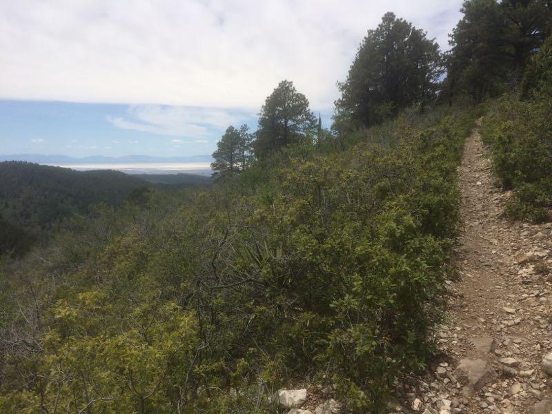
You'd think that with a name like "Rim Trail" you'd get non-stop awesome views from the top of the mountain. Not so. Most of the time you will be riding in a wall of trees and won't be able to see very much. There were a few sections closer to Highway 130 where you could get a glimpse of the Tularosa Basin, but that's about it. I did see some elk on the trail though, so that was cool.
Great trail. Excellent signage. A little on the rocky side for my tastes (I ride a hardtail...Lightweight XC Full suspension ride would be the way to go if you have it!). Basically an out-and back. Ride as long as you can and turn back when you need to. The trail also parallels 6563, so if you're not feeling riding back on the same trail you just rode, hop onto the highway and pedal back.
| ThankRim trail is awesome , nice views and some decent downhill sections..start at the top off mile marker 6 right past take a right and follow to head of trail on right.* Review edited 9/2/2008* Review edited 9/27/2008
| ThankAwesome trail. Can call it quits at many spots or ride for close to 20 miles. Can see deer and elk while ridinig thru high country pines. Take the easy way back down the highway straight to the old west style bar in Cloudcroft for a celebratory brew.
| Thank