×

|
Rate it:
Tags:
Level: Beginner
Length: 6 mi (9.7 km)
Surface: Singletrack
Configuration: Network
Elevation: -
Total: 28 riders
Mountain Biking Rich Park
#253 of 554 mountain bike trails in North Carolina
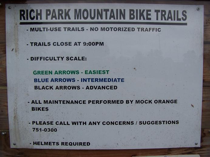
Enter trail 2 at kiosk marked with IMBA signs. Follow signs to blue trail across the bridge at bottom of hill. The blue trail is intermediate and 1 mile long. Next is the beginner section that is 1.75 miles long, flows well. After you come out of the begginer trail , go left into the gravel parking lot and where the driveway comes into the gravel, directly behind that is the trail head...some logs help guide you in. It's not marked..but be ready!! Next is the black diamond, and it is a lung buster. This is not for any beginners, this is serious up and downs, and is tough, trail is 3.2 miles.Take your pick of the 3 trails, but I start with blue, green and then black.
First added by searsandrewj on Nov 9, 2004. Last updated Apr 30, 2020. → add an update
Before you go
- Drinking water: unknown
- Lift service: unknown
- Night riding: unknown
- Pump track: unknown
- Restrooms: unknown
- Fat bike grooming: unknown
- E-bikes allowed: unknown
- Fee required: unknown
This trail information is user-generated. Help improve this information by suggesting a correction.
40 west towards statesville, get off on the Farmington Road exit and take a left over the bridge...at the stopsign merge right onto 158 I believe is what it's called. Go towards Mocksville, once you get into mocksville where the big houses on on both sides of the st. Look on your right and there are 2 signs to get to Rich Park about a block...to a block and half apart from each other. Good Luck


Unmaintained. Don't waste your time or gas. Couldn't find any trails.
| ThankOnce upon a time, these were probably pretty fun trails, but they are not being maintained and have become almost untraceable. What little signage there is is confusing. Such a shame.....
| ThankI have tried to ride this trail several times, and I never could find the whole trail. It just kinda disppears into a field at one point. I rode this trail fully with my Dad when I was like, twelve, but I'm 18 now and still can't find the whole trail. On kind-of a side note, I rode down that climb classed as "black-Diamond". Would the class change going down, or remain the same as going up?
| ThankWent over the weekend because it's local. My wife wants to try mountain biking, so I figured this would be a good place because of the beginner trail. Never found that one though, only the intermediate trail which was a bit too much for her.
| ThankThese trails are horrible! The trail heads are marked but thats about it. Trails need to be remarked.
| ThankThis is a poorly(if at all) maintained trail. It is a complete waste of time. Seemed like the park wanted a quick fix to get in on the MTB cyclists.
| ThankI started with the blue (intermediate) course and was a bit confused as to where the trail was going. No directions for a trail head and after some riding I seemed to get on track. I just rode the blue trail until I found the freeride section! Wow! Tight and technical, it needs some clearing but some fun drops and berms with cool bridge crossings over creeks! Very nice, just needs some clearing. Beginners beware as I am one....this trail will kick your ass but you'll keep coming back for more!
If anyone involved with Rich Park Trail maintenance reads this-- I would love to volunteer to help clear and fix some broken drops on the freeride trail.
| ThankKUDOS!!! I returned after reading that there had been work done....and it is great!! Many, many thanks to those folks who did that, it is a total "180" turn-around. Great markings, good flow, clean, the "difficult" trail is GREAT (what I saw of it, had to walk out after about 1.3 miles due to broken spokes) but did do both other trails, very very good now. Thanks again to all that worked on it.
| ThankWe, the Davie County Cycling Assoc. are in the process of revamping the Rich Park trials. Our goal is to make it as fun and user friendly as possible.
The Beginner and intermediate trails are all but completed (Pending some minor tweaks)and very ridable, flowing nicely.
The Advanced trail is getting some much needed attention. We are in process of "Bench Cutting" a lot of the side hills and adding some more user friendly lines. It will still be an Advanced trial with a lot of climbing and technical aspects. 95% of the Free-ride section is still intact and functional (w/ Go rounds on everything). We hope to have the trail fully ridable very soon, w/ constant improvements through out the year, including new bridges, additional loops, and better sign-age.
Please come out and give the "New" Rich Park trails a shot.
If your interested in volunteering for trail building, please contact the Davie County Cycling Assoc. http://www.daviecycling.com/dnn/Home/tabid/475/Default.aspx
| ThankHey i just got back from riding rich park today and it was so confusing. It took me a hour to find the right trail and then i spent like a hour on it trying to find the advanced trail. So i finally found the advanced trail when you are in the gravel parking lot go back to where the gravel and pavement meet and look towards the woods their is a pile of logs and brush go in their. The trail will fork you go right and then it is just over grown so so much from their until you get down the hill. After all that once you get paset all the hills and u get towards the back i spent like a hour and a half looking for the north shore stuff that another guy said their would be. All i found was a bunch of singletrack, over grown stuff, 4 north shore drops that were still in very good shape u just got to know how to get to them one was 1, 2, 4, and 7 foot drops, a wall ride that was still in good shape, and a log bridge that was rotting. Their is a whole mess of trials back in their that who knows where they go. I went out searching for a huge north shore section with 10 foot drops and wall rides and skinnys like the other guy said but did not find them. Mock Orange Bikes needs to go do some trail mantenice and if they did this would be a really great trial.
| ThankThis was one of my worst experiences with trying a new trail. I found one trail only because the entrance is directly behind the sign (as in the description). It is a VERY short trail. other than that, I could not find any other actual trails. I rode around the entire park, nothing. I rode on the one marked "nature trail", VERY EXTREMELY short, not even worth calling it a trail, I hope it is not one of the actual trails. NOTHING was marked, the one time I thought I saw markings (some orange "tape" around the base of a tree at a "trailhead") at the very end of the entrance road on the other side of the ball fields, I started the trail, it forked, I go right, so overgrown there was practically no trail. To the left, the trail ended in 50 yards. If someone wants to send me a message maybe enlightening me on something maybe I missed, I may give them another try, but until then I think I will pass on these next time.* Review edited 7/17/2008
| ThankThe trails need to be marked. I had a tough time finding the trailhead for the intermediate or beginner trail (I couldn't tell). I never did find the advanced trail although it sounds fun. It would be unfair for me to rate my trip because I didn't find everything it had to offer. Perhaps the guys at Mock Orange Bike could post a map on thier website.
| Thankthe trails are fun and fast need more trail markers for all the trail fun enough i will be there more this summer to ride keep up the good work
| ThankOK..The first trip we took here was a disaster b/c the first two trails are very easy and somewhere at the end of the intermediate trail we kept ending at the same spot with nowhere to go, I say there were alot of leaves then and could have been covering up the trail end. We never found the "black diamond, lung buster"....WELL...let me tell, after further review I found it today and it's no joke, very hilly...ton of short and fast climbs, with a ton of long steady climbs, technical with a lot of logs rides, steep drops ins, some short and some long with long really high decent thats very steep, a few creek rides...for the trail to only be 3 miles or so...it will wear your butt out. Not for the weak hearted and I would highly recommend it to freeriders, and extreme cross country riders. Will I ride it again, you bet, only gonna make you better!!
| Thank