×

|
Rate it:
Tags:
Level: Intermediate
Length: 12 mi (19.3 km)
Surface: Singletrack
Configuration: Network
Elevation: +327/ -312 ft
Total: 21 riders
Mountain Biking Pine Nut
#23 of 126 mountain bike trails in Nevada
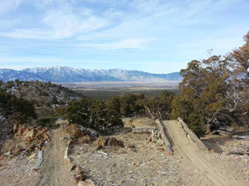
From the parking area cross the road and head off on the single track . There is an endless network of trails here , try to stick to the singletrack with the bicycle tracks . Lots of fun ups and downs no huge climbs great views of the Carson Range, lots of moto guys . I think these trails might be hot and dusty on the summer but are great spring riding .
First added by Valerie on Feb 18, 2007. Last updated May 4, 2020. → add an update
Before you go
- Drinking water: unknown
- Lift service: unknown
- Night riding: unknown
- Pump track: unknown
- Restrooms: unknown
- Fat bike grooming: unknown
- E-bikes allowed: unknown
- Fee required: unknown
This trail information is user-generated. Help improve this information by suggesting a correction.
From 395 South of Gardnerville turn East on Pine Nut Road across from the 7-11 . Head East @ 3 miles - look for Pine Nut Road to turn left - if you continue straight and get to the dump turn around . Go on Pine Nut Road @1 mile look for a parking area on your right with a trail map kiosk . Park there


So this section of trails has been built by people at the beginning of the century (2000s) and has since been abandoned. They were built by pro downhillers and they practiced on them. As Charging_Rhinos states in a review below, there was a race called the Pinenut Cracker, but they stopped putting it on in 2011. Charging_Rhinos has the best directions, however, the date from his review is over 10 years ago. Here is how you get there, there is a trail head for pinon trail, that's not it. There is the lot with the lone tree on the right just down from the pinon trail head, also not it. There is an offshoot not very far before the parking lot, turn down that road.I say road, it's more like 4x4 trail. It is kinda bumpy. A truck or SUV will probably be needed if you aren't gonna ride it. Continue down and there will be a fork, TAKE A LEFT. Not far down that and there is an area to the right that you can't really tell is anything but is the end of a trail system. There is some weird jump parts, a bike stand, and you will see some jumps if you go in far enough. Park there. If you keep going up that road you can get to the top, however the jumps and trail are in very sketchy condition and personally I can't send that huge. So we just walk up from the bottom and you will find a small jump line and it is pretty good. It is very hard to describe in text, and I cannot put pictures in. If you want to send this, message me and I can give you pictures with better directions. Pictures talk way better than text.
| ThankThe trail is hard to find and i didn't find it so i just rode the dirt bike carved trails thru the pinions. Keep going farther east to reach the trail.
| ThankSingle track in the beginning but changes fairly quickly to ATV/recreational vehicle trails. My ride was during fall and much of the trail was sandy. Lots of rolling track and fun track if you can get through the sand. Circling back from the west takes you to a fun area of trails with lots of up and downhill but can be easily avoided if preferred. Easy access to trails from the paved road. Good area if biking alone - with little exposure and good views.* Review edited 10/28/2008
| ThankI grew up at the base of these mts, and rode there every day for 13 years. The riding here is EXCELLENT, and the trails are completely endless. They're not well marked like in Utah/Colorado, so it's a bit more 'adventurey.' I'd recommend a topo map to avoid getting lost, but be smart and you'll have a great time.
Best times to ride are in late spring/early summer and fall. Mid-summer gets really dry, hot, and dusty. Please don't ride during/immediately after rain, as it does mess up the trails badly, and you'll more than likely get stranded in the clay-like mud that forms.
Directions: Go east up Pinenut Rd from the 7-11/Hwy 395 intersection for a number of miles (watch for cops here) until you get to the fairgrounds. Turn onto the road that parallels on the left, and go east a few more miles on the c***py pavement into foothills. Park at the large pull-off on the right by a lone Pinion pine tree (easy to recognize). There might be a kiosk here, but it gets torn down every once in a while by the more 'territorial' locals. Mount up, ride south, and enjoy. The main road that goes south ends in a very steep drop into a ravine called 'Suicide.' Back up a few hundred yards and you're at a great place called the Playground. The best riding is in this immediate area and east into the mountains. There's a race every year in this area called the Pinenut Cracker. Way fun!
As mentioned before, there are a lot of mx bikes and 4-wheelers in the area. They're out to have fun just like you, so don't hate them for being out there too. Just listen for them and remember that the right-of-way tends to lean to whoever has more speed (unspoken Nevada protocol)* Review edited 6/25/2008
| Thankwell there are a ton of trails up there but no kiosk to tell you where the trail starts te only real way to find it is by exploring. there are alot of ups and downs and all in alll a good time
| Thank