×

|
Rate it:
Tags:
Level:
Length: 15 mi (24.1 km)
Surface: Singletrack
Configuration: Out & Back
Elevation: +700/ -892 ft
Total: 17 riders
Mountain Biking North Yuba
#283 of 1,015 mountain bike trails in California
Nice rolling trail for 7.5 miles we did first a beginners but we would try anything. a lot of shale nice views of river. Maps are at Yuba Expedition in town. Good pizza shop and food in town.
First added by Juan_Gear on Jun 16, 2005. Last updated Apr 30, 2020. → add an update
Before you go
- Drinking water: unknown
- Lift service: unknown
- Night riding: unknown
- Pump track: unknown
- Restrooms: unknown
- Fat bike grooming: unknown
- E-bikes allowed: unknown
- Fee required: unknown
This trail information is user-generated. Help improve this information by suggesting a correction.
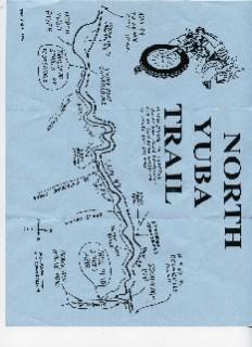
Hwy 49 to Downieville Park at Rocky rest Camp Ground across bridge to trail
System trails (1)

Your right NA of Co. I'm E-litrate . This one is weak
| Thank