×

|
Rate it:
Tags:
Level: Intermediate
Length: 14 mi (22.5 km)
Surface: Singletrack
Configuration: Out & Back
Elevation: +492/ -434 ft
Total: 24 riders
Mountain Biking North Shore Trail
#74 of 321 mountain bike trails in Oregon
This is an out and back that follows the shore and the road. There are several outs from this if you want to turn back and ride the road. The trail is a nice tacky trail that winds thru old growth trees. Some small steep climbs, but very easy. Several creeks filter down to the reservoir and some will need to be stepped across. There is one point a bit after the picnic tables that seems like the end. Just turn around and there is a trail up to the road. Ride down the road for maybe a 1/4 of a mile and the trail starts up again on the left. The trailheads are marked by a sign with hikers on them. Some downed trees throughout which have built in ride overs. The trails out ends at another boat ramp. Be advised the PCT is near the ramp which is a non-bike trail. Turn around and ride back.
First added by Sierradirtslayer on Jun 16, 2010. Last updated May 9, 2020. → add an update
Before you go
- Drinking water: unknown
- Lift service: unknown
- Night riding: unknown
- Pump track: unknown
- Restrooms: unknown
- Fat bike grooming: unknown
- E-bikes allowed: unknown
- Fee required: unknown
This trail information is user-generated. Help improve this information by suggesting a correction.
From Eugene go East on 58 for about 20 miles. Make a left at the covered bridge and continue to N. Shore Dr. Turn Right, this will become N. Boundry Rd. Continue till you come to the damn. There will be a parking lot with a bathroom by the boat ramp on your right. Trail head is on the left side, marked with a Hikers sign.


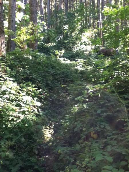

I think this trail could be awesome, unfortunately I rode it in the early summer vegetation growth boom. Once the vegetation (thorns, nettles) are cleared from the trail then this will definitely be great for all types of riders. There's pretty views as it runs along the lake and the typical fresh Oregon forest scents. I hope to come back some day and ride this when the vegetation is cleared.
| ThankIt was fun but the first half is blackberry briars really tore up my legs. If you go past the hocking trail marker on the road you skip them and get straight to the fun.
| ThankConditions on this trail have change recently. Extensive work has been done to improve riding conditions on some of the degraded sections. Also, much brush has been cut back, so poison oak is not so much of a concern. I rode it about 2 weeks ago, and although it was a little muddy, it was a great ride. I barely touched any bushes, and the wettest parts are well-gravelled now. There are some challenging technical parts for intermediate riders--mostly at water crossings. Two notes: 1) The PCT is nowhere near this trail, and 2) the trail resumes on the right side of the road not the left if you're headed east from the dam. Also, check out the connecter trails that lead to higher elevation trails with TH's in Westfir. Get recent topo map of Oakridge area trails. Great workout--great ride!
| ThankI tried to run this trail today. I only got about a mile before turning around due to nasty blackberry ivy and poison oak. Might by passable on a bike. I live close though and am going to try to get some maintenance done soon.
| ThankThis is a really fun trail to ride. I enjoy this type of trail where you can flow through the trees. The only bummer is pretty much every time I've ridden it I've come down with poison oak.
| ThankFun flowy singletrack. Closest trail to Eugene according to Collins Cyclery. I guess they don't have much mtn bike trails in Eugene. Very wet when I rode it. Would be nice once dry. Lots of water flowing in various places. If clear could rip thru this trail. Very green and lush, some tables midway that you can stop and take a break on.
| Thank