×

|
Rate it:
Tags:
Level: Beginner
Length: 3 mi (4.8 km)
Surface: Singletrack
Configuration: Network
Elevation: +33/ -58 ft
Total: 50 riders
Mountain Biking Jackson Bluff Trail System
#26 of 116 mountain bike trails in South Carolina
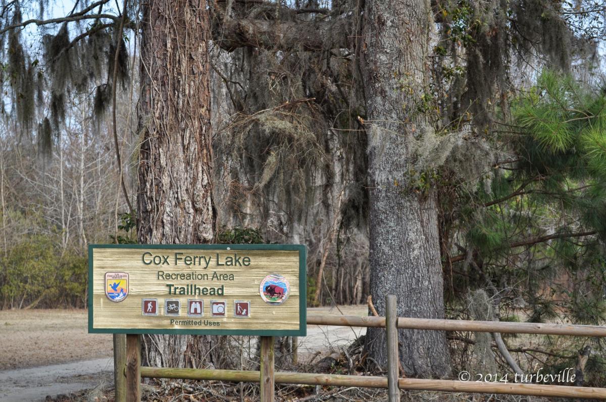
Great new trail on the Waccamaw National Wildlife Refuge. Trail ends up at the
Cox Ferry Recreation Area with a covered picnic and kayak launch area. It has a
combination of singletrack, doubletrack, and fire road. The singletrack trail, just
built with the help of IMBA, is technical and demands your attention and focus.
Doubletrack and fire road is fast and smooth. Beautiful new wooden bridge on
the main trail. Riding the trail from the trailhead to the recreation area and back
will get you a 6.2 mile ride. Trails are marked with Blue, Yellow, Orange, and
Green diamonds. Visit the website at http://www.waccamawtrailblazers.com/.
First added by gtc88 on Aug 6, 2010. Last updated May 11, 2020. → add an update
Before you go
- Drinking water: unknown
- Lift service: unknown
- Night riding: unknown
- Pump track: unknown
- Restrooms: unknown
- Fat bike grooming: unknown
- E-bikes allowed: unknown
- Fee required: unknown
This trail information is user-generated. Help improve this information by suggesting a correction.
From Conway on Highway 501:
Take Highway 544 South 1.6 miles toward Surfside Beach. Turn right on
Jackson Bluff Road at Gullies Shell gas station. Drive past Grand Strand Water
and Sewer. Continue straight past the water retention ponds on the left. You
will see a sign that reads " End of State Road Maintenance." Drive straight and
the pavement will begin to get a little rough. Go past the creek and look for the
trailhead entrance and parking area on the left.
From Surfside Beach 544 Exit off of 17 Bypass :
Take Highway 544 North 10 miles toward Conway. Turn left on Jackson Bluff
Road at the Gullies Shell gas station. Drive past Grand Strand Water and Sewer.
Continue straight past the water retention ponds on the left. You will see a sign
that reads " End of State Road Maintenance." Drive straight and the pavement
will begin to get a little rough. Go past the creek and look for the trailhead
entrance and parking area on the left.


Was in the area for my birthday weekend of April 22 & rode this park. Loved it as I am attracted to wooded trails near the water. Hot today but otherwise was a good ride. Boardwalk seems to be closed due to damage. Tree across on bike trail.
| ThankThe bridge through the swamp had been closed since 2015....there are @ least 3 down trees on the bike path that you have to lift your bike over to
| ThankPass....I like the trail but I wish it was maintained better
Overgrown and parts are closed since the flood.
| ThankLarge downed trees everywhere. Boardwalk is closed. Bike trail is less than a mile long. And the gps directions put you in front of somebody's house a couple miles down the road....but I can say I've been here now
| ThankThe boardwalk is closed and has been since 2015
| ThankDecent, but very short
| ThankSo I hit this trail system earlier today. Last weekend I rode The Hulk. Until recently, it has been several years since I've hit the trails, so fitness wise, the Jackson Bluff Trail is ideal. Fun wise, I'll take The Hulk any day. This trail system (JBTS) is closer to my house and until I'm in better shape, I'm sure I'll be hitting these trails often.
| ThankToday, the trails were mostly dry, but covered in leaves (leaves in fall, go figure). This caused some issues with me staying on course. The fact it was my first time out there, had a lot to do with it too. So I know as I get familiar with it, staying on course won't be so difficult.
From a newcomers perspective the system is a great place to learn and grow into the sport. With the established log roads and improved trails, there's plenty of good trails for someone like me just starting out. There's just the right amount of uphill & downhill grades to make a circuit around a decent workout & a thrill. But add to that, the single trails that are available have plenty of challenge as well. I've only tried my hand at just a few of the easier singles, but have seen enough to know that there are some real "hairballs" to contend with. I might never muster the courage to try some of the drops & switchbacks, out in the thick of the woods, but that's not going to keep me from trying in time.
| ThankI like this trail system. The single track provides some challenges and if you want too speed it up run the double tracks and fire roads. Everything was well marked, no issues navigating. After a couple runs through the trails it is easy to put together you own routes to mix things up.
| ThankEasy trail for a light ride. Beautiful scenery. If you take the blue trail, it can be rough. Lots of roots in trail where turns are narrow and tight
| ThankNot a bad little trail system in a unique area. The bike trail was leaf covered and we had a little trouble staying on course where some of the other trails intersect. Nothing too technical here but the little pond area, boardwalk, and boat launch were interesting. A good place for a short ride.
| ThankFun little trail in the woods for a change of pace from beach paved trails. Thanks for the good map and keeping it up
| ThankNice clean fun trail! Very peaceful!
| ThankThe trails right now are about 2.70 miles of pure single track. After the big gully what i like to do is turn around and come back to the entrance. They are a lot of fun and currently the Waccamaw Trail Blazers are currently building more trails.
| ThankDecent mix if technical turns and grade to open trail. The network of trail options means you can ride for a few hours and keep changing the trail you ultimately ride. Wound up covering 6 miles the first ride after looping and randomly choosing directions.
May not win Fame, but certainly a fun ride and a good learning experience for newer riders or someone looking to add some more flavor to their own trail experience.
| ThankWe rode this trail while vacationing in Surfside Beach. The existing single track is in great condition and it was a pleasure to ride. I see a lot of potential to increase the amount of single track. We really enjoyed the gully. * Review edited 4/29/2011
| ThankFun Trail while on vacation. Really great because trails at home had up to a foot of snow in February.
| Thankits a fun trail for a beach town
| ThankThese trails are awesome. For the 1.2 mile singletrack it has. Traveling at 12 to 15 mph, it's a rollercoaster of a ride. Put down 15 miles on these trails in the last 2 rides.
| ThankFun trails outside Myrtle Beach, SC. They are creating more trails soon and it should be a lot of fun for folks in the area!
| Thank