×

|
Rate it:
Tags:
Level: Intermediate
Length: 3 mi (4.8 km)
Surface: Singletrack
Configuration: Network
Elevation: +175/ -184 ft
Total: 52 riders
Mountain Biking Ern N Burn
#35 of 288 mountain bike trails in Florida
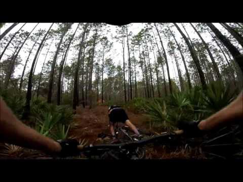
The trail is mostly on what looks like the diggings from an old barge canal. The trail is well made with plenty of bench cuts and the trail is re-enforced with shell in many areas. Because the trail takes advantage of the diggings there is plenty of quick elevation changes and nice flow.
First added by IdahoLife on Nov 27, 2011. Last updated Apr 28, 2020. → add an update
Before you go
- Drinking water: unknown
- Lift service: unknown
- Night riding: unknown
- Pump track: unknown
- Restrooms: unknown
- Fat bike grooming: unknown
- E-bikes allowed: unknown
- Fee required: unknown
This trail information is user-generated. Help improve this information by suggesting a correction.
The trail is located in the Ross Prairie section of the Santos network. To get to the Ross Prairie Trailhead take I-75 exit 350 and head west on SR 200. The address is 10660 SW Highway 200, Dunellon, FL


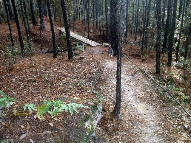

In my opinion, this is the hardest blue in the system. Lots of elevation change with rocks and wooden bridges. This is one of the best trails in the system that doesn't get the respect it deserves. Hitting this trail with Nayls makes for the best ride at Santos IMO.
| ThankFun layout. It is not a loop so you ride it one way from east to west then back the way you came. Flows better from east to west. There is a small series of pump sections with rocks and tight turns. Well maintained.
| ThankGreat trail with a quite a few dips & climbs to test rider and bike. A fair portion of trail mimics mountain trails as it follows ridge tops with 10-20' drops if one leaves the trail. Probably the most challenging blue trail in the entire OBMA system. Good combination with Nayl's trail out of 49th Avenue trail head. For a shorter trip out of Ross Prairie Trail Head take Beyond trail east and ride this trail on the return west ride home.
| ThankRode this trail with some friends and we all really enjoyed it. We came from land bridge and this was my favorite section. Some slightly technical stuff in the beginning and a quick, fun ride the rest of the way. Trail was in great shape and weather was perfect. Ross prairie trailhead was a nice place to fill up water and rest.
| ThankDid this trail at the end of the day. Woudl have been more fun if I was fresh, but it seemed very slippery with lots of pine needles and leaves on trail. Slid off at couple points. Have to manage your speed because you want to go fast and then a tight switchback pops up. Same difficulty either direction. More flowy than anything else at Santos but is at far western end of trail system. 20 minute drive from Vortex. ONe of the better trails, if not the best for pure fun rolling and riding.
| ThankAwesome trail. I started at the 49th St. Trailhead and rode the 6 miles to SR484. Came back on the "easier" trail that was about 4 miles. Nice little play area on the way back too!! Fast and flowing....my new favorite!!
| ThankThis trail is a new fantastic addition to the Ross Prarie Santos area trails. It is pure intermediate flowy fun! There are a couple technical challenges, with a giant rock crossing that was tough to clear on my xc hardtail and a weird climb on a diggings pile with a hairpin corner around a tree and some sawgrass up top. Lots of rock gardens throughout with some big limestone hunks to dodge that can set you off your line. (carbon crank killers). The trail is fairly new and still needs to be broken in, packed down, and perfected, but whoever laid it out did a fantastic job of using all the terrain available to make the most fun. You can connect this with Nayl's trail east and west and the canal diggings loop to make a great 18 -20 mile out and back (depending on starting point) from either Ross Prarie campground or the 49th street trailhead. 49th st makes it easier with Nayl's west as a warmup to Ern n Burn both ways skipping the 1.3 mile yellow trail accessing Ross Prarie campground and continuing back on the slightly easier Nayl's east/yellow to cooldown on the way back. Coming from Ross Prarie is a bit longer and leaves you on the more strenuous section of Nayl's and Ern n burn when you are a bit more tired. Both options are a lot of fun and seem like more of a "trip" than connecting some of the sections of northeast Santos.
| ThankWOW...thats how i describe this trail. I always rode in the Vortex section of Santos but i'm glad I went to check out ern n burn. This is now my favorite santos trail. The trail uses the diggings to perfection.
| Thank