×

|
Rate it:
Tags:
Level: Intermediate
Length: 8 mi (12.9 km)
Surface: Fire Road
Configuration: Network
Elevation: +469/ -410 ft
Total: 50 riders
Mountain Biking Duxbury
#22 of 223 mountain bike trails in Massachusetts
Well maintained and a few nice and well marked loops. Map at the trailhead for more. Most trails are on left side of the road but def some fun trails.
First added by PK1 on Jul 27, 2010. Last updated May 11, 2020. → add an update
Before you go
- Drinking water: unknown
- Lift service: unknown
- Night riding: unknown
- Pump track: unknown
- Restrooms: unknown
- Fat bike grooming: unknown
- E-bikes allowed: unknown
- Fee required: unknown
This trail information is user-generated. Help improve this information by suggesting a correction.
Take rt 3 to Duxbury, exit 11. Head towards Duxbury off the ramp and you'll hit a small rotary. Take first exit off it, Lincoln. Follow this for a bit then take Mayflower on your left. Park on left of road.


Some rooty, rocky sections on the main trails, but it branched into a network of nice flowly singletrack. The pump track is super fun!
| ThankKick Ass cross country riding... both sides of the road. I am the dude out night riding solo between 9pm and 3am usually, well at least during summer. Great well rounded local riding spot maintained year round its amazing. We had so many storms this uear and within 48 hours you wouldn't know they came by- roads would still be impassable but not these trails. Im a endurocross/ harescramble racer on hiatus I bought a hardtail 29er 6 years ago and started mountain biking out here and its always my go to for a solid ride. Secret pump track and obstacles throughout
| ThankI live in duxbury and this is a great trail system, it can be used for beginners with hardtails and has a few fun features like skinnys, ladders, and some drops.
| ThankThe best single track is found near the Waiting Hill area, north of the pond. The trails closer to the pond have some serious roots, but it's rideable even on a hard tail. This place mixes technical with stretches of flowing downhill. Great place to hit after wet weather. The ground is very sandy so it drains quickly.
| ThankSolid ride. The main blue loop is root city, but lots of flowing steep lines elsewhere. Head east at knapp forest or northwest at the trail head for the best stuff.
| ThankIn my backyard. Not the best maintained but once you learn the area you can go lots of places throughout duxbury! Even a hidden pump track. Lots of fun on a hardtail with the few roots. Wompatuck is much better but it beats a day on the couch or the office!
| ThankHappy Riding
Trails not well maintained. A lot of overgrowth and fallen trees. Tons of roots. Very few rocks. Trails very tight
If you're not from the area and you looking for a good trail system, go to Wampy. It's only 20 minutes north and you'll have a much better time.
| ThankVery decent trail with little in the form of challenging obstacles. Mostly wide pine covered trails with some spots of abundant roots. Recommend this trail for beginners or for anyone looking to go for a casual ride to loosen up the legs, shake off the cobwebs, or just to get outside to enjoy nature.
| ThankOverall a pretty good trail, however it was pretty wet when I went and my bike isn't that great so that combo took away some of the fun.
| ThankOne of my favorite for just flying through the woods. Lots of twists and turns. Not technical and no major climbs. However, interesting enough to keep you coming back
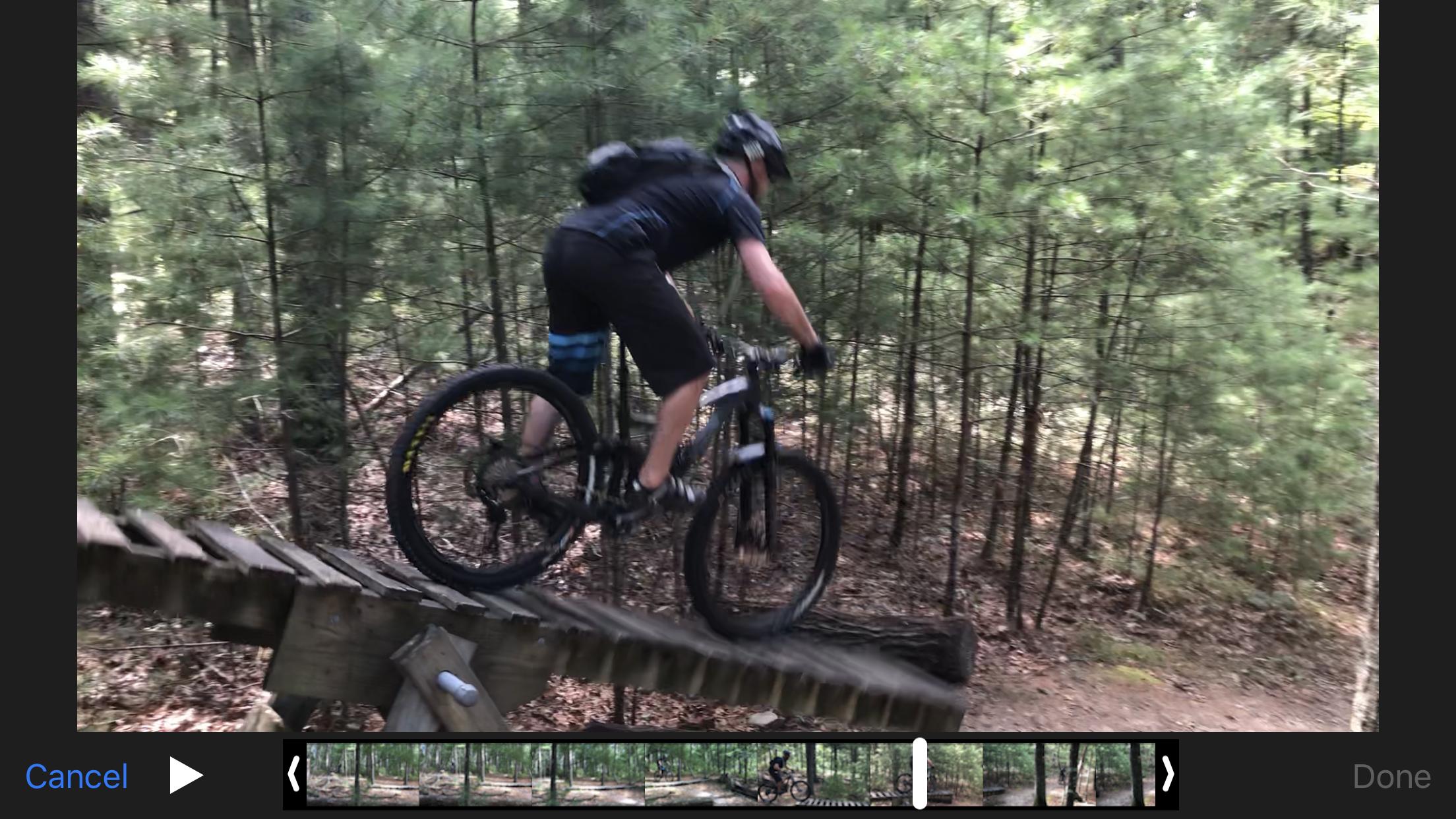
| ThankSo I live only 20 minutes away from this location and I frequent Wompatuck which is 30 minutes away. I just went to the North Hills Marsh area (Duxbury) today for the first time and it offers a great deal of ups, downs, single-tracks, fire-road, and obstacles. The only main difference from Wompatuck and Duxbury is that Duxbury has a very similar trail grade throughout: needles, soft soil, and stumps. Wompatuck offers a greater variety. However, Duxbury Woods are extremely tranquil and serene and you don't find too many people there which makes for a peaceful trek through the woods. Most of all there was some awsome bridges, small jumps, and cool downhill treks with hairpin turns! I was definitely impressed and definitely not bored!
| ThankThis is in my back yard and one of the best rides out there. It is true that when it is wet it is very slick, but it dries out quick due to the sandy soil. There is a nice sea saw and some easy obsticals. 4 good climbs and one sick downhill, but hard to find. The hardest part is knowing the trail since it can be a 9 mile rt if you know them. Have fun
| ThankGreat day after thanksgiving ride. Trail was slightly slick but overall a great day
| ThankHad a blast here, had to walk my SS up a few wet climbs but all in all it was a great day after christmas ride.
| ThankI liked the areas of switchbacks and the roots. I can imagine this being a great place when dry and even better on a 1x9 hardtail.
I just got back from riding here about an hour ago and had a great ride! I rode Yellow/Red then rode Blue around the lake a couple times and rode a bunch of unmarked singletrack as well. The Blue trail is really fun and probably the most technical trail there, lots of roots with smooth sections as well, some drops and logs to ride over. Lots of the unmarked singletrack is pretty awesome here too! I really enjoyed it and will definitely be back soon!
| ThankDefinitely more hills and exposed roots than you would expect. Unmarked singletrack is the way to go here, and there is plenty to explore off of almost any trail. Even marked trails are fun. There are some nice up and downs, some real steep stuff in places as well. Sandy mixture on some trails and just watch the exposed roots if it's been a little wet out, they can be slick. Looks like there had been even more singletrack throughout at some point (see some slightly overgrown trails branching off here and there). I crossed the road after riding up the yellow to the right of the parking lot listed above - this section led mostly to private residences so I jumped back to the left of the road. Good time overall - much more trails to explore than one would think. Not a lot of technical riding, but some of the hills are killers.* Review edited 10/2/2010
| ThankExplored yellow and white trails today and the unmarked singletrack around them. Highly recommend the unmarked singletrack. There's more hills back there than you think but it flows. Lots of roots can make small drops or just be ridden over. Fun place to spend a few hours
| ThankGreat trails on the south shore if you like a difficult, but not too challenging XC ride through forests, cranberry bogs, and marshes.
| Thank