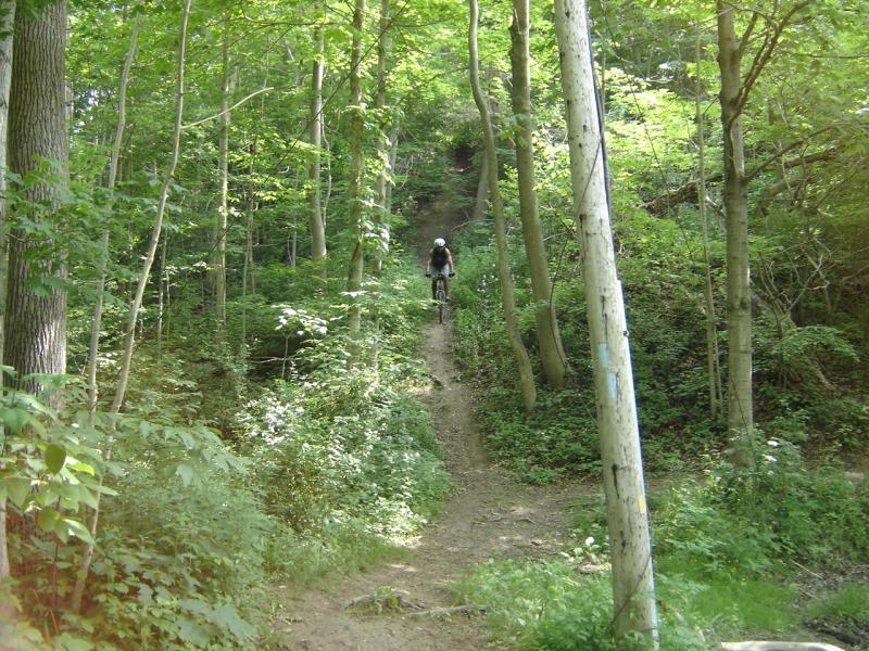
The trail is very rooty/technical in some areas. The loop around the reservoir is about 6km but it branches off to the right before you get to the old condemned bridge in the woods (which is visible from Dalewood drive just before you get to the Conservation office, Look left & down as soon as you turn onto the road when driving there) If you take the right hand turn it is a medium length uphill climb which will get the heart pump’n. Once at the top the entrance to the next trial area can be over grown. Look on your left. If you come to a guard rail at the top you have gone to far but on by a few hundred feet. It will be a down hill along the valley wall. This area is rooty. You will follow this trail for only a few minutes as it goes out into an open area by the creek. The trail goes under Ron McNeil Line (County road 52). The locals call this part of the trail 52. This section will take you out to Highburry Ave where you past over the creek in the valley on your way to St.Thomas. If you cross Highburry to the little Day use conservation area known as Dan Patterson there is about another 3 km loop. Once here go back to the main area and head towards Dalewood again. Go all the way back to the uphill area the started you on your way here but this time when at the bottom of that hill go straight to the condemned bridge. After the bridge there is another uphill, right take you to Dalewood drive and left takes you around the Backside of the Dalewood camping area. Once you come to a clearing that is campsite # 1 cross it towards the back area the trail continues there and it will spit you out at the one lane bridge on Dale wood drive. Cross the bridge and turn right just past the damn. The trail will take you along the creek to waterworks park. Go all the way to the very far end along the creek and the trail will start up again. This area has some erosion issues so you may have to hike a bike for 100 feet or so. This trail will eventually take you out to an area called suicide where some dirt bikers have build up some ramps. As you keep following the trail it will take you to another area called WarddleBottle’s, named after an old local Dirt Biker (Warddle, trials bike, chances are good you’ll see him, he’s about 70!) Take this trail to the end and you’ll come out to a grassy area in a valley follow the trail up to the road (Wellington Rd) and you’ll find Lynhurst Variety store. Turn around and go back. The total is about 21 or 22km.
Note: Dalewood Loop & WarddleBottle’s is very muddy after a good rain and takes awhile to dry up.
This is the Kranky b******s Home Turff…cya out there!


Wet , muddy with some areas with leaves to absorb the water
| ThankTon of fun on a fat bike
Actual loop around Dalewood
| Thanklake was omitted due to extensive recent rains and the whole area is clay .
North of the lake extensive work has been put in by kettle creek conservation authority to reopen 2 sections of the old link to Dan Patterson . North loop at Dalewood and west loop at Dan Patterson are well layed out now after being closed for a few years . The original link trail between the 2 is still not completely rideable with many trees down and the trail disappearing due to lack of hikers. Hopefully they work on that section but it was a still a great work out in bush whacking . Dan Patterson has some well laid out trails in their small 12 acre area .
Great ride for a semi skilled rider challenging in spots. Lots to see, unfortunately some of the trail is closed due to trees falling and can. only do the one loop. Still a great ride.
| ThankIt is definatly a beginner trail but being the only trail accessable by anyone without a vehicle in St. Thomas it is definatly worth a trip.
The route that I took was exclusivly around the reservoir but there is the option to continue the trail all the way over to Athletic and Water works park part of the way across St. Thomas.
The trail did have some rooted sections that could be considered advanced but for the most part it was decently smooth with many smaller roots. There are also lots of small board walks and at some points the trail can become very tight.
I have a few videos of riding the trail with my friends here: https://m.youtube.com/watch?v=j2cRIL0r6Dk
| ThankGreat 6km Intermediate trail that goes around the small lake. The roots are abundant and the trail has some boardwalks to cross along the way. I rode this trail today on my fat bike and will definitely be back. Next time I'll checkout the 52 trail for some of the climbs I've read about.
| ThankFun, rooty technical trail
| ThankGreat Trail for a ride! The maintenance of the trail has greatly improved this year thanks to some dedicated riders and conservation employees. THANKS!
| ThankGood technical trail. Very rooty. No huge hill climbs or drop offs. Decent flow. Good scenery. Abandoned bridge.
Very muddy after a rain. Makes some of the uphills impossible. Clogged my derailleur badly a few times.
| ThankThis trail is a nice one that goes around the lake. It is fairly technical, and a lot more technical than Fanshawe Lake. The loop around the lake is just under 6k (should take around a half hour give or take a few mins), then you can bike past the parking lot and take a right like the description says, but the trails are only a couple km and were a little disappointing. Honestly, I would just do the loop a couple times and maybe do the other trails to finish, or start and end with the lake loop and do the other trail in the middle.
| Thankgood trail with some technical parts....some really narrow sections...part of the trail is meant only for hikers so watch out for the yellow bars on the bridges
| ThankGreat singletrack, awesome ride with the Dan Patterson stretch added in. Good twisty singletrack with lots of roots and such to give it a nice technical challenge. Some minor climbing, except for the big hill near Patterson's park, its a killer.
| ThankSome good climbs pop up right after rooty areas. Watch out for the BIG HILL along 52. We don't know anybody that can climb straight up it! Their is a side trail that winds up incase you give up.
| Thank