Three connected trails. Camp Beale is a loop the other 2 are out and backs. Camp Beale Trail is a 3.2 mile loop with a 500' max elv. gain. Fairly easy trail, but has it's rough spots. This trail connects to Castle Rock Tr. and Monolith Gardens via the underpass. Badger Trail is a 3.4 mile 1100' climb up countless switchbacks, and connects to Castle Rock Tr. Technicaly intermediate. Castle Rock Tr. is the 5 mile connector trail for Badger, and Camp Beale, and continues out to Castle Rock. The section from Badger to Castle Rock gets a lot of traffic, but the section between Badger and Camp Beale gets little. Is actually a sweet intermediate level trail. Whole system can be done as a loop if you want to do a pavement ride on Rt 93, (has wide shoulders, but crossing Rt 93 should only be attempted by daredevils, and those who have already sired the next generation of mountain bikers)
 | Foothills Rim Trail | 10 mi | |
| Monolith Gardens | 20 mi |


These are the trails I like. The surrounding are is beautiful ant the scenery is great for the ride. I do recommend this trail if you are in the area.
| ThankThis is a nice trail with a lot of technical sections. The terrain is mostly loose rock, sand, and boulders. My full suspension bike got a work out on this one. I was only in town for a few hours and made this happen. It was worth it. I did not have enough time to ride then entire Rim but the portions I rode were well worth it. The scenery is nice.
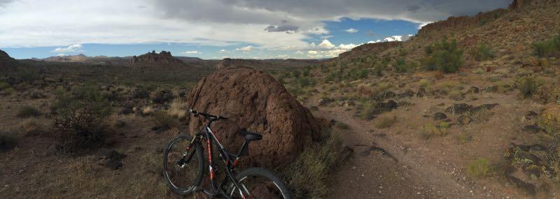
| ThankAmazing views and photo ops! Challenging yet fun lots of technical spots accompanied by lots of fast flowy spots.
| ThankNice trail, pretty flowy. Be sure to know on which trailhead you parked and to get a map. On the trail you will see signs stating TH (Trailhead) but they don't specify which trailhead. I was lost about an hour trying to find the right trailhead. Nice scenery, great open spaces.
| ThankFun trail system.
| ThankI rode the Monolith Gardens Loops and had a blast. The lower loops are pretty smooth ST with some rocks thrown in for fun.
The higher up you go, the rockier it gets. I think this will smooth out as the area gets more traffic.
Kudos to the trail builders for putting together some well thought out trails.
Fun trail system.
| ThankI rode the Monolith Gardens Loops and had a blast. The lower loops are pretty smooth ST with some rocks thrown in for fun.
The higher up you go, the rockier it gets. I think this will smooth out as the area gets more traffic.
Kudos to the trail builders for putting together some well thought out trails.
It was a great trail in very easy to find from I 40. I definetly ride it again if traveling by their future.
| ThankVery nice trail system. There are many different variations. Badger can be done as an out n back and is a very good climb, 1,300 feet in 3.6 miles. Very fun and fast descent on a narrow trail.
| ThankGreat additions to existing trail system. A little more technical than Monolith Gardens, but the scenery is more than worth the effort. A couple of the down hill runs are fast and flowing. Combine with Monolith Gardens trail.
| ThankOne of my favorite trails when I'm in the area. With the addition of the new trails it would take 3 hours to ride every thing this side of Rt 93. Multiple loop options. Also connects to the trails on the other side of Rt 93 via a trail underpass. Also of note; there are cattle here, be sure to close all gates.
| ThankPrimo singletrack, baby! This is a nice, relaxing workout with nice gentle climbs, smooth, flowing downhill and beautiful scenery. Wish I had time to go back again. Its the kind of track that gets better each time you ride it. DONT LEAVE VALUABLES in your car! I parked in the lot on a weekday morning and noticed at least four piles of broken car window glass, no doubt evidence of recent breakins!
| Thank* Review edited 8/24/2011
| ThankVery scenic riding on speedy single track. Lots of unique areas, especially around the north-western corner of the loop. Some fun techy spots, good flow overall. The one out-and-back is a blast both ways, but definitely not beginner friendly. Some challenging climbs up from Monolith Gardens that make for fun, fast descending in reverse. Lots of loop combo possibilities. Check it out!
| ThankVery nice easy ride with unique rock formations. Connect with Desert Foothill trail system to add distance and technical singletrack. * Review edited 8/1/2011
| ThankVery fun scenic trail with moderate climbing. Many different loop configurations. Some very nice fast downhill singletrack sections.* Review edited 8/1/2011
| ThankFast single and double track loop system
| ThankGreat loop trail, fun and fast. Great technical out and back section.
| Thank