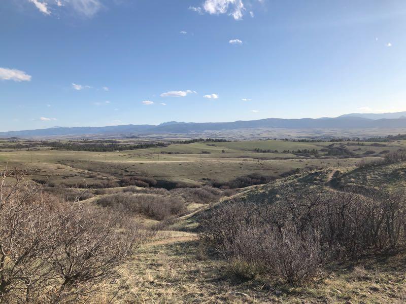
The section of trails at Highlands Point can be accessed from Mountain Vista High School or via the East-West Regional trail parking lot on Griggs rd. Note that all but two of these trails are gated for HR residents only. Trail is accessed by taking the paved bike path in back of Mountain Vista HS until it turns to gravel, then just follow that up the hill. The first trail on the right and ahead are the East-West Regional Trail, open to everyone. Continuing straight up the hill, the first trail on the left is the Metro Districts Big-Dry trail, also open to everyone. You can turn left or continue straight up the gravel path to the top (Highlands Point) and continue on the East-West Regional trail to the Griggs rd. parking lot. The view at the top of Highlands Point is excellent, markers point out Devil's Head Peak, Mt. Evans, Chatfield, etc. The gated trails off to the left and right provide access to approx 7mi of private HR trails. Trail builders built large "bumps" every 100ft or so on some sections to prevent erosion. Overall, a mixture of narrow and wide singletrack, great views, along with intervals of short uphill and downhill sections make this a really fun trail with a roller coaster feel to it.


Very easy, flowy at times trail. No real features on this ride. In areas the trail is triple track but will funnel down into double track throughout most. During the summer, there are quite a few blind corners and significant switchbacks that are all meant to slow down mountain bikes. You must bring a bell on this ride or you may endup in a headon collision.
Its a great trail for someone looking to get their heart rate up and sweat a little. There are races that take place here, and it can be a challenge. While it is a beginner course, the climbs are long and can be in the 10-12% grade for a decent amount of time.
| ThankThey just added 13 more miles of bmx type single track.
| ThankTrails are good for quick rides, nothing real technical. This time of year there are sections that are in the shade so still covered in ice and mud from the melting, but it is not bad at all. Lots of fun for a nice quick ride.
| ThankThis is a great trail system for anyone who lives in the southern Aurora/ Centennial part of town. I really enjoyed the roller coaster feel with just enough uphill to get your heart pumping. The descents are pretty fun... Nothing crazy or technical. Just some good flow with a few jumps and fast sections to boot. Overall I would definitely recommend this trail for anyone looking for a great time with a descent amount of mileage.
| ThankEasy but can be fun
| ThankThe section of trails at Highlands Point can be accessed from Mountain Vista High School or via the East-West Regional trail parking lot on Griggs rd., or better yet just ride there from your house in Highlands Ranch since all but two of these trails are gated for HR residents only. Trail is accessed by taking the paved bike path in back of Mountain Vista HS until it turns to gravel, then just follow that up towards the top (Highlands Point). The first trail on the right and ahead are the East-West Regional Trail, open to everyone. Continuing straight up the hill, the first trail on the left is the Metro Districts Big-Dry trail, also open to everyone. You can turn left or continue straight up the gravel path to the top of Highlands Point and further on to the Griggs rd. parking lot. The view at the top of Highlands Point is excellent, markers point out views of Devil's Head Peak, Mt. Evans, Chatfield, etc. The gated trails off to the left and right provide access to ~7mi of private HR trails - fast and fun although a tad wide in some sections. I don't love the large "bumps" they created every 100ft or so to prevent erosion, but i guess it gives the trail a bit a motocross feel if you like that. Great views, along with some short uphill and downhill sections keep it interesting.* Review edited 7/22/2012
| ThankSo I live in Denver, and had to ride this trail with hopes of not getting caught by the highlands ranch elightest. What is the the deal with that! I say from now on when riding the vast expance of Colorado trails. We carry our id's and check oneanother. If someone happenes to be from highlands ranch, we kick them of the trails, by saying these trails are not for you our city paid for them. It's ok anyway these trails are to easy for anyone not living in highlands ranch to enjoy.
| ThankThis is a review of the NEW trails in the HR backcountry. There are 5 miles of additional trails off the back of Highlands Point. They are all pretty easy, with very little climbing. The Tenderfoot section is about 2 miles downhill (going west) with plenty of jumps. There is some beautiful scenery of the front range and the backcountry throughout. Not epic by any means, but a great ride and pretty easy. This will soon connect to the Monarch backcountry via the East-West Douglas county trail (Fall 2009).
| ThankA decent little ride, with few challenges. A good trail if you are pressed for time, but want to sneak in a ride before sunset.* Review edited 7/15/2008
| ThankThis is a fun trail if you live in the area but it is too short. I cant wait for them to expand it.
| ThankThere are three different areas of this same trail that have not yet been connected. Once the three trails are connected (In Aug. '08?) there will be a decent length loop available with varying difficulties and single-tracks. The trail will take you from the west-most edge of Highlands Ranch "ridge", east to Wildcat Ridge and than south to the east-most ridge in Lone Tree. Or so "they" say.* Review edited 7/20/2008
| Thankeasy trail few options hrca is expanding it to monarch backcountry
| ThankThis is a fun trail with a nice little climb at the begining. This trail is definetly longer than 1 mile, if you include the climb up and descent back down, it is probably about 5 miles long. HRCA is planing on lengthening the gravel road part so that should make it even better. The single track starts on the left side, near the top of the climb, ignore the first one and take a left on the second. It's just my preference, but I beleive it is the best direction to ride it. The only problem with this trail is that it is technically for Highlands Ranch residents but there is really no way to tell if you are or not. But, really this ride is nothing special, it has a few fun parts, but if you are out on a ride you should go out to a reall trail, not just a little community trail.
| Thank