×

|
Rate it:
Tags:
Level: Intermediate
Length: 10 mi (16.1 km)
Surface: Singletrack
Configuration: Out & Back
Elevation: +1,168/ -1,105 ft
Total: 50 riders
Mountain Biking Arnold Rim Trail
#90 of 1,015 mountain bike trails in California
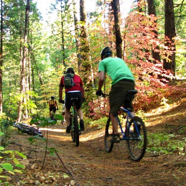
Set in the beautiful terrain of the Stanislaus National Forest there is a large variety of trails here built over the last couple decades plus dozens of miles of old Forest Service roads that have been closed too motorized traffic for several years now. Through a lot of planning and hard work in order to better organize this network of trails the locals have built the ART to serve as the main singletrack route through the area. The ART utilizes singletrack for most all of its 10 miles however there are a few short sections of FS road still in use, singletrack is continuously being built to reroute around these sections. Signage is adequate and also constantly being improved upon, delineators Forest Brown in color with an ART sticker and arrows mark the route. The route does takes you up and over the ‘Top of the World’ (see trail description) and actually uses some of the same trail. From the peak riders are treated to a view of the Sierra Crest to the East and all the way out to the Coastal Range towards the West on very clear days.
This terrain is far from flat so expect to climb quite a bit however the payoff is swoopy, fast singletrack through some amazingly beautiful forest. Occasionally the trail splits into a technical route with an easier ‘ride around’, these are marked with the typical Black Diamond vs. easy or intermediate ratings.
There are many other trails that either originate from or cross the ART, watch for these descriptions here in the future as these routes become defined and signed.
First added by AK_Dan on Oct 25, 2009. Last updated May 11, 2020. → add an update
Before you go
- Drinking water: unknown
- Lift service: unknown
- Night riding: unknown
- Pump track: unknown
- Restrooms: unknown
- Fat bike grooming: unknown
- E-bikes allowed: unknown
- Fee required: unknown
This trail information is user-generated. Help improve this information by suggesting a correction.
Avery: From Hwy 4 in Avery about 4 miles before Arnold, turn West on Avery Sheep Ranch Road. Proceed West approx 1.5 miles to an unmarked (except for park info signs slighly off the road) dirt road on the right. (County Rd 323) Several parking areas are available at varying distances up this road on the left side. Look for the ART markers on the north side of rd 323.
White Pines (Arnold): From Hwy 4 at the eastern edge of Arnold, turn NE on Blagen Rd. Trailhead and parking are near the Sierra Nevada Logging Museum at 1605 Blagen Rd, near the southern end of White Pines Lake.
There are additional access points, some within Arnold, however at this time there are issues about parking within the neighborhoods, as soon as these are resolved directions to these will be posted.
1 mile before Avery on hwy 4 there is a Forest Ranger station on the right, it is highly advisable to stop here and ask for a map and other info on this area. The local rangers here are very proactive about these trails, new construction and the progression of the sport within their jurisdiction.


Fun trail system. I've ridden it from the logging museum in arnold to the helicopter pad near Avery and back. There is some really nice single track available along the way and plenty of fun stuff if you know where to look. P12 is epic and should only be ridden from North to South. My only complaint is the trail marking. There are lots of little trails that cross and you can easily take the wrong turn. The area South of sheep ranch road (San Domingo) is awesome and much less traveled, however there is a series of switch backs nearing the helicopter pad in Avery that can be skipped unless you like climbing. The equestrian trail on the North end is also fun, granted you have to take gravel roads back to the logging museum (white pines lake) area. I go this route on the way back vs taking the paved trail for variety. Btw. Keep in mind that every foot you decend, you'll be climbing on the way back.
| ThankLots of great downhill, but you pay for it on the uphill. Beautiful single track. Fun ride for intermediate of above. Don't bring a newbie
| ThankA great trail runs along the top of the ridge, single track in and out of the trees a few stream crossings, nice views trails are marked well, grab a map at the Ranger station your set.
| ThankThis trail system is great. Never knew it was right in my backyard for the most part (SanJoaquin County). Easy access and the trails are well marked. Nice sweeping sections of down hill single track, but you have to pay to play here. There is just as much up as down no matter if you shuttle or not (that I found). You can download a trail map at http://test1.gocalaverasfoodie.com/wp-content/uploads/2009/10/ART_Trail_Map_9.09.pdf This trail can be an all day adventure and it's hard to get lost. It can be ridden how ever you choose because most all trails connect. There are trails newly created that are not on the map. The trail is not heavily ridden but you run into the occasional MTB'er, hiker, and I saw horse goo. Overall fun, bring food for lunch at "The Top of the World" where you can see Mt. Diablo on a good day. The views are sweet. Not much technical terrain depending on what you are used to. Mostly smooth single track with some areas covered in pine needles and loose dirt (careful on turns), some small areas to catch a little air, and most climbs although steep are not very long.
| Thankthis trail system is awesome, there is something for everyone. Plenty of technical tracks with everything from roots to log rides, ruts and jumps. definitely get a map, i spent most of the day lost, but trails are marked just not very well, if you have a gps, bring it! cant go wrong with this spot beautiful views betters rides
| ThankDuring a recent IMBA trail crew visit about 30 locals gathered to reroute a bad sections of trail near the ‘Top of the World’, a great turn out for such a small community. Everyone of them was excited and eager to brag about the area and share trail info. Visit Arnoldrimtrail.org for updated info, the map itself is still being updated as sections are being rerouted. Once again a stop by the Ranger Office on hwy 4 is a good idea, the local rangers although working on a very limited budget are open to ideas and suggestions here so feel free to chat with them about the trails system.
| ThankThe Bear Valley ski resort and bike trails are about 25 miles up highway 4 and the locals tell me there is more than one route of trails all the way from there down to the Arnold area.
The org is constantly working with the local home owners to obtain better parking areas and access to the system. Please be courteous and only park in specified areas, if in doubt please just ask.
I didn’t take many photos on my ride there however the trail description for the Top of the World has several that will give you a good idea of the terrain, there is also a GPS map there of quite a bit of the immediate network mapped.
Through planning and a lot of hard work this is soon too become a great weekend destination for riding less than a couple hours from Sacramento, watch for this place to really grow in popularity.