singletracks is mountain biking
 
Trail is Unknown Status
on 8/6/07 by bonkedagain
 
  
Avg Rating: 1 trail review
Difficulty: Advanced bike trail - Advanced
Length: 16 miles Global Rank: #807
Tread: Singletrack Configuration: Loop
Ridden: 1 Wishlist: 5
0 trail check-ins


Directions
To view directions to St. Charles mountain bike trail, please login. If you don't have an account, sign up for a free account - it only takes a minute.

Description
If you like sweet singletrack this is not it. This trail is for people who don’t mind pushing their bike up miles of steep rocky trail and get a grin when looking down steep rutted switchbacks that are covered with rocks and roots. Motorcycle riders are the most common users of the trail and they leave their telltale mark on it.
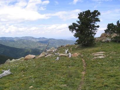
The ride is a loop that includes four miles of highway riding (State Highway 165 north of San Isabel) and about a mile of the Cisneros Trail climbing out of the San Isabel recreation area. It is about an eight mile climb from San Isabel Lake at about 8600’ to near the top of St. Charles Peak at 11,784’. From the top you have a steep four mile descent that is made up of seemingly endless switchbacks. Ridden in the clockwise direction, you will push for miles going to the top – much of the trail is either too steep or has too many rocks to stay in the saddle for extended periods of time. There is some very nice singletrack in the Beaver Creek drainage and there other sections scattered along the trail that are good riding, but the majority of this trail is made of lung busting climbs and b*** puckering descents. The scenery is great -- this is one of the higher peaks in the Wet Mountains. The Sangre de Cristo Mountains are close by to the west; Pikes Peak to the north, the plains to the west. Oh, and do you know why they call them the Wet Mountains? Yeah, it rains a lot, so it is typically very green, lush, and damp. The ruts are so bad in some places that the trail captures the streams and thus you are riding down streambed for hundreds of feet. Be prepared for some axle deep puddles and mud holes. I rode it in six hours, taking my time, enjoying the sights, and taking a side trip to hike the remaining couple hundred feet to the top of the peak for lunch.

added by bonkedagain Gnarly on August 6, 2007

Trail Reviews   [Add a review]

gatzke on August 30, 2008
0 out of 0 readers found this useful
 
Review: For all of the downhill fun without most of the rough climbing at altitude, shuttle this ride. Get dropped at the upper St Charles Peak trailhead, which is along Greenhorn Mtn Rd (GMR) at over 11,000 ft, and picked up at either of the lower trailheads (@ ~8,500 ft) - one is at the Cisneros TH in the Lake Isabel Rec Area (~8 mile ride), the other about 4 miles north of the Lake along Hwy 165 (~7 mile ride). This gives you 2-3,000 feet of steep and challenging descending with minimal climbing (the route ending at the Lake [Cisneros TH] requires less climbing than reaching the Hwy 165 TH, which involves some uphill at around the 2 mile mark, 11,500 ft up). These and other downhills leaving from GMR are excellent rides in a beautiful alpine setting. To reach FS Rd 369 aka Greenhorn Mtn Rd (GMR), travel north from Lake Isabel on Hwy 165 for around 5 miles to the small "town" of Fairview, and take a left turn onto FS Rd 360. This is also marked as the turnoff for Ophir Campground. Stay on FS Rd 360 for about 10 miles (when the road forks shortly after the campground, stay left), until you reach a four-way intersection with FS Rd 369 (GMR) breaking off to the left. This road follows the crest of the Wet Mountains south, almost to the top of the highest peak in the range, Greenhorn Mtn (12,347 ft). The upper St Charles Peak TH is a little over 2 miles up this road on the left. About 1.5 miles into the trail (just after the old logging road peters out and the singletrack begins), it splits - go left to end up at the Hwy 165 TH, right to dump out at Lake Isabel at the Cisneros TH.

Similar Trail: The Cisceros and Snowslide trails also have upper trailheads along GMR (appoximately 9 and 11 miles, respectively, up GMR) and drop out in the Lake Isabel Rec Area. The lower Snowslide TH is at the entrance to Lake Isabel, the Cisneros TH is at the back o

Was this Review helpful? Yes | No
 

Recommendations

Lion Canyon Loop (100%)
Squirrel Creek (100%)


Colorado Outdoor Lists


Copyright 2013 Blue Spruce Ventures LLC | Decatur, GA  
singletracks.com is yet another slick Review App