×

|
Rate it:
Tags:
Level: Intermediate
Length: 9 mi (14.5 km)
Surface: Singletrack
Configuration: Loop
Elevation: -
Total: 10 riders
Mountain Biking Kennison Mountain Trail
#20 of 112 mountain bike trails in West Virginia
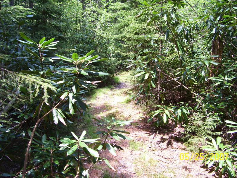
Leave Vistors Center going west on Rt.39, cross the top of the mountain and watch for the next fire road on the right (FR232 Dogway Rd.) Take FR232 to the gate and park. Take Frosty Gap trail on the right when looking at the gate. Ride Frosty Gap for about a mile. Take Kennison Mtn. Trail to the left and follow it till you come out on a grassy fire road. Along the way there are rock gardens, root gardens, some very scenic pine forest, some climbs, some downhills, and a couple neat boardwalks. Go left on the grassy fire road and follow it to intersection with FR232. Go left on FR232 and climb back to the gate. Not a difficult climb, just steady. Total loop is around 9 miles. This is a must do if you are in the area.
First added by Outdoornut on Feb 5, 2008. Last updated May 6, 2020. → add an update
Before you go
- Drinking water: unknown
- Lift service: unknown
- Night riding: unknown
- Pump track: unknown
- Restrooms: unknown
- Fat bike grooming: unknown
- E-bikes allowed: unknown
- Fee required: unknown
This trail information is user-generated. Help improve this information by suggesting a correction.
Only using part of Kennison Mtn. Trail for this loop. Not recommended for XC beginners. Intermediate riders should be able to enjoy this trail and learn some new skills. A little over 1/2 this loop is singletrack, the other half, fire roads.
Kennison Mtn. Trail actually starts off Pocahontas Trail a couple miles west of the Cranberry Visitors Center and crosses Rt.39 and will take you all the way to the Cranberry River. (Note: no crossing at the Cranberry - Thigh deep ford only to the Cranberry River Trail). That is why loop is recommended.


Super techy trail with lots of beauty. Not for the weak. Trail is clear and in great shape! Now is a great time to ride it.
| ThankKennison Mountain is back! So good it should be illegal. Dark, lush, thick. Middle Earth with elves, ents, and orcs.
| ThankUPDATE ! A couple friends and I took our handsaws with us on a trek out Kennison Mtn. Trail and were able to make it ridable. If you want to ride this awesome trail now is the time to do it before some more trees come down. It is grown in pretty tight in a couple spots but if you love this trail like I do, go enjoy it. Warning, South Mountain trail is washed out pretty bad in places, a bridge is broken down and nettles 3 to 4 feet tall. Cowpasture has some weeds 5 feet tall for about a 1/2 mile, other than that it's in good shape. Even with the growth, it's a unique ride. Loved it.
| ThankWell had a friend checked this trail and said most of the stuff from 2008 had been cleaned up although there is a bunch of new stuff down now. Should be able to get it cleaned up before July and the Slatyfork Shuffle. I'll post more when we get it done. This trail is a must do. If you ride like the last reviewer did, you can take a left off the gravel road onto cowpasture trail. When you get about 3/4 the way around you'll come out on an old road, where you will see some old blacktop under the tall grass. Take a left here instead of right on the trail (old road). Ride up the grassy old fire road and you'll come out at the stop sign across from the vistors center. Saves climbing a big climb up the blacktop road just to get back to the vehicle.
| ThankThis is a special trail. About the deepest, darkest woods I've ever encountered on wheels.
The real magoo is to take Pocohontas Trail from the visitor center climbing to where in connects to Kennison Mountain Trail. Cross the highway, and continue until you attain the top of the ridge. You'll ride along the top of Kennison Mountain crossing a couple of fire roads. Keep going until the trail drops steeply into the Cranberry River. Wade across the Cranberry and then follow the gravel road back upstream to Cranberry Glades parking lot. From there it's a short climb back to the visitor center - many, many miles - West, by God Virginia at its finest.
And, one more thing, wilderness designation WON'T take this trail from bikers. Don't be scared, it's a good thing.* Review edited 11/9/2008
* Review edited 11/9/2008
| ThankNOTICE ! Checked Kennison on August 30, 2008 and it's still covered with fallen trees. No one has touched it since June when there were at least 20 or more trees down on it. Frosty Gap still has several on it as well so don't waste your time trying to ride it this year. Looks like I'll have to make a 4 hour drive to work all day on this trail. I'm disappointed with the forest service and have sent them an email voicing my displeasure. I will still rate this trail as I would if cleared. I'll let everyone know when it's finally clear.
| ThankJust attempted to do an Epic utililizing Kennison Mtn. Trail the week of June 16 thru the 22nd, 2008 and was very disappointed with all the down trees. At least 30 or more that required crawling under, over or bushwacking to get around. Very disappointed in the National Forest Service for not getting this awesome trail cleared. There were a couple down on the south side of Rt.39, not sure about between Rt.39 and Frosty Gap, we dropped that section from our route, however the section from Frosty Gap north to the second fire road had way, way toooo many down. Might give it a while before you try it. check Frosty Gap, if the 10 or more trees are still down there it's not worth taking Kennison. The trail is great, just not right now. If anyone checks it later and finds it clear, please let us know.
Epic was to take Pocahontas from Cranberry visitors center, then Kennison to South Mtn., over to Dogway, up to Frosty Gap, Frosty Gap to Kennison, north on Kennison to the second fire road, take a right, then another right in a short distance and follow that fire rd back to dogway rd.
| ThankLeft on Dogway to Frosty Gap, up Frosty Gap again,
then south on Kennison, down the mtn. to South Mtn., take a left on South Mtn, and ride it to Cow Pasture at the Cranberry River Trail. Take Cow Pasture (which is known to be clear right now) and a left on the old fire rd near the end of the trail which will lead you out to the stop sign on Scenic Hwy. 150 across from the Visitors Center. Approx. 28 to 30 miles.