In general, mountain bike trail systems are not static entities. Most trail systems morph and change, continuing to develop over time. As we zoom the lens out, we see that even mountain bike destinations continue to grow and change, with most destinations getting better and better as the years pass.
We’ve written numerous articles about the best mountain bike destinations across the United States (and beyond), but as I talk to fellow riders about these top destinations, I often hear responses like, “I rode Moab a bunch of times back in the 90s. I’ve ridden everything there is to ride there, so I haven’t been back in 20 years.”
Oh, how wrong you are my two-wheeled compatriot! Not only have all of the top destinations in the nation changed dramatically since the 90s, but even in just the past year or two we’ve seen dramatic changes in the mountain bike landscape, with new trails being constructed all around the planet.
I first published the article, “The Top 10 Best Mountain Bike Destinations in the USA” back in June, 2016, itself an extension of a similar areticle. How have these 10 best destinations changed since that article was written less than 2 years ago, and is a return visit to these places worthwhile? I decided to find out.
Moab, Utah
I’m always shocked when I hear that Moab is past its prime and that it’s time to look elsewhere for great singletrack. On the contrary, the folks in Moab build new singletrack so routinely that an annual visit to this great destination, which we chose as the Mountain Bike Capital of the United States, would yield a new trail–or even a brand-new trail system–every year.
Rodeo Trail
The newest singletrack in Moab is the Rodeo trail, completed in May of 2017. This new singletrack forms a loop off the Chisholm trail, south of Horsethief Campground. Despite being just a single loop within an existing trail system, this trail is over 9 miles long–a complete ride unto itself for many people. With a beginner to low intermediate difficulty rating, this could be the perfect trail to challenge new riders with short technical stretches, and a slightly longer ride than they might be used to.
Rodeo “is unusual in that a lot of it is through the trees,” according to Michele Hill of Discover Moab. The “surface is a mix of dirt, slickrock, and sand.”
Coming Soon
While Rodeo isn’t brand spanking new, Moab Trail Mix does have several projects in the works that could be announced in the near future, but aren’t yet ready for the public eye. Stay tuned!
Crested Butte, Colorado
Most of the singletrack trails in Crested Butte date back decades (or longer), which is one reason why Crested Butte can claim to be one of the birthplaces of mountain biking. Due to the hundreds upon hundreds of miles of singletrack that already surround Crested Butte, not nearly as much singletrack gets built here year in and year out as it does in places like in Moab. “With the amount of trails we have, ranching and private property, along with wildlife and other environmental concerns, we don’t have hordes of new trails planned as much as we have connections and opportunities to make loops and stay away from pavement/roads,” said Dave Ochs, Executive Director of the Crested Butte Mountain Bike Association (CBMBA).
Baxter Gulch Trail

That said, one new trail that is almost complete that will form one half of a burly from-town loop is the new Baxter Gulch Trail. Currently, 5.5 miles of the trail has been completed, and it is rideable as an out-and-back. Once the snow melts this summer, CBMBA needs to finish the last 0.5 miles to connect it to the Carbon Creek Trail. Once connected to the Carbon Creek Trail, riders can then pedal over to the Green Lake Trail, which drops into downtown Crested Butte. All told, once Baxter Gulch is connected it will help form a roughly 12-14 mile loop from downtown Crested Butte that’s almost 100% singletrack.

Here’s how Ochs describes the trail:
“The trail is a bit of a beast — as in it does a good bit of climbing right off the bat. Not for the wary of climbing, she goes up! Leaving from town/trailhead, the trail needed to gain elevation immediately in order to avoid private property issues. So up and away it goes, switching back quite a bit along the southeastern flanks of Gibson Ridge in fields of aspen, remnants of the mining past, and across open fields with amazing views of Mt. Crested Butte and the Gunnison Valley.
Once above the private parcels below, it traverses across Gibson Ridge, then descends into Baxter Gulch in order to cross sides of the drainage where the trail truly resides — on the lower flanks of Whetstone Mountain. From here, and now in the dark timber along Baxter Gulch itself, again the trail climbs to gain elevation in order to reach federal lands. Traversing across the hillside, bench cut trail has been tediously put in through drains and steep embankments over the course of 6 years to get to the USFS boundary and some more tame terrain to work with. 3.5 miles in you hit public lands and are staring at the beautiful flanks and talus fields of the mighty Whetstone Mountain itself.
Now the real fun begins, as the trail meanders through aspen forests, dark timber, [and] beautiful open meadows while skirting the talus fields and tree line on Whetstone. The trail then makes a final push up through the dark timber to gain the saddle itself and [a] view down on the Ohio Creek Valley.”
While over 6 years of work for a 6-mile trail may sound tedious, this loop is guaranteed to become an instant Crested Butte Classic!
Lake Tahoe, California and Nevada

Like many other destinations on this list, the Lake Tahoe area is home to a longtime classic: the Flume Trail. Nowadays, the Flume Trail might be one of the least interesting trails in the Lake Tahoe area, as the Tahoe Area Mountain Bike Association (TAMBA) has radically expanded the network with bike-optimized singletrack.
Angora Ridge Trail and Mule Deer Trail
TAMBA oversees the mountain bike trail development around Lake Tahoe, and in 2017 they “partnered with the US Forest Service to build 5 miles of brand new singletrack around Angora Ridge near South Lake Tahoe,” according to Ben Fish, President of TAMBA. “TAMBA granted funds to the Forest Service to rough cut the trails, then held more than 60 volunteer trail days with about 150 volunteers contributing 2,000 hours of trail building.”

The two new trails are known as Mule Deer and Angora Ridge. Mule Deer is a smooth trail that’s very approachable for all riders, whereas Angora Ridge is very rocky, due to following the spine of a glacial moraine. “Both trails offer expansive views of the mountain ranges, Fallen Leak Lake, and Mount Tallac,” says Fish.
Coming Soon

TAMBA plans to build another 3-5 miles of singletrack in this same area in 2018, “by connecting from Angora Ridge to Fallen Leaf Lake. We are also taking on trail projects in Kings Beach and Tahoe City on the North Shore of Lake Tahoe along with two trail projects (Tamarack Lake and Belli Front) in the mountains between Reno and Tahoe,” says Fish.
Park City, Utah

Park City, Utah was the first destination to be granted IMBA’s coveted Gold-Level Ride Center designation. While it has since been joined by a few other destinations, gold is still a rare label, with most destinations receiving silver or bronze status, if they qualify at all. In order to stay on top, Park City has kept building singletrack, with numerous different entities contributing to the overall breadth and quality of the trail network.
Wasatch Over Wasatch (WOW) Trail
Since our previous article was published, the Wasatch Over Wasatch Trail (WOW Trail) has been the biggest singletrack development in Park City. The WOW Trail “starts in Bonanza Flats on the backside of Empire pass, and finishes in Midway at the bottom of the Guardsman Pass Road,” according to Scott House of Jans/White Pine Touring in Park City.

The trail is about 12 miles long and begins with a roughly 800-foot climb. “After that it’s close to a 2,500’ descent into the Heber Valley/Midway,” said House. “It’s a machine-cut trail but already has an incredible riding line in it. It travels through a couple different environments from aspen groves and pine forests to high desert and scrub oak forests. Lots of flow with just the right amount of tech and challenge to keep it fun for most abilities. The trail offers some of the best views you can find on a ride, including the southern Wasatch, Mt. Timpanogos, Cascade Peak, and even gets views on turns back up Snake Creek canyon and into the central Wasatch. It’s easy to shuttle, from Park City or Midway, but you could also pedal up from Park City to the top and get a ride back from Midway. At the bottom, the trail connects into Dutch Hollow, which has some fun singletrack as well.”
High Star Ranch Trail System

While technically located outside of Park City proper, High Star Ranch is a new trail system that was built by Sagebrush Trails from the ground up for mountain biking. “The uphill routes are well-graded and get you up the mountain fast without zapping your legs,” says House. “The downhill options were obviously built by people who ride bikes, with lots of line choices and fun features. It really is one of my favorite new spots to ride.”

Coming Soon: Deer Valley Flow Trail
Deer Valley Resort is planning to build a new flow trail from Silver Lake Village to the main lodge below. “This will connect the main bike park to the lower lots and will be an awesome addition to riding in Park City,” says House.
Wydaho, Wyoming and Idaho

Wydaho is a relatively large area spanning from Jackson Hole, Wyoming to Driggs, Idaho (and beyond) that still manages to function as a cohesive destination. Like Park City, the trail development in this area isn’t the result of just one organization working really hard, but rather the collective achievements of all the builders and trail developers in the region. Everyone benefits from more singletrack!
Rocky Mountain Way

Grand Targhee Resort continues their never-ending trail development on the Teton side of Wydaho, and the newest addition in this area is the Rocky Mountain Way trail. This new three-mile section of singletrack connects to the Mill Creek Trail, which is a must-ride. “From the base area of the resort, you can hop on AJ’s Trail at Grand Targhee Resort and access the 3 beautiful miles [of] Rocky Mountain Way descending into Mill Creek to the Teton Canyon floor,” says Mitch Prissel, Manager of Habitat Bike Shop in Driggs. “My favorite [route] with time is climbing up from Teton Canyon on Mill Creek to Rocky Mountain Way and descending back down Colter’s Escape to Mill Creek and the Canyon below. You’ll earn it and you’ll love it. So much more can be added to this ride but this is a good start.”
Skyline Trail
On the Jackson Hole side of the mountains, the new Skyline Trail, just completed last year, offers up 7 miles of singletrack “overlooking [Jackson Hole] and the Tetons that you grunt and rally down, earning every bit of a smile,” according to Prissel. This trail can be connected to the Cache/Game network of trails, which is one of the highest-rated trails in Wyoming according to Singletracks reviewers.
“It’s accessed right from the town of Jackson near Snow King Mountain Resort,” says Prissel. “You can easily turn this into a day ride with 20+ awesome miles if you want.”
Coming Soon: Pole Canyon Connector
Other trails currently in the works on the Teton side include the two-mile Pole Canyon Connector trail from Mail Cabin to Pole Canyon. This trail has already been roughed in, but the real trail work will take place this year. Back up at Grand Targhee, Andy, the resort’s trail-building phenom, has a new 7-mile slice of heaven in the works this year.
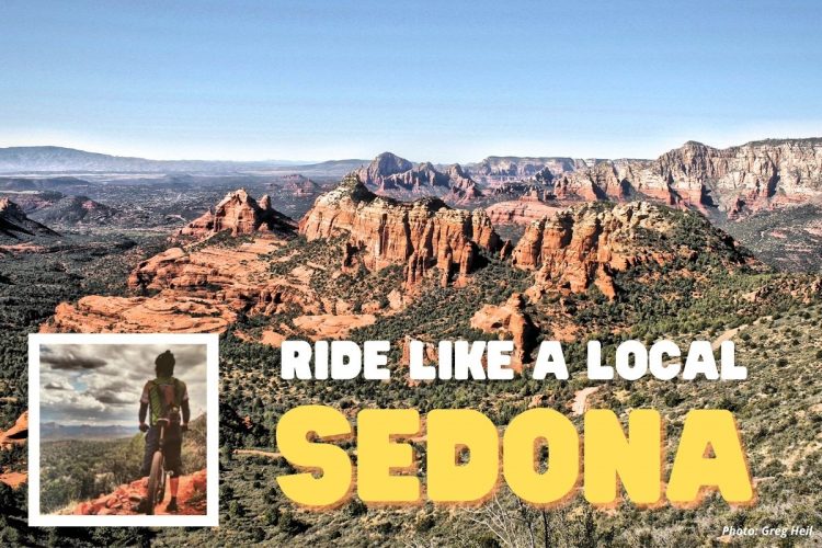
Sedona, Arizona

On a map, the trail development potential in Sedona appears severely limited. The current trails are already routed through and around town, appearing to cover the region. The town of Sedona and the greater mountain bike trail system also appears hemmed in on all sides by Wilderness areas, where bikes are not allowed. And yet, the folks in Sedona continue to build new trails.
While the announcement of Sedona’s new 27-mile Western Gateway trail system made waves on social media, construction of this new trail system isn’t set to begin until Fall of 2018. However, several new trails in Sedona have already been built since our top destinations article was published, forming an excellent singletrack loop.
Scorpion, Pyramid, Sketch, and Skywalker Loop

The Scorpion, Pyramid, Sketch, and Skywalker trails were all built around the same time, and together they form a respectable loop. Scorpion is roughly two miles long and intermediate in difficulty; Pyramid is a one-mile black diamond descent; Sketch is also a one-mile, black-diamond descent; and Skywalker offers two miles of intermediate singletrack.

“In addition to amazing scenic views of Cathedral Rock and Courthouse Butte in the distance, [Scorpion] drops roughly 500-600 feet through an array of terrain: embedded basalt rock, smooth red dirt, and across slickrock,” says Matt McFee, owner of Hermosa Tours. “It’s technical in spots, it’s smooth and flowy with some jump lines in others, and even sports a few small drops.”
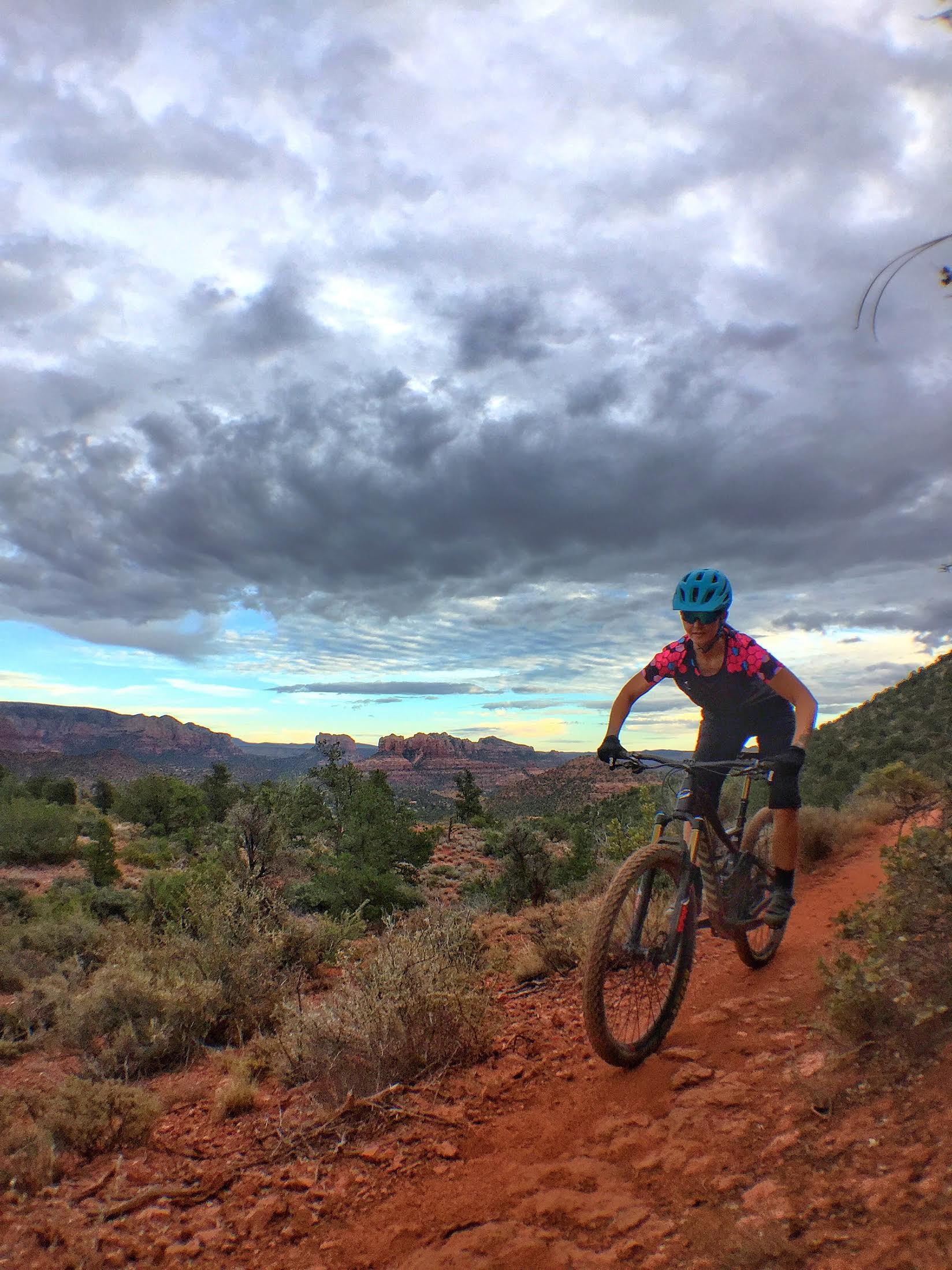
Of the segments in this loop, the newest portion is the Skywalker trail. “[Skywalker] connects the Herkenham and Old Post trails, where the latter starts at the Red Rock High School,” says Kevin Adams of the Verde Valley Cyclists Coalition. “Skywalker is an intermediate ride with a few exposed sections and one sharp turn that I have yet to figure out.”
“No matter which way you take Skywalker, you’re initially climbing, but the 360-degree panoramic views at the top are breathtaking and worth the exertion to get there (and then you get the descent),” Adams says. “Skywalker, and all the trails in the Carroll Canyon area south of 89A in central Sedona, are the first we ride after a rain as they tend [to] shed water and dry much faster than our other trails.”
Brevard, North Carolina
Like Crested Butte, much of the singletrack around Brevard, North Carolina–most of it located in Pisgah National Forest–is ancient trail that dates back to time immemorial. But the deep forests and wide swaths of public land by East Coast standards offer plenty of opportunity for turning old, unsustainable trails into bike-optimized singletrack, and for building connections between existing trails..
Spencer Gap
Spencer Gap is one of the newest trails in Pisgah National Forest, thanks to a recent rerouting of the old-school trail in this area. “It is a mix of flow and technical throughout,” says Jeff Keener, President of Pisgah Area SORBA. “There are three alternate lines at various points which are very technical, and the trail overall has a lot of flow and speed. We tried to mix classic Pisgah and flow into one trail. The whole trail is 4 miles and it is technically divided into three sections. Section 1 is the climbing section off FR5000 and is approximately 1.25 miles long (classic lung-busting climb). Section 2 is the new downhill section in the video [above], which is 1.25 miles long. Section 3 is lower Spencer, which is approximately 1.5 miles.”
Coming Soon: Connectors and Loop Options
Spencer Gap has only been in the ground for a hot minute, and Pisgah Area SORBA has more plans currently in the works. “The first will be a connector between Laurel Mountain and Big Creek, approximately 1.5-2 miles long,” says Keener. “Currently these two trails are not connected at all, so this will create fantastic new loop options. This will also be a highly technical trail as the area is VERY steep, with rocks.” The group plans to begin construction fall 2018.
Another project on the books is to create two loops off the Black Mountain Trail, which is the classic Pisgah trail. “This new trail will basically create a figure 8 around the current Black Mountain trail and will provide an easier route for beginners/intermediate riders who don’t want to go down classic Black,” says Keener. “It will be also be built so you can climb the whole thing. So it will allow riders to climb lower Black, then take the new route to climb up to Upper Black and ride the current trail down. It will still be technical, but will allow much easier access to Black. Currently, you climb forest roads for an hour or more to reach Black.” Pisgah Area SORBA plans to begin construction on this project in 2019.
Grand Valley, Colorado

Like Moab, “Fruita” is another destination that many riders seem to have checked off their list and moved on from. However, just saying you’ve ridden “Fruita” is a discredit to the wide array of singletrack spread all around the entire Grand Valley. And if the plans currently in the works are any indication, the Grand Valley has enough new trail in the pipeline to keep riders coming back for years to come.
Hawkeye Trail
The newest trail development in the Grand Valley is an addition to the ever-popular Kokopelli Area Trails network: the Hawkeye Trail, opened in April, 2017. “The trail is 2.8 miles long, located in the McInnis Canyons National Conservation Area and climbs from the Hawkeye Trailhead (formerly Mack Trailhead) just off of I-70 to the top of Mack Ridge (about 550 vertical feet), connecting to Mack Ridge Trail,” according to John Howe, Committee Chair for the Grand Valley Canyons chapter of COPMOBA.
“The climb is moderate with some rock features and numerous alternate lines–a highlight of this trail,” Howe says. “Hawkeye was designed as a bi-directional trail with built-in speed control features, but the descent is very fun and the alternate lines can be fully appreciated! The trail provides great views of the Bookcliffs and the Grand Valley, winding among sandstone blocks as well as pinion and juniper trees to the top of the ridge. The views of the Bookcliffs, Grand Mesa, and Battlement Mesa are spectacular from the top of the ridge.”
Coming Soon: Good Vibes, Snakeskin, and Second Thoughts
Three new connector trails named Good Vibes, Snakeskin, and Second Thoughts are set to be finished in April, 2018 in the Lunch Loops Trail System. These connectors, totaling 5 new miles of singletrack, will open up a variety of options, including an excellent figure-8 ride with the Gunny Loop and other area trails.
Coming Soon: Sarlacc to Edge Connection
Another 14-mile singletrack trail “connecting the east end of Sarlacc to the Edge Descent” is in the works, and Howe hopes to have BLM approval this year. The trail will be open to motorized traffic, and is a collaboration “between the BLM, COPMOBA, Motorcycle Trail Riders Association of Colorado, and the Bookcliff Rattlers,” according to Howe.
Coming Soon: Palisade Plunge
If all goes according to plan, construction could bgin on a new trail on the other end of the Grand Valley called the “Palisade Plunge” as early as May, 2018. This is a planned 34-mile trail with a net 6,000 feet of descending that will drop from the top of the Grand Mesa down to the town of Palisade, Colorado. The plan is currently out to the BLM for approval.
Bend, Oregon

The name “Bend” is on the lips of many mountain bikers around the world. But as a respectable town several orders of magnitude larger than any others on this list, the local amenities and trail systems have been well-developed over the years. However, Bend isn’t content to rest on its laurels, and the projects currently in the works in the area could soon make this one of the most diverse mountain bike destinations anywhere.
Ticket to Ride
The newest trail addition to the massive singletrack network in Bend, Oregon is perfect for not just two-wheeled mountain bikes, but adaptive hand cycles as well. The Ticket to Ride trail was conceived as a 6-mile beginner loop near the Forest Service welcome center on the Cascade Lakes Highway, but the Central Oregon Trail Alliance (COTA) has made a few updates to it to make the trail hand cycle friendly. While the trail isn’t complete yet–there’s still one leg of the loop that needs to be built–it should be finished in the near future.
Wanoga Sno-Park Fat Bike Trails

“People fat bike on a lot of different [trails near Bend], but to have those groomed fat bike trails is a real great program,” says Woody Keen with the Board of Directors for COTA, speaking about the new grooming project at the Wanoga Sno-Park. To hear him tell it, getting approval for these groomed fat bike trails required almost as much work as getting a whole new trail built. “We have been under what the Forest Service calls a temporary permit to do a trial for grooming fat bike trails at the Wanoga Sno-Park the past two years. And then this year, we’ve been through the NEPA process, and now it is a permanent program within the Forest Service.”

COTA now grooms two loops at the Wanoga Sno-Park: a 9-mile advanced loop, and a 3-mile beginner loop.
Pine Drops
The Pine Drops social trail has officially been legalized, thanks to recent relocation work. While people have been riding it for years, it’s now an official US Forest Service trail. This two-mile trail lies in the Phil’s Area network.
Coming Soon: Cline Buttes Trail System
An entirely new trail system is currently in the design phase in the Cline Buttes Area, located on BLM property. The BLM has already constructed a new trailhead, named the Cascades View Trailhead, in this area, and the new trails will extend out from it. Keen expects construction to begin sometime this fall.
Coming Soon: Big Sky Bike Park
Bend Parks and Recreation is planning to build a brand-new $1 million-plus bike park around an existing ballfield park on the east side of town. Named the “Big Sky Bike Park,” an open feedback session was recently held, and construction is slated to begin this fall. “We’re super excited about [this bike park],” said Keen. “[It will provide] a style of riding that we can’t really produce on Forest Service land in terms of slopestyle and elevated wood features.”
Sun Valley, Idaho

Sun Valley is one of the OG ski resorts, and the greater Sun Valley area is covered in a dizzying web of singletrack mountain bike trails. Despite this impressive development, there are still holes in the mountain bike offerings in Sun Valley–but recent trail building looks to close those gaps.
Trail 3
Many of the newest trails in the Sun Valley area are actually at the resort, on Bald Mountain. The freshest stretch of singletrack is a “blue flow trail (currently called ‘Trail 3’), [which] represents a ‘missing link’ in our lift-accessed network,” says Jenna Vagias, Marketing Manager for BCRD. “At 3.7 miles, this trail connects the upper mountain to the base of River Run. Tying together the upper and lower mountain creates a 3,100-foot, 9.5-mile, downhill-only, machine-built mountain bike experience. This trail also allows for riders to complete shorter hot laps on the front side of the mountain on the Roundhouse Gondola, with an 1,800-foot descent on the lower mountain.”

Coming Soon: Quigley Canyon
“We are currently in the very early stages of coordinating with the community, supporters, and partners to create sustainable recreation in Quigley Canyon located in Hailey, Idaho,” says Vagias. “The canyon’s proximity to schools and neighborhoods of the south valley creates a unique opportunity to connect youth, adults, and seniors to healthy, active outdoor recreation. We seek to create a winter and summer destination that will provide hiking, biking, skiing, and snowshoeing options.”