


Singletracks Mountain Bike News, Reviews, MTB Trails and Community › Protected: Forums › Mountain Bike Forum › Kokopelli Trail (The Whole Thing?)

-
AuthorPosts
-
-
March 1, 2009 at 08:00 #77431
Hiyo! Talk to me riders.
Myself and one other rider are planning an unsupported 3-day ride of the Kokopelli from Loma.CO to Moab.UT in late April and am having a hell of a time finding any truly helpful maps or guides (online anyway).
Short of buying a trail map and or guide book at the Fruita bike stores the moment before we set off on this epic trail; I was hoping some of you fine folks might have had some experience on the trail and can post some info…if not a full trail description for myself and others on singletracks.com?
Prep work, drop points and camping spots would be most helpful!
-
March 2, 2009 at 00:11 #77432
sorry I can’t be of any help but i’m quite interested in this adventure of yours. Sounds brutal! what gear are you guys packing and how do you plan to carry it all?! sorry to be a bother it just sounds really rad.
-
March 2, 2009 at 05:40 #77433
Hey Zombi…
I’ve heard of one guy towing a trailer with all his supplies (Food, water, shelter, etc.) and he did the trail in one day! I know, huh?
We’re planning a full day before the ride of just driving to different spots along the trail and setting up our own drop points, how we’ll secure things so they don’t get snagged by animals or other riders is another question…but once we’ve got things set up we’ll just drive back to the start and go from there.
From what I know, typically this ride is done with large groups over 5-6 days with support vans that meet you at campsites every evening with all of the supplies you’ll need, mostly water, which is non-existent along the trail. -
March 2, 2009 at 09:02 #77434
You may call singletracks store in Fruita 800-878-3917 and see if he can send you one of the trail, it’s a map of the whole area but Im sure it covers most of the Kokopelli tr. Im not sure the name on the map or the company that printed it, I picked up one a couple years ago but its in my storage unit down south.
I don’t know of any specific maps for this route, however the best map of the area I have seen that you can order online may be the National Geographic Adventure map- Moab North would be one and there is probably another one of the Fruita area.
Good luck, Id talk to a local or two if possible, Over The Edge Sports is another shop there. I asked a year ago and was told there was at least one bridge that was out, but that was a year ago, things change. -
March 2, 2009 at 09:38 #77435
JJonas posted a GPS map of the entire Kokopelli trail last year so I’m sure he has some tips… Where are you JJonas?
-
March 2, 2009 at 12:49 #77436"BFD" wrote
Hey Zombi…
I’ve heard of one guy towing a trailer with all his supplies (Food, water, shelter, etc.) and he did the trail in one day! I know, huh?
We’re planning a full day before the ride of just driving to different spots along the trail and setting up our own drop points, how we’ll secure things so they don’t get snagged by animals or other riders is another question…but once we’ve got things set up we’ll just drive back to the start and go from there.
From what I know, typically this ride is done with large groups over 5-6 days with support vans that meet you at campsites every evening with all of the supplies you’ll need, mostly water, which is non-existent along the trail.you can do it in a day?! crazy. yeah i’ve just heard of the multiple day excursions. One day sounds much more plausible for unsupported. Have fun!
-
March 4, 2009 at 14:13 #77437
-
March 4, 2009 at 18:56 #77438
Thanks lostcause, that link is a great resource! I don’t know why I hadn’t found it yet. Thanks again! this is going to be an amazing ride!!!
-
March 7, 2009 at 15:59 #77439
The bridge that was out was the Dewey bridge last year due to a fire – not sure of its status now. I’d call one of the Fruita shops ahead of time.
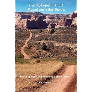
I have a trail guide, The Kokopelli Trail Mountain Bike Guide, by Alex Hearn. ISBN 1-59872-314-6 Used in conjunction with the Moab East map it’s a great tool. Gives suggesstions for cache spots and how to complete in however many days you choose. Great guide.
Here’s the link:
-
March 7, 2009 at 18:05 #77440
Don’t worry about the Dewey Bridge — the highway bridge is about a hundred yards further down the river from the (now gone) Dewey Bridge. But it is still a very good idea to check with the bike shops on the status of the trail before going.
Have fun! You guys are tougher than I am.
-
March 7, 2009 at 18:55 #77441
Man! This is some great info guys, thanks so much, keep it coming!
-
May 11, 2009 at 12:36 #77442
Thanks for all the great info guys, the ride was amazing!
I will definitely plan on doing this ride again, although I might try it in late season instead of early. We got rained on/mudded out on the first day and I broke my derailleur hanger 13 miles into a 40 mile day…boo!
Because of the rainy/muddy conditions we also had our schedule pushed back a full day…so it ended up being a 4 day ride, not 3 as planned.
All in all it was a great trip with some of the most amazing scenery and badass trails in the midwest.I highly recommend this epic ride to anybody looking for more than just a few hours worth of riding local trails.
I took some pictures on the trail, check ’em out in my profile! Or go to http://www.flickr.com and look for "Kokopelli Trail ’09"
BFD
-
October 24, 2012 at 21:32 #77443
Whats up,
Has anyone done this ride in the past year, would love to hear from you! I decided today a few friends and myself are going to start it on Monday! Not very many resources on the ol’ internet! Any info would be greatly appreciated!
I’m super pumped to get the LBS back on the bike, this time I’m using my Hardtail 29er!
check it:

-
October 24, 2012 at 21:52 #77444
I found the best map online and had it shipped to me before the trip, you might want that!
If you are not planning on driving the route first and making drop spots with water and food and such, you better plan on carrying alot with you. I don’t remember any potable water along the way.
If there has been any recent rain or any chance of rain RESCHEDULE!! Some areas of the trail are impassable when wet…(the trail turned to clay with a light rain and clogged up my gears, snapping off my rear derailleur)
Plan out your camping spots well, you don’t want to be scrambling for shelter in the dark!Good luck!!
btw…the descent into Moab is still one of my favorite memories on a bike!!!
Ben
-
October 25, 2012 at 07:01 #77445
Grab a copy of this book:
It’s out of stock at Amazon, but I think Over The Edge Sports in Fruita carries it.
Like BFD said, there is no potable water, you’ll need to leave drops, and if it rains: forget it. Bentonite clay is kryptonite to a mountain bike.
Also, the trail goes pretty high up into the Lasalles, so watch for snow at the higher elevations.
Good luck!
-
October 25, 2012 at 13:35 #77446"BFD" wrote
I found the best map online and had it shipped to me before the trip, you might want that!
If you are not planning on driving the route first and making drop spots with water and food and such, you better plan on carrying alot with you. I don’t remember any potable water along the way.
If there has been any recent rain or any chance of rain RESCHEDULE!! Some areas of the trail are impassable when wet…(the trail turned to clay with a light rain and clogged up my gears, snapping off my rear derailleur)
Plan out your camping spots well, you don’t want to be scrambling for shelter in the dark!Good luck!!
btw…the descent into Moab is still one of my favorite memories on a bike!!!
Ben
Hey Ben,
Hmmmm. I might just try and find one, I think its to late to order anything online! very spontaneous trip!!!! 😄
no plans on drops, You guys never used the Colorado River for water? I’ve heard mixed opinions of using it on the trail? I’ve drank some pretty nasty cow dump water on the Colorado trail. Plus I Dont believe the water is a murky in the fall as the spring.
Please tell me if I’m wrong and we can consider drops!
Weather looks great with no rain and not to hot 😃
Can’t you camp anywhere we are going to just see how we feel, if we want to sleep well take out our bivys and bags and sleep!
Yeah we expect to go thru some snow in the Lasalls!
Thanks for the INFO guys!
NEIL
-
October 26, 2012 at 08:52 #77447
Hi BFD,
I’m close to done with a guide book I’ll be publishing in time for next season. I live in Denver and see you’re in Highlands Ranch. I’d love to get you a draft copy in exchange for giving me feedback on the book. Hit me up in a pm and I can send you the stuff or meet up with you somewhere.
-
October 26, 2012 at 08:54 #77448
Ooops, I meant Niel. I just saw BFD’s post is kinda stale. When are you leaving Niel? Are you near Denver?
-
November 5, 2012 at 16:37 #77449
Thanks for the info Guys here is my Trip Report :[url]
http://gimmearaise.blogspot.com/[/url]
-
-
AuthorPosts


You must be logged in to reply to this topic.