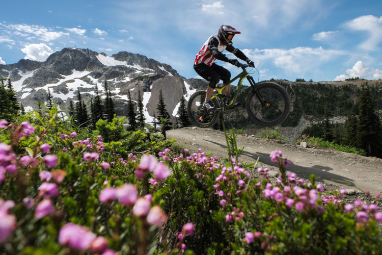
For day two of my aspen weekend in Vail, the goal was to get well out of town and hit some new-to-me and rarely-ridden singletrack. My map study had revealed an epic loop, rideable from town, which would include exactly that, along with a couple more popular local trails. But it was only accessible by starting on a long stretch of county road and jeep trails.
The new singletrack would be provided by the remote Lost Lake trail starting at over 10,000 feet on the edge of the Eagle’s Nest Wilderness. A heinously-steep road climb would deliver me there, and a couple of reputedly aspen-rich trails would deliver me back to town. My map, which was such a good friend in helping devise the route, would at one point be my foil as knobbies hit dirt in pursuit of this epic loop.
[see_also id=”197640″][/see_also]

The path to the high country began with a relentlessly-steep climb up the heavily-washboarded Red Sandstone Road, which had apparently not seen a grader in quite some time. Red Sandstone Road is part of a shorter, more popular route that finishes with the local favorite Son of Middle Creek trail as the downhill leg. The basic Son of Middle Creek loop can be executed in scarcely over five miles, but I was looking for more. My road climb alone would top the 10-mile mark even before hitting the singletrack, most of it as harsh grades. Bearing right onto Lost Lake Road a few miles up, the grade fortunately relaxed a bit, but the road became progressively more rocky and potholed. It is possible to drive to the Lost Lake trailhead with a sturdy high-clearance vehicle, but the road is so rough, in many places, it can actually be ridden as quickly on a bike as driven in a jeep.

The other problem reaching the trailhead is that, once high up, route finding becomes an issue, whether riding or driving. As I noted above, my usually trusty friend, my topo map of the area, became my foil. It was obvious it was out of date, and I came to believe it lacked sufficient detail, and was likely inaccurate from the get-go, even before the myriad of jeep roads in the area had been redesigned, rerouted, and confusingly altered. Some roads had five-foot-high berms bulldozed on them to prevent vehicular passage, while other new ones had been cut. There were three-, four-, and even five-way intersections, all badly or inaccurately depicted on the map, and I put in a few extra miles at 10,000 feet scouting, retreating, retracing, and retrying routes to find my way to the Lost Lake Trailhead. I began to wish I had just bailed at Son of Middle Creek, like everyone else around here!

As I started tried yet another road, hopeful something indicating Lost Lake would be around the next bend, a jeep came toward me and I flagged them down to inquire as to my course. After reluctantly rolling down the window and allowing the plume of smoke to escape (yes, this is Colorado in 2016), the folks inside assured me I was on the right track and the trailhead was indeed just around the next bend. Emboldened, I ventured on, but faced lingering doubts along the way as it was a good half-mile and a half dozen bends before the jeep road terminated at the Lost Lake trailhead.

But finally finding the Lost Lake trailhead was not the end of concern. Again, my map proved to be a problem. The map indicated that it was a very short distance from the trailhead to the lake, as in a matter of meters rather than miles. This would prove to be yet another inaccuracy. The trail was indeed marked as trail #1893, so I was confident I was on the right trail, but as the distance grew and the sun moved across the sky, I again entertained thoughts of turning around. Fortunately, the topographic contour lines on the map proved to be more accurate than trail and road placement, and by reading terrain, I was able to confirm my location right up to the lake… where the trail promptly disappeared! Actually, it just spread out into various paths along the lakeside, and I was ultimately able to locate the actual trail at the far end of the lake and, after a brief waterside respite, continue my journey.

The Lost Lake trail is continuously rocky throughout its eastern half and includes some mandatory dismounts, especially near the lake. It is impossible to find a riding rhythm here, going from one trials-like maneuver to the next. This is not to say this isn’t a great trail; it passes through remote wildlands, making no concessions to the cyclist while delivering stunning subalpine scenery to the hardy souls who venture here.
Leaving the lake requires a couple short but brutal climbs before beginning a long descent along a wooded ridgetop to the western trailhead. This ridge presented the first aspens of the day, amid high meadows with unobstructed views of Vail Mountain far to the southeast.
Upon reaching the western trailhead, I found it to be well-marked with a large kiosk and sitting on the wide, well-maintained, and well-traveled northwest end of Red Sandstone Road; much easier to find than the eastern side where I began my singletrack experience. Despite the obvious elimination of route finding difficulties, I concluded I had done things correctly since a west to east traverse of the Lost Lake trail would require a much longer climb on the singletrack rather than on roads. Moreover, I had reportedly awesome singletrack waiting for another extended downhill on my next leg, the aspen-covered Buffehr Creek trail.

What I hadn’t noticed was that the next couple miles on the Red And White Mountain Road was all uphill. Never at a harsh grade, but this late in the day, and at 10,000 feet in altitude, the fun factor was a bit diminished. Once again, the map failed to accurately represent the road and its connection to the singletrack, so more route finding was in order before finding the Buffehr Creek trail.
After hitting legitimate singletrack again, Buffehr bobbed and weaved its way down a high meadow on a tilt with excellent views of the surrounding canyons and mountains. One more stiff climb delivered me to the real goods: the rapid descent down a thousand vertical feet with magnificent aspen stands as my constant companions. Enough leaves had fallen to turn the trail into a magic, golden carpet. The switchbacks were just broad enough require minimal breaking and maintain flow. Even with an occasional sighting of I-70, Buffehr proved to be an absolute highlight of aspen season in Vail.

Shortly before hitting civilization the Buffehr Creek trail teed into the North Vail trail, a bench cut that traverses the steep hillside above I-70 from the far reaches of West Vail to the middle of town. The stretch of the North Vail trail from the T back to my start on Red Sandstone Road included a few brief climbs, some fast downhill, and some very tight switchbacks, all of which combined to make for a very satisfying finish to this 22-mile, 3,600ft of climbing epic loop.
A short sprint to a pedestrian bridge across I-70 and a quick zip through the village and I was back at my lodgings, unable to decide whether a nap, meal, or soak in the tub was top priority. That’s a pretty nice dilemma to have. Even with all the tribulations, day two of the Vail aspen weekend was a huge success.

As for my return to aspen country with new eyes, I’m fully able to appreciate them in a way that escaped me in my youth. Unlike the stunning multi-colored maples of the northeast, which awed me so when I moved to New England in peak season, the aspens are almost exclusively golden in color. There’s not a lot of variety like the reds and oranges provided by the eastern hardwoods. But that more monochromatic palette has its own unique and special appeal. It’s not just yellow, but a very special, wonderfully-vibrant shade of yellow that collects and reflects sunlight like no other leaf in any other woods. Combined with the white bark and set against the dark green backdrop of the pine, spruce, and firs, the aspens give brilliant and captivating contrast.
While it’s a cliche to say that the pictures don’t quite do them justice, it remains true and there’s nothing like being there, in their midst, as they briefly give their gift of spectacular golden, sun-drenched color each year. And even with all the miles I racked up over the two days, a couple reportedly-excellent routes remained unridden. As is so often the case, I have left myself a reason to return next year.