


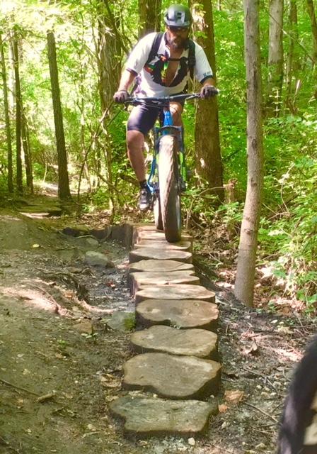
This is GBP's longest loop; follow the red shield "Permeter Loop" blazes. Starting near the main parking area, a trail of bench-cuts and bermed corners flows north and then east through the forest (there are four optional wooden skinnies) before reaching a climb and then following a wider trail NW along the lake (Perimeter Loop shares this short section with Lake Loop). The trail turns left (north) to a long, flowing section punctuated by switchbacks, a climb brings riders to the park's tallest hill (666 ft.). After a descent, a small log-over and some rollers, riders cross a bridge and then turn right passing the entrance bridge to Rock and Roll. The trail then heads south and riders encounter an optional conglomerate log-over. Past this the trail continues, crosses a clearing and then through a few narrow sections between giant logs. After that, the trail skirts, but bypasses Moore Rd. (a rutted dirt road) for about 3/8 mile--this section is interrupted by some rollers, a crossing over a large rock, an optional line across a bent skinny, and optional line over some cross-cut stumps, a ride over some cross-cut "lily pads" and a super-easy log crossing towards the end. Riders come to a clearing and cross the Advanced Access Trail and then enter single track following a narrower and more overgrown section of the former Moore Rd. At a Y in the road, (passing the Linton Road Connector to the right) the Perimeter trail bears to the left, passes through some log pinches and across a rocky gulley and eventually makes a sudden right. After a short climb, the trail winds through pine woods and then descends into a fast right-turn berm. A left and then a quick right takes riders on a trail with two S curves and eventually a fast dive downhill. Take in gorgeous views of Stryker Lake before reaching the SW parking lot (this short section again shared with Lake Loop). The trail continues across the parking lot and follows what locals call "The Fingers" a series of short ridges with dips in-between. The trail then straightens out and leads to some whoop-de-doos before closing the loop near the main parking area.


Loading reviews...View more